
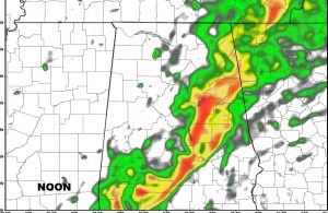
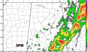
The Storm Prediction Center let the Tornado watch for North Central Alabama expire at 10. The severe weather parameters have slacked off just a bit, at least for now. However, I would not let your guard down much. We still have a strong line of storms moving through central Alabama, and conditions are favorable for additional watches and warnings later, especially as the storms slip southeastward. The greatest threat will be wind damage, but isolated tornadoes are not out of the question. The storms could will through the metro hour between now at Noon and then eastward into SE Alabama this afternoon.
Here’s a look at Future radar snapshots at Noon and 3PM
For now, officially, SPC still has us in a slight risk. That includes most of central and SE Alabama.

At this hour, a Tornado Watch continues for parts of SW Alabama until Noon.

If you have NOT downloaded our new weather app yet, get it today and allow notifications. It will be your best friends in severe weather situations! Latest radar and future radar, hourly forecast, 10 day forecast, access to all my videos, blog posts and tweets too. Plus LIVE streaming in severe weather. Search Rich Thomas Weather Network in the App store.