Severe thunderstorm watch covers east Central Alabama until 10PM. Roughly from about Wetumpka and Montgomery east to the Georgia border. Locally severe storm possible wind wind gusts to 60+ mph and the threat of hail.

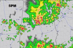
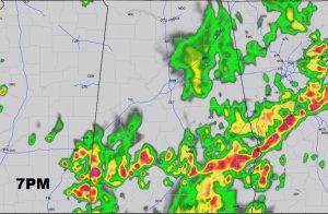
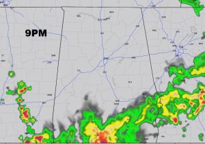
All afternoon we’ve been tracking a line of strong storms moving through north Alabama. This line will move southeastward affecting central Alabama by late afternoon & early evening, and then into south Alabama this evening and tonight. Gusty winds of 40+ mph have been reported with many of these storms. And, some of the storms will reach severe limits, with winds of 60+ mph. A few warnings are a likely. Again, this is a potential damaging wind threat, not a tornado threat. Some hail is also possible in the bigger thunderstorms. Our weather app will alert you if and when your area goes under a warning. If you do not have our weather app for your smart phone or tablet yet. yet, go to your app store and search Rich Thomas Weather.
Here’s some future radar snapshots through this evening