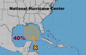
TROPICAL UPDATE (4;45PM 5/22/18) Spaghetti anyone? Model lines are now populating the map as Invest 90-L begins it’s trek toward the Gulf. Do you see a consensus yet? Stand by central Gulf coast. NHC probability of development 40%. Euro model higher at 50-60%. Should you be worried? My worry level is low. Much RAIN. Tropical Rain. Holiday Weekend downpours. Stay tuned. Much more in the morning on a very interesting Wednesday morning weather video.
—-
Previous update…
Good Morning! Our better than normal rain chances continue. On this video, I’ll update the chances for more drenching downpours over the next few days. A Tropical Disturbance, being tracked by the National Hurricane Center, could have a significant impact on our future weather, depending on the track it takes. The Memorial Day Weekend could potentially be a washout in spots. I’ll show the possibilities with the latest computer models, and the amazing rainfall totals which are possible. A lot of good information this morning on your Tuesday morning personal weather briefing.
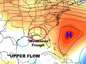
The atmosphere is primed again for numerous, widespread, showers and storms again today with locally heavy downpours. That “weakness” in the upper atmosphere will persist next couple of days.
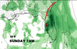
As far as where this tropical system could go….the GFS still like Florida and into Georgia. It shows the Low as rather weak.
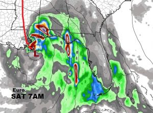
The Euro is a little stronger with the Low and faster, taking it to the mouth of the Mississippi river Saturday morning. (By the way the Canadian is in between the two, and takes the system to the central Florida panhandle over the weekend,
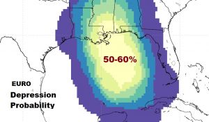
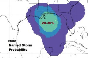
The EURO model offers probabilities for tropical development. It has a rather respectable 50-60% probability on Depression forming and about a 20-30% chance that this system will become Tropical Storm Alberto.
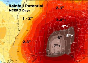
Depending on which model you trust, rainfall amounts could be rather excessive from now through Memorial Day Weekend.