
On this special update, it’s becoming clearer that we will see certainly a Depression the the Gulf over the Memorial Day Holiday Weekend, but more likely a Tropical Storm. Invest 90-L continues to develop over the Yucatan. Model trends continue to suggest that, late in the weekend, conditions will become more favorable for tropical cyclone development, an now, key models are coming together on a consensus on the potential track. The central Gulf coast is clearly in the cross hairs. The most likely time for landfall will be later in the weekend, particularly toward Sunday night or Monday. However the affects could begin even earlier. Air Force RECON will investigate the system Friday.
By the way, the first name on this year’s list of tropical names is Alberto, a name which has been re-cycled many times before.
Before I show you the models, here’s the latest from the National Hurricane Center, which now says there is 90% chance that Invest 90-L will develop into a depression or Tropical Storm.
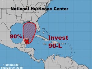
Special Tropical Weather Outlook

. A broad surface low drifting slowly northward over the eastern
Yucatan Peninsula continues to become better defined. Although
showers and thunderstorms, along with strong gusty winds, remain
primarily over the adjacent waters of the northwestern Caribbean
Sea, environmental conditions are forecast to become more conducive
for development through early next week, and a subtropical or
tropical depression is likely to form by late Saturday over the
southeastern Gulf of Mexico. An Air Force Reserve reconnaissance
aircraft is scheduled to investigate the disturbance Friday
afternoon, if necessary. Locally heavy rainfall is forecast across
western Cuba and over much of Florida and the northern Gulf Coast
into early next week. In addition, the threat of rip currents will
steadily increase along the Gulf coast from Florida westward to
Louisiana over the Memorial Day weekend. For more information on
these threats, please see products issued by your local weather
office. The next Special Tropical Weather Outlook on this system
will be issued by 800 PM EDT this evening.
* Formation chance through 48 hours...high...70 percent.
* Formation chance through 5 days...high...90 percent.
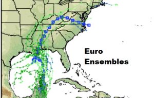
MODEL TRENDS: Both the GFS and the EURO tracks have come very close together on the potential path of this tropical system
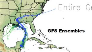
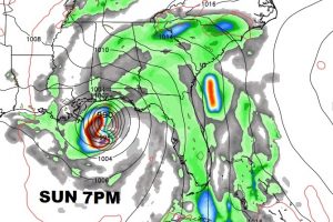
The GFS has the system just south of the Mobile Bay on Sunday night at 7PM. Then it lifts northwestward into central Mississippi.
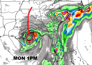
The EURO is a little slower on arrival time. It takes the center just south of the Mobile bay at 1PM on Memorial Day Monday. Then the system lifts northward, hugging the Miss/Alabama border Monday night through Tuesday and into Tennessee on Wednesday.
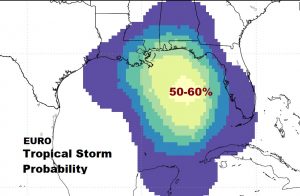
The Euro now gives close to a 60% chance of this system becoming a tropical storm.
BOTTOM LINE FOR US: These two model tracks from the GFS and EURO, put us on the more active east side of the system. The potential exists for some very heavy rainfall, and when the system comes ashore, tornadoes are possible on the right side of the system. A tornado watch is almost a given, again, depending on when the system makes landfall. It could spoil a lot of holiday plans.
—
I’ll have much more for you in the morning on a Special Friday morning video update, online by 4:45AM.
Rich