
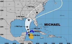
Air Force RECON finds Tropical Storm is a little stronger, winds of 50 mph, located 130 ESE of Cozumel,MX., moving NNE at 3, pressure 999 millibars. Michael could become a hurricane by Monday night or Tuesday. The Threat to the US Gulf Coast is increasing. Michael will approach the northeast Gulf coast as a Category two hurricane on Wednesday.
Here’s the wide shot on the Michael cone.
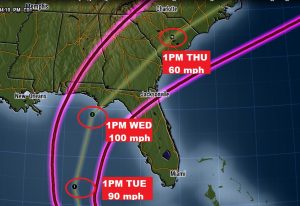
A close up on the Michael cone. Notice the cone is shrinking as we go forward in time, now from I-65 eastward. The hurricane with 90 mph winds Tuesday afternoon will peak at category 2, 100 mph, just before landfall on the northern Gulf coast, and then rapidly accelerate northeast into the Carolinas.
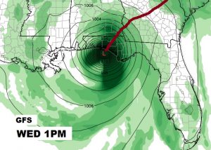
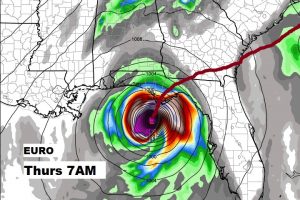
MODEL DIFFERENCES: There continues to be differences in two key global model solutions. The GFS continues to be the faster of major models, and farther west. The Euro has been very consistent. It’s father east with its solution, and its several hours slower. The Euro track takes a hard right turn after landfall. Here’s a snapshot of the GFS at 1PM Wednesday and the Euro and 7AM Thursday. These are only two of many models.
—
Join me in the morning for a very important video update, with the latest information on Michael. Hopefully, after today’s RECON data is input into tonight’s 00Z model runs, we will have a much clearer idea of the final solution on Michael’s track and an update on timing. My alarm goes off at 1:30. Your video will be online by 4:45AM. Have a good evening.
Rich