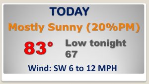
Good Morning! We have a very warm Halloween forecast, as we aim for the low to mid 80’s. But get ready for a significant change. All eyes on a potent storm system and cold front moving into the western Gulf region. It will bring a severe weather threat to Alabama tomorrow as we start the month of November. On this video, I have the latest on timing and the potential impacts we can expect. That front will also usher in sharply cooler temperatures. I have the latest on the weekend forecast and a look ahead into next week, too.
Ominous set-up today, with a significant severe weather/tornado risk across the western Gulf states, Today, we are headed for the 80’s on a very warm Halloween.
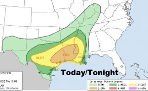
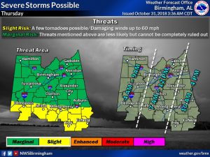
Tomorrow, virtually all of Alabama is in a Severe Risk. For north Alabama it’s a Marginal Risk, with mainly a damaging wind threat. Across south Alabama in the yellow, stage 2, slight risk area, a few spin up tornadoes are possible, too.
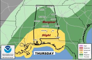
NWS has a faster time line on the arrival time of the main squall line (QLCS). They bring in the line across central Alabama by late morning into the early afternoon, and into southeast Alabama by mid to late afternoon, before exiting the state.
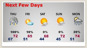
After the showers and storms Thursday, Friday will be breezy and much cooler. The sharply cooler air will persist through the weekend. with low to mid 40’s by dawn on Saturday and Sunday morning.
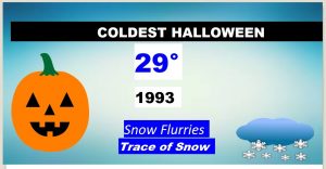
A little Halloween weather history for you. The most interesting day was 25 years ago today when it snowed! Montgomery recorded a Trace of snow at the aiport. That’s the earliest snow in history. Records began in 1872.