
Welcome to December. As is often the case, during this time of the year, we are tracking an approaching storm system, which poses at least a limited severe weather risk today. This, obviously could have an affect on some area Christmas parades and other holiday events scheduled. At the moment, it appears to be a “low end severe risk”. I’ll explain.
SEVERE WEATHER RISK TODAY: There are a whole series of factors, on the Severe Weather Checklist, which have to come together at the right time, in the right way. Today, some of those factors are present today, but many factors are not. Certainly, daytime heating, with highs in the 70’s and dewpoints zooming into the “juicy” 60’s, as a storm system approaches…might be enough for strong storms to get going. And, there is enough “directional shear” or spin, for an isolated tornado threat. ‘Tis the season for that.
Today’s outlook from the Storm Prediction Center, shows a somewhat bullish approach, with a level 2 ‘slight risk’ covering much of the state from Birmingham southward today. There’s no doubt in my mind that the most prominent threat will be in southwest and over south Alabama today.
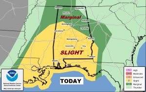
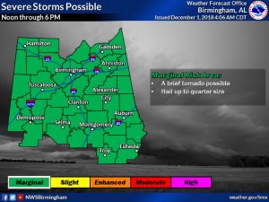
NWS in Birmingham has taken a more conservative approach today’s threat level, and I agree with their approach and reasoning. They have much of central Alabama in a marginal risk. A few strong storms, with gusty winds, quarter size hail are possible. An isolated tornado or 2 can’t be ruled out. The greatest threat for potential severe storms will be from Noon to 6PM.
TODAY: Widespread morning rain and a few storms, will give way to scattered showers and storms by afternoon and evening. A few storms could become strong. Keep our weather app handy when you are out and about. It will instantly alert you to a watch or warning for your location. Breezy today with brisk east winds of 10 to 20 mph. High today will be in the low to mid 70’s. (Yesterday’s high was 77). The shower risk continues tonight. Very mild tonight, with an overnight low of 64.
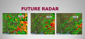
Here’s some Future Radar snapshots. Don’t take these literally, but, these will help you get a sense on the density of showers & storms at various times today.
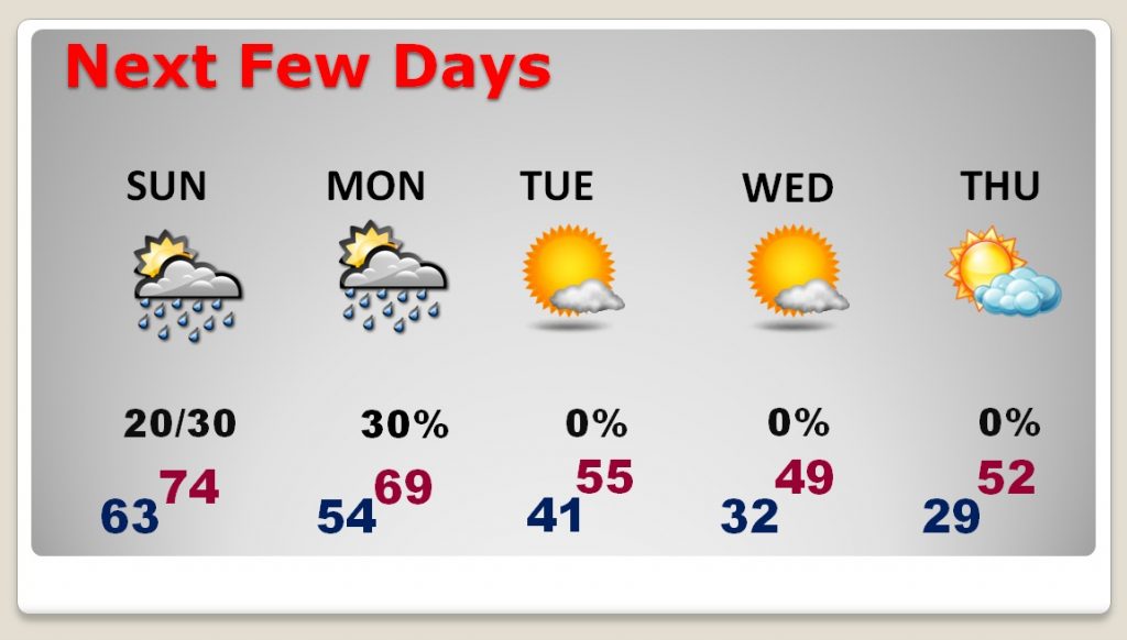
NEXT FEW DAYS: Sunday will be a rather remarkable December day. The rain chance will be relatively small, in the 20% range. There will be a good but of sun around, with a high in the mid 70’s A cold front moves through the state Monday – Risk of showers…upper 60’s Sharply colder air moves in Monday night through mid to late week. We’re back to the freeze mark by Wednesday morning, with highs only in the 40’s. We could be in the upper 20’s on Thursday morning.
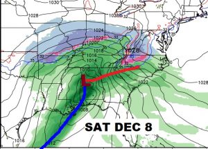
LATE WEEK TEASER: A very dynamic storm system will begin to affect the state, and much of the Southeast, by Friday night into Saturday (Dec 7-8). In the warm air sector, strong thunderstorms can’t be ruled out. In the cold air sector, north of Alabama, snow and ice will be an issue. On the back side of this system, parts of north Alabama could see a few flurries by Sunday, perhaps, as much colder air funnels in. We’ll monitor this system in the week ahead.
– –
Have a great Saturday! There will be another blog update for you early Sunday morning, with an update on the Cold week ahead. I will have your next complete video update Monday morning online by 4:45AM.
Rich