
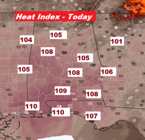
We were dangerously close to Heat Advisory Criteria yesterday. But, today will be a tad hotter, so a HEAT ADVISORY now covers most counties in central and south Alabama, and all the Beaches in Alabama and NW Florida. Dangerous heat indices will top out in the 105 to 110 range. Please take precautions. Limit sun exposure as much as possible. Stay hydrated. After today, mid 90’s are still in the forecast Sunday through at least mid week, with triple digit heat indices. There will be a handful of cooling showers & storms around each day, but not in great supply.
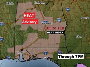
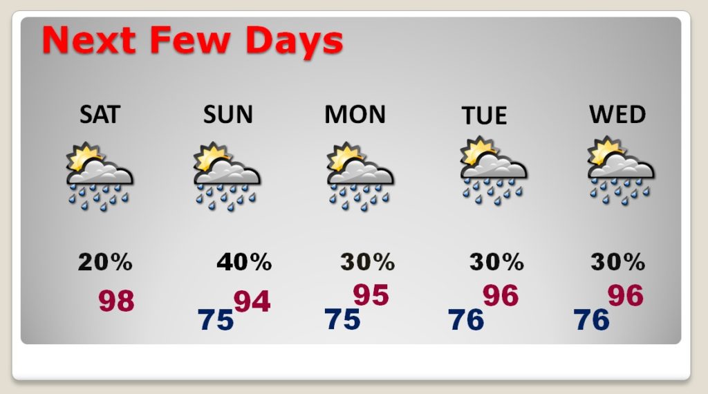
TODAY: Today’s actual high will be 98. (Yesterday’s high in Montgomery was 98 with a Heat Index of 107. We’ve been to 98 three time this year but not quite to 99 yet) Widely scattered storms will populate the radar by this afternoon and this evening. Unfortunately, only a handful of lucky communities will benefit. The Heat Advisory will remain in effect through 7PM tonight. Tonight’s low…a steamy 76.
NEXT FEW DAYS: An approaching disturbance could help improve storm coverage a little bit by Sunday afternoon/evening. Otherwise, look for a summertime standard 30% most afternoons through mid week, with more intense heat.
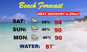
BEACH FORECAST: Heat Advisory. Dangerous heat indices as high as 109. BUT, the rain chances are getting better and better. That’s great news. At least a 50/50 chance today. Watch out for dangerous lightning. The beach is a particularly dangerous place in a storm. Rip current risk is listed as low to moderate from Gulf Shores through Pensacola. However, officials in Walton and Bay county Florida continue to warn that “strong and frequent rip currents are expected today and Sunday”. This will affect many popular beaches from Ft. Walton/Destin, eastward through 30-A beaches and Panama City. Please pay attention to the flags on the Beach. A red flag means stay out of the water.
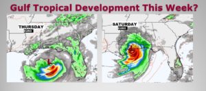
TROPICAL TROUBLE IN THE GULF THIS WEEK?: The models have been hinting for days of some potential home-grown/backyard northern Gulf tropical development in the week ahead. The Euro is bullish on this idea. The GFS not so much. We’ll be monitoring. The Gulf waters are very warm.
– –
I will have another forecast update tomorrow morning. Have a nice holiday weekend.
-Rich