
Timing is everything. We are going to enjoy a weekend in-between storm systems, before some early week drama arrives. The storm that brought the drenching rain has exited. Only the clouds remain. Temperatures will begin a warm-up, especially Sunday and Monday. And, that will set the stage for a potential Severe Weather Threat late Monday and Monday night. Then, get ready for another BIG Temperature Plunge. Lots of active and changeable weather is in our future over the next few days, so we are going to enjoy this quiet weekend.
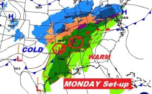
Here’s the Monday morning map set-up.
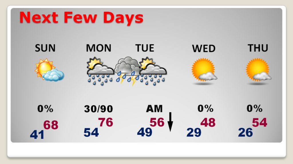
TODAY: Rain-free and pretty nice! A sun/cloud mix. The normal high for this time of year is 60. Today we will be close to normal. Tonight’s low will fall to about 41. (Normal is 38). West wind at 6 to 12 mph today.
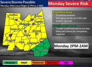
MONDAY SEVERE WEATHER RISK: Monday will be very warm, with a high in the mid 70’s. With ample Gulf moisture heading northward, ahead of a strong cold front, the stage is set for severe weather in Alabama. It’s a classic set-up, with low pressure moving northeast from Louisiana to Tennessee. Looks like by far the greatest threat is along and north of I-85, and the Level 2 (slight risk) threat area covers about the north and west 2/3 of the state. The Risk window is from about 2PM West to 2AM in the far southeast. All modes of severe weather are possible including damaging winds to 60+ mph, large hail and some tornadoes. We will continue to monitor developments through the weekend.
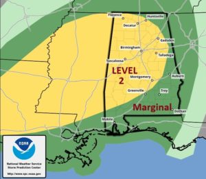
Here’s the updated Severe Threat Map from NWS Birmingham, covering their area of responsibility. It is very similar to the coverage area from the Storm Prediction Center. Notice, even southeast Alabama is in a Level 1 Marginal Severe Weather Risk.
Here’s the Map from the Storm Prediction Center, showing a wider view of the region. The Marginal Risk extends through SE Alabama inot Georgia and north Florida.
NEXT FEW DAYS – BIG CHANGES: Upper 60’s Sunday and mid 70’s Monday. Thunderstorms Monday afternoon & Monday night. Rain tapers off Tuesday morning. Falling temperatures Tuesday, leading to a Big Temperature Plunge by Tuesday night. Coldest mornings Wednesday and Thursday morning with upper 20’s.
—
Have a great Saturday! Enjoy the various Christmas Events, including Christmas on the Coosa!
-Rich