
Good Morning! Instead of a video this morning, I have this blog update for you. I’ll have some updated news about Bailey later in this blog post.
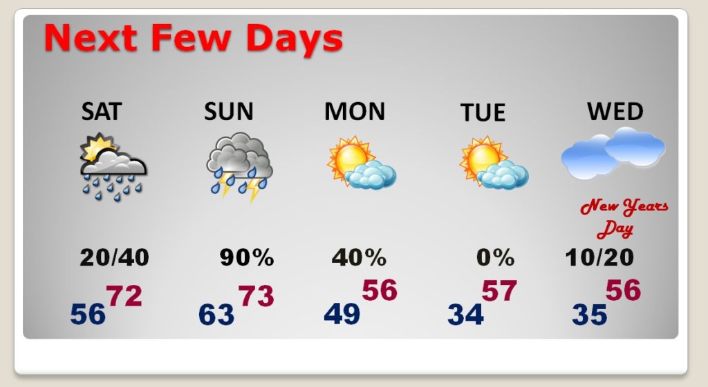
First, let’s talk weather. We have had a remarkable Christmas week of comfortable, unseasonably warm temperatures. Today, Saturday & Sunday we will be near or above 70 again, before a big temperature drop on Monday. Rain chances will be tiny today and Saturday, a little better Saturday night, but the main event will be Sunday Evening & Sunday Night, as a strong cold front approaches, bringing a round of showers and storms, and at least the possibility of a few strong/severe storms.
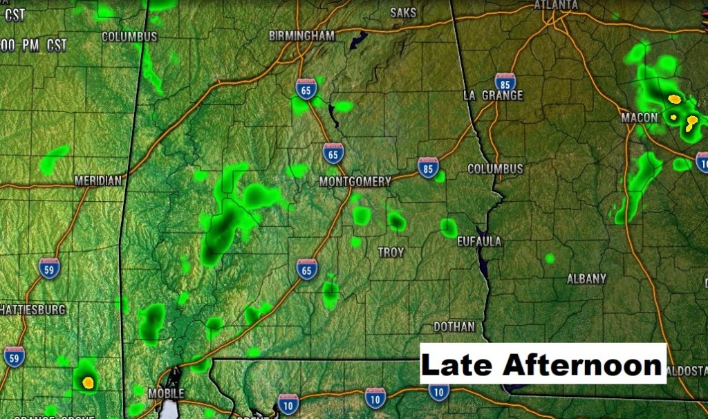
TODAY: It should will be another very mild December. Mostly cloudy. There will be a couple of showers on the radar mainly from I-65 westward. I’ll keep the rain chance under 20%. High today near 70, perhaps a tad above. Low tonight 56.
Here’s a Future Radar snapshot, showing a few isolated showers, perhaps, popping up this afternoon. Your chances of seeing one are very tiny.
NEXT FEW DAYS: Saturday will be much like today. Mostly cloudy. Isolated showers possible. Better chance of showers late Saturday night. Showers and thunderstorms become likely Sunday and Sunday night. Sharply colder Monday. I have now removed rain from the forecast for New Years Eve and New Years Day. The better rain chances will probably hold off until Thursday and Friday, January 2-3.
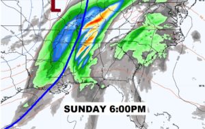
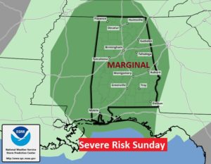
SUNDAY STORM SYSTEM – SEVERE?: The timing on the Sunday system is slower now. Showers and thunderstorms will begin in the west Sunday afternoon, and spread eastward Sunday evening and Sunday night. There will be enough instability for some stronger storms, possibly reaching severe limits. A Marginal Severe Risk now covers the area. The main time window appears to be from 3PM to 9PM. (That will be refined as we get closed to the event.) Damaging wind gusts to 60+ mph will be the main risk. A couple of tornadoes are not out of the question. It appears that a slightly higher risk will be west of I-65.
Here’s the map set-up at 6PM Sunday evening.
The latest outlook from the Storm Prediction Center, has most of the area in a Marginal Severe Risk on Sunday.
BAILEY NEWS TAKES A TURN FOR THE WORSE:
First, Thank YOU! I am simply overwhelmed and gratified of the outpouring of well wishes, support and prayers for my dog Bailey. I waited close to 8 days for a pathology report on her biopsies.
She has spent yesterday and last night in ICU at Carriage Hills Animal Hospital. I got some pretty awful news yesterday about a very aggressive form of cancer. The cancer is in the lymph nodes and in the liver. They didn’t sugarcoat the prognosis. It’s not good. Nevertheless, we’re doing what we can, and prayers are powerful. I have some important decisions to make about her future, and the correct course of action.
Again, thank you for keeping her and us in your thoughts and prayers. It’s difficult, and many of you who have gone through this understand how tough certain decisions can be. I last went through this with my dog Skyy in 2012. Bailey and I have been together for 7 years now. She’s a rescue from MHS. She might have been two when I met her 7 years ago. Her age is unknown. She had a tough early life, but her life, and my life, got a whole lot better when we met at the shelter.
Here’s Daddy saying goodnight to her last night in ICU. That smile was the result of a steroid shot that perked her up a bit. Smiles have been rare lately. Her formerly blue eye is now yellow. A result of the cancer affecting her liver.

I’ll have additional blog updates over the weekend.
–Rich