
A tornado now covers extreme west and northwest Alabama until 9PM. Threat of severe storms with damaging wind gists to 60+ mph. A few brief tornadoes are possible.
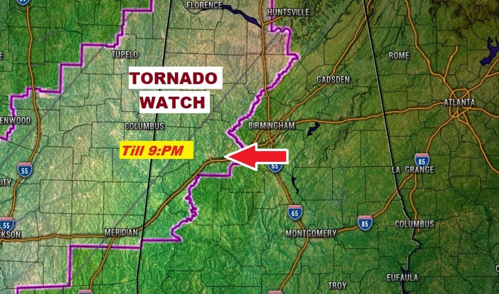
EAST of the WATCH area, a Marginal Severe Risk covers the area as far east as a Talladega, Montgomery Greenville line through Midnight, as a line of thunderstorms moves eastward. By about Midnight, with the line perhaps near or just past I-65, the severe potential should rapidly diminish. East Alabama should be off the hook.
- – –
EARLY MORNING UPDATE:
Good morning! Our very warm December airmass is still in place. Highs in the mid70s today, with dewpoints in the “juicy” 60’s will lead to storm development this afternoon, especially in the west half of the state this afternoon. Then, tonight, a line of storms will march across the state along a Cold Front, which will bring a screeching halt to our string of days in the 70’s. The cooler air that follows, for New Years Week, will actually be closer to normal for this time of year.
TODAY & TONIGHT: Showers are possible anytime today. But, the better chance of showers and a few thunderstorms will begin this afternoon, and will continue through the evening and tonight. More on the Severe Weather Threat below. Breezy today. South winds 10-16 will gust to 20. High today 74. Colder by late tonight. Low 51.
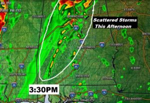
MARGINAL SEVERE THREAT: This will be a “low end” severe weather threat in Alabama today and tonight, The Severe Threat could begin as early as about 2PM in the western strip of counties. Individual thunderstorms will develop west of I-65, some of which could become severe, with damaging wind gusts 60+ mph. Brief tornadoes are possible. That’s phase one of today’s threat.
Phase two, involves a line of thunderstorms, along the cold front tonight which will march eastward reaching roughly the I-65 corridor at Midnight. Again, damaging wind threat to 60_+ mph appears to be the main risk, but even with the line, an embedded brief tornado or two can’t be ruled out.
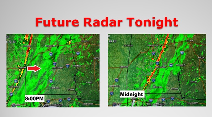
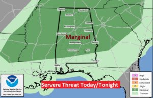
By about Midnight, with the line perhaps near or just past I-65, the severe potential should rapidly diminish. Therefore, on this graphic from NWS Birmingham, notice how they indicate that the eastern counties have been removed from tonight’s Marginal Severe Risk. I am totally onboard with this assessment, that the line will begin to lose its severe potential by about Midnight, and east Alabama should be off the hook.
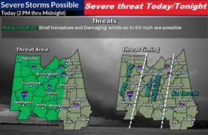
Even beyond the counties covered by the Birmingham Weather office, the wider threat of a few severe storms extends into south Alabama as well, as far south as a Troy/Monroeville line. This is the threat area outlined from the Storm Prediction Center.
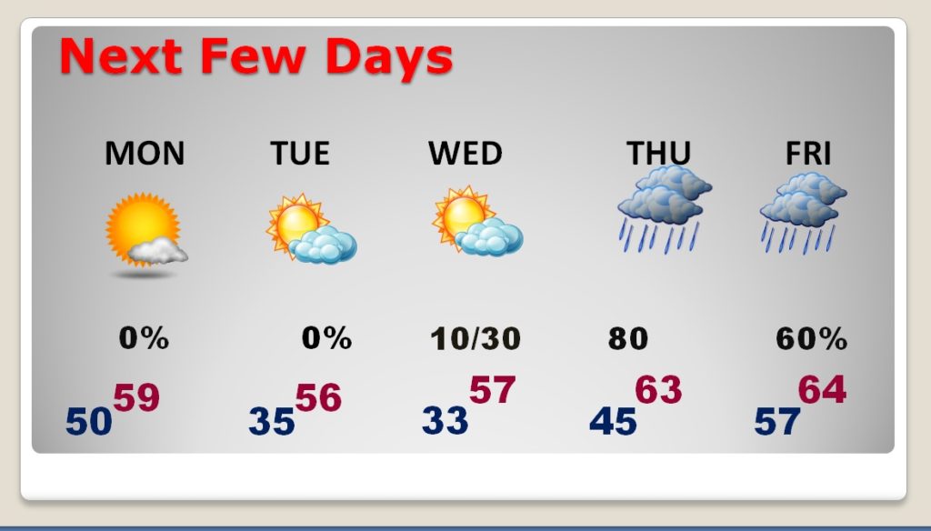
NEXT FEW DAYS: Behind the front, Monday will be about 15 degrees cooler. We will be in the 30’s on Monday night and Tuesday night, as the year 2019 comes to a close. Another storm system will bring a showers threat perhaps late New Year’s Night, but more likely Thursday and Friday. Too early to talk about any potential severe weather threat.
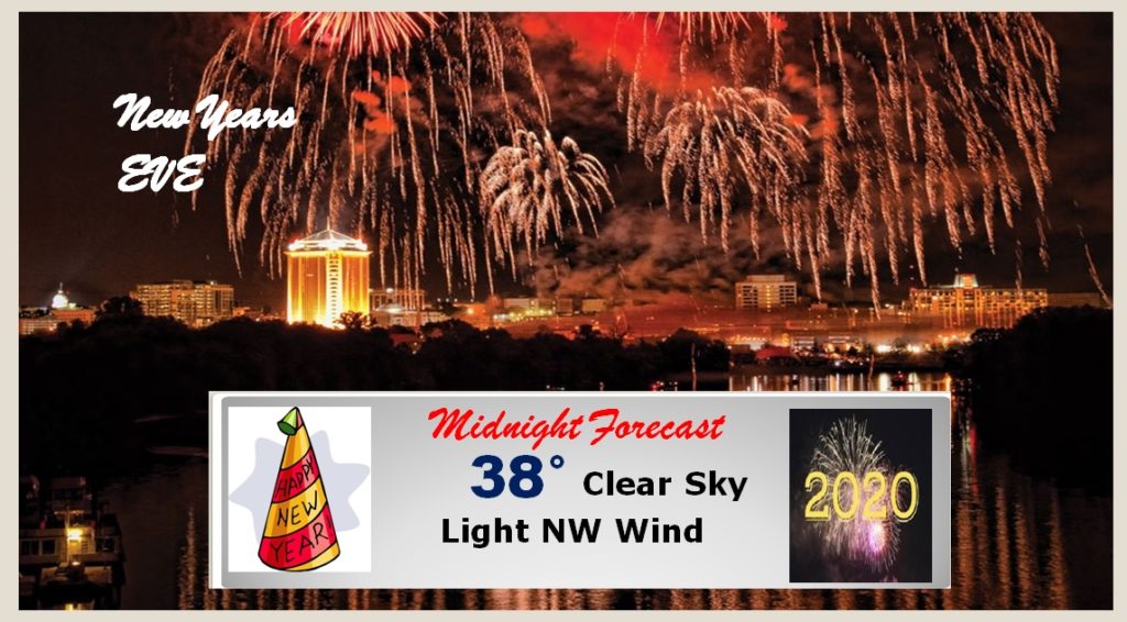
NEW YEAR’S EVE FORECAST: New Years Eve in Montgomery, and around the area, will be uneventful, and typical for any New Years Eve night, based on averages. Skies will be mostly clear, and the Midnight temperature will be near 38. Wind chill should not be a factor. Most of New Year’s Day should be dry with highs in the upper 50’s Near normal.
BAILEY’S GOOD SATURDAY: Thanks for your continued support, and interest on my dog Bailey’s health!
That 24 hours in ICU Thursday really did wonders. It perked her up quite a bit. Yesterday, especially, she was eating, walking, and feeling pretty good. Visits from good friends brought a lot of smiles. She was her regular self. We’ll take each day one at a time. Each day is a gift. We have an appointment with her cancer doctor tomorrow morning. It will be great to meet Dr. Smith, and to get her assessment on Bailey’s prognosis.
Look at this great Bailey smile, during a visit from our great friend Greg Budell.

—
Stay weather aware today, especially by this evening and tonight. Our weather app will keep you up to day, and will instantly alert you to any watch or warning for your location. You can download it in the App store, by searching Rich Thomas Weather. I will have a video update for you first thing tomorrow morning. It should be online by about 4:45AM, or thereabouts. Have a nice Sunday!
–Rich