
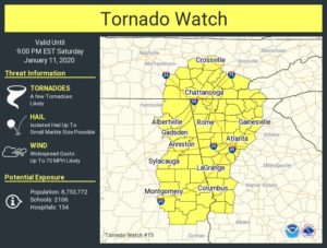
12:45 pm UPDATE:
A tornado watch has been issued for parts of Alabama, Georgia, North Carolina and Tennessee until 9 PM EST.
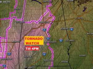
8:00AM UPDATE:
TORNADO WATCH till 4PM , covers all of West Alabama, as far east as Chilton, Autauga, Lowndes, Butler Crenshaw, & Covington. More watches further east later….
5:00AM BLOG UPDATE:
Severe weather is likely in Alabama today. A significant severe event is certainly possible, with widespread straight-line thunderstorm wind damage and embedded tornadoes. Some tornadoes could be strong. (EF-2 or higher) There will be several Watches and Warnings in the state today. A tornado watch will begin early in the western counties and spread east during the day. Severe weather will exit the eastern and southeast counties by about 7 or 8PM.
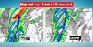
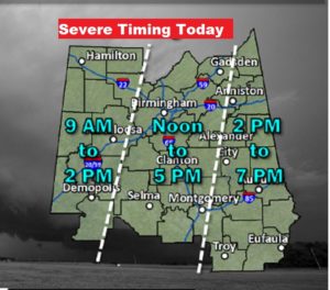
Here’s the Map set up: Strong front on the Mississippi/Alabama line at Noon, moves east to the Georgia line by 6:00PM. After the front passes by you, your severe threat ends.
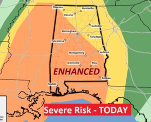
SEVERE RISK LEVEL: NWS has opted to stay with an ENHANCED risk for today. Level 3 out of 5. This is significant and rare in January.
TIME LINE: This hasn’t changed much. Action could begin in the western counties at 9AM. Much of the central counties will be in the Noon to 5PM timeline, and exiting extreme east Alabama by about 7.
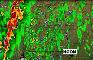
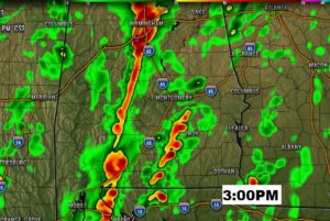
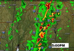
FUTURE RADAR: The main threat involves the strong line of thunderstorms, with potentially widespread straight-line wind damage and embedded tornadoes in the line. Another potential risk/worry involves individual super cell thunderstorms ahead of the line, which could begin to rotate and drop tornadoes.
Don’t take these literally..but here’s a few snapshots at key hours. Noon, 3PM and 5PM. You can see the line and you can see individual cells ahead of the line.
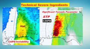
SEVERE WEATHER INGREDIENTS: With highs in the mid 70’s, and plenty of Gulf moisture, the severe weather parameters are ample. Look at the potential instability map called CAPE. There will be plenty of shear or spin, and lots of CAPE. These are key ingredients for tornadoes and severe storms. Notice the Significant Tornado Parameter map. Values over 2 are get my attention. On this map you see numbers from 3 to 6 over central and south Alabama. This bothers me.
GO TO YOUR SAFE PLACE TODAY:
From NWS, I like what they are saying here:
“Severe thunderstorm warnings should also be treated
Seriously, given the strong wind potential and potential for
tornadoes to spin up with little lead time, and especially mobile
home residents and those with many trees near their home should
consider moving to a safe place even for severe thunderstorm
warnings
Today, it’s a good idea to go to your safe place even for severe thunderstorm warnings.
WEAR SHOES, and if you have helmets, use them in your safe place.
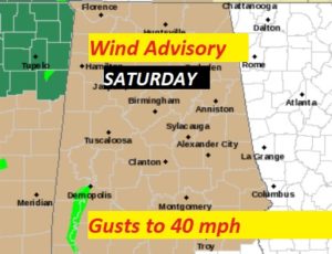
WIND ADVISORY: This is a powerful storm system, with deepening low pressure. Even outside of thunderstorm areas, winds could gust to 35 to 40 mph. You might want to pick up loose objects around the yard that could be projectiles.
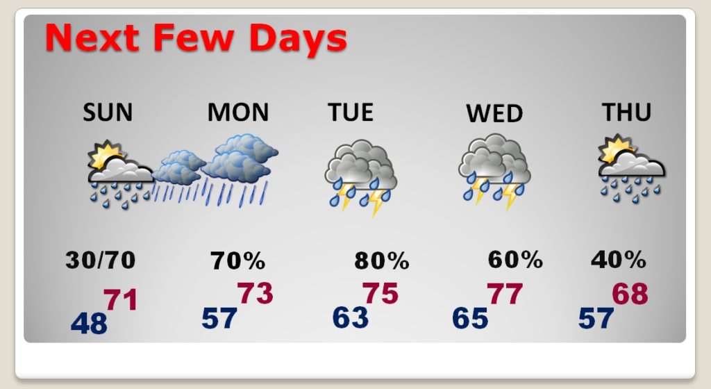
NEXT FEW DAYS: The front that moves through today, will back up late Sunday and bring rain back into the state Sunday night. Then, it will be wet at times just about all week and very warm temperatures for January.
—
Stay safe and aware. I will be in the Bluewater Weather Center all day for this event. We will be live-streaming coverage on your app on the You Tube Tab…also you can see that on You Tube, of course and on our website.
ALSO, I’ll be updating social media as much as possible. (Facebook/Twitter) I’ve got some help in the office today. My weather producer and my friend Rosie Brock will be helping, especially with social media. She’ll be posting and monitoring reports. You can also help us by giving us your reports on our Facebook post, in the comments section.
My Twitter: @RichThomasWX
AND, needless to say, we will be interrupting as needed, across the eight station Bluewater Radio group, including 100,000 watt WBAM 98.9.
ALSO, we have a direct hook-up with the Alabama News Network. (CBS 8 and ABC32) Shane Butler and his crew will cut-way to me at times. We will be chatting back and forth during their live coverage.
TAKE US to your safe place. You watch our LIVESTREAM on our APP, while you are in your safe place.
-Rich