
Good Morning! This will be a tough blog to write, especially when it comes to the big question mark – will any of that arctic air reach Alabama in the next 6 or 7 days, or will the arctic air fall short of reaching us?
Let’s start with the easier part of the forecast – today through Thursday. Briefly…wet at times today & tonight, Sunday dry and tolerable, warmer Monday. Showers and perhaps a couple of thunderstorms by Monday night and Tuesday. Stronger storm system Thursday.
I’ll address the arctic question farther down on this Blog update. Spoiler alert, all types of frozen precipitation have been removed, for now. Fortunately, it looks like the moisture may exit before the coldest air arrives, IF it arrives. Bear with me.
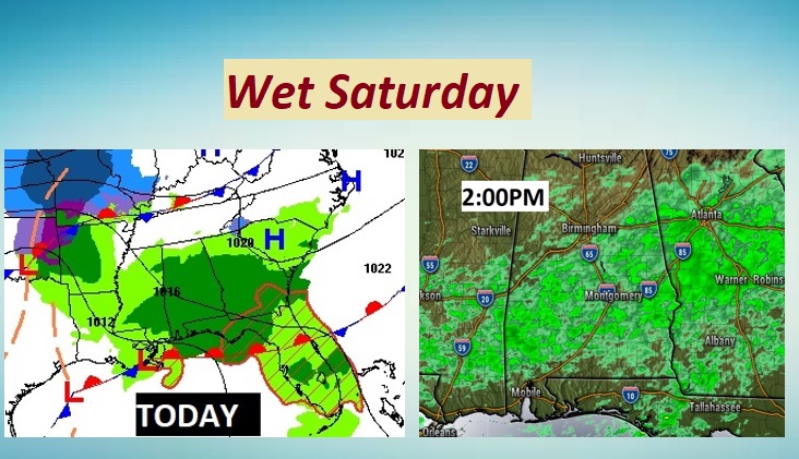
TODAY: Bands of showers dominate areas south of US 80 this morning, along and south of a cool front. By afternoon & tonight rain will become more widespread across the area. Chilly today..high 48. Low tonight 40.
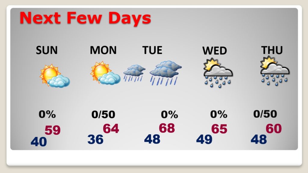
SUNDAY: A better day. Dry. Clouds will dominate much of the day. We may get some “sun breaks” before sunset. Because of the clouds, I have lowered my high temperature expectations to about 57.
NEXT FEW DAYS: Monday is a better day. Sun/clouds High 64. Monday is the Best day of the week. Showers and thunderstorms Monday night & Tuesday, with disturbance #1. Risk of showers and some thunderstorms Wednesday night into Thursday with storm system #2. A few stronger storms can’t be ruled out Thursday. Upper 60’s Tuesday through Thursday.
TRACKING THE ARCTIC AIR – MODEL MADNESS LATE WEEK:
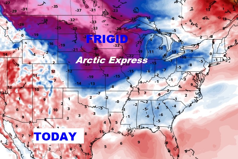
Wow. The models have flip-flopped in a big way as we get towards day 6-10. There is absolutely NO agreement on the details. The problem? Bitter cold artic air has entered the nation. A strong high pressure ridge over the Bahamas is keeping the Arctic Air at bay. So, does the Arctic Air eventually win out? OR, does the Warm Bermuda High hold steady? Here’s where the Arctic Air is located today, with a snowstorm riding along the southern boundary.
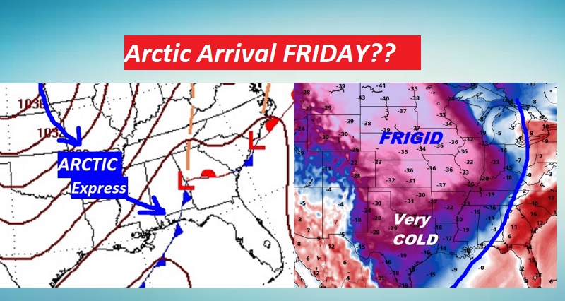
The American GFS model says the Arctic Air will win. It indicates the temperature crash begins during the day Friday. It indicates a VERY cold Valentine’s Weekend. However, the EURO Model (ECMWF) says we stay in the 60’s through Monday the 15th. Do you see the forecast dilemma?
As mentioned earlier in this Blog, the threat for frozen winter mischief is off the board for now. Stay tuned. We are still several days out.
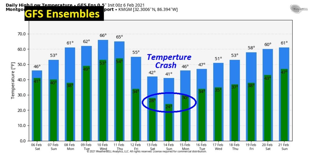
Let me show you the GFS Raw Ensembles temperature guidance, a blend of dozens of GFS solutions. It shows a cold Valentines day weekend, but the Control run of the GFS is even more extreme, with highs only in the 30’s
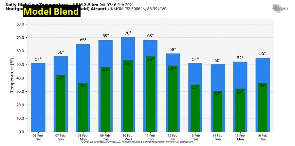
This is a 10 Day BLEND, taking all the models into account.
I’ll have another Blog update early tomorrow morning. We’ll know more…I hope. ???? Have a nice weekend.
–Rich