
Good Morning! Saturday was nice. Today will be nicer. What a great weekend so far. The morning chill will fade quickly. Total sunshine will help boost our temperatures. By afternoon, we should be in the upper 60’s.
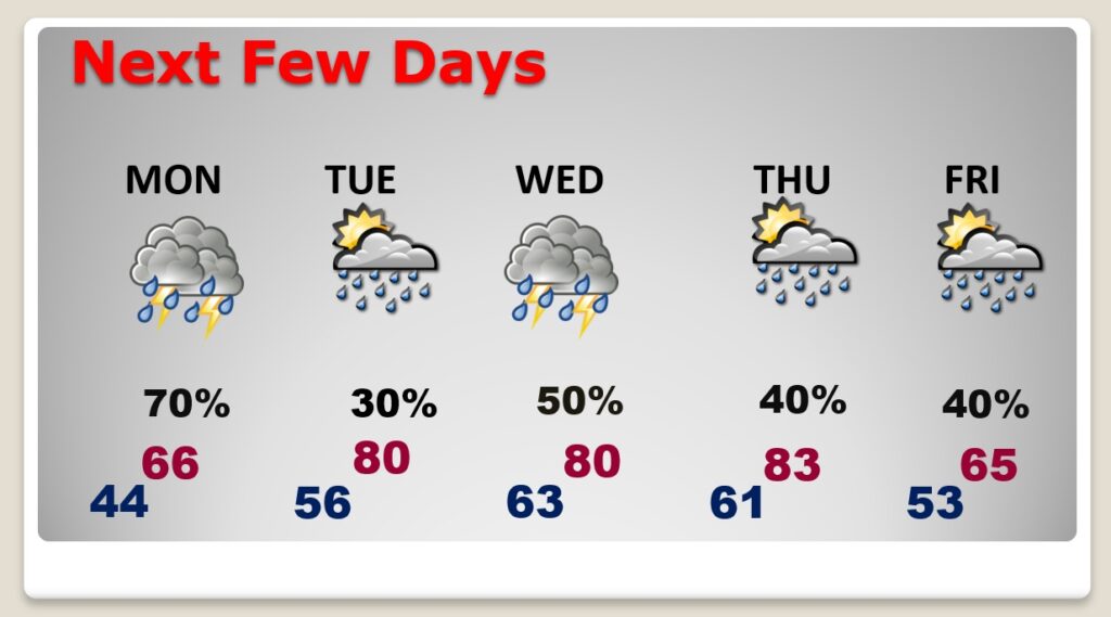
Rain returns Monday. Showers and a few thunderstorms become likely, especially by Monday afternoon. Expect a big warm-up Tuesday through Thursday. We will be 80 or above for about three days. A parade of storm systems will brush by the state in the week ahead. The RISK of showers will be in the forecast every day. But, as you’ll see on this blog update, the better rain chances will be in the northern half of the state. I’ll explain why below.
Today we are on the backside of high pressure, anchored over the middle Atlantic States. Should be a nice day throughout the Southeast states.
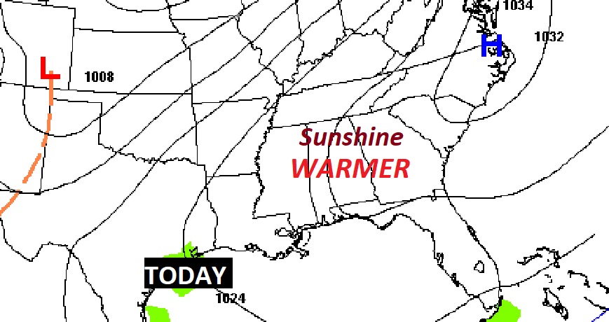
TODAY: Today will be a really, really nice day. The morning chill will fade quickly. Sunshine will dominate. Yesterday we had a high of 63. Today’s high will reach the upper 60’s. (Normal high 66) The breeze will not be as strong as yesterday. East at 5 to 11 mph. Increasing clouds tonight, not as cool. Low 44.
NEXT FEW DAYS: Showers and a few thunderstorms become likely, especially by afternoon. Warmer Tuesday through Thursday. Daily risk of showers. Very warm with high near or above 80. Thursday looks to be the warmest day. A frontal system moves through Thursday night into Friday. Much cooler Friday with a risk of showers.
POTENTIAL RAINFALL: The rainfall potential map tells quite a story. Extremely heavy rainfall is possible, especially from the I-20 corridor northward. But, south of I-85, rainfall amounts this week will be relatively light. Why is that?
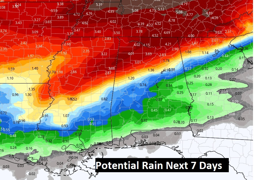
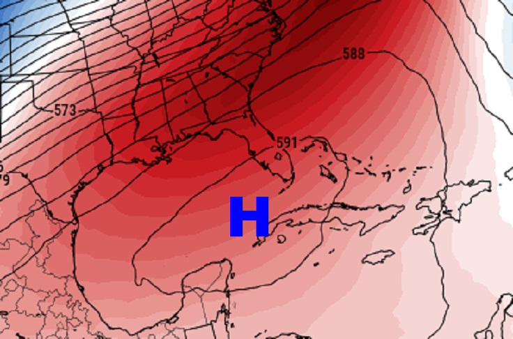
A series of fronts and disturbances will brush by the state this week. But, a very strong sub-tropical upper ridge of high pressure, anchored from the Gulf of Mexico to Bahamas will block the southward extent of the heavy rain corridor. So for much of the week ahead, many of us will be at “The Edge of Wetness”. It’ll be quite warm, with the “Risk” of showers and storm at times Tuesday through Friday.
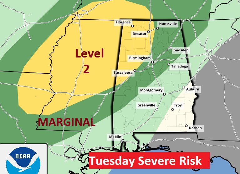
SEVERE RISK TUESDAY: A big chunk of northwest Alabama is in a Severe Weather Risk for Tuesday and Tuesday night. Damaging wind gusts are the main threat. Tornadoes can’t be ruled out. SPC hints at a potential severe weather risk on Thursday. At the moment confidence is low at the moment. We’ll watch it.
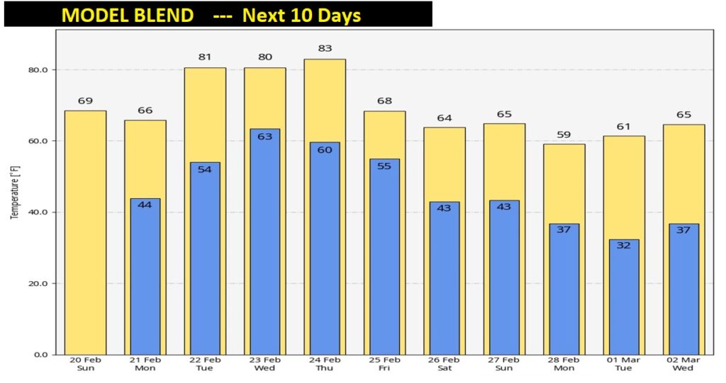
NEXT 10 DAYS: Here’s the blend of all the models, showing temperature trends over the next 10 days. Notice the big mid-week warm-up. 80 degrees or above. Then, a noticeable cooling trend begins Friday and through the last weekend of February and early March. A Potential freeze on March 1st. But, I really don’t see any additional arctic blasts at this point.
SEVERE WEATHER AWARENESS WEEK:
Alabama is no stranger to severe weather, including tornadoes. They can happen any month of the year and any time, day or night. However, we have two distinct severe weather seasons. Our primary severe weather season is considered to be in the spring (March through May). There is also a secondary season that typically runs from the beginning of November until mid-December. The severity of each severe weather season varies from year to year, but it’s imperative that you stay prepared year-round.
The National Weather Service, the Alabama Emergency Management Agency, and other supporting organizations ask for your help in providing the public with information about severe weather safety. Advance planning and increased awareness will help residents of Alabama survive these deadly storms.
In 2021, 65 tornadoes touched down across Alabama. Unfortunately, 7 lives were lost, and nearly 100 were injured. For more information regarding 2021 Alabama tornadoes.
https://www.weather.gov/bmx/outreach_swaw
Have a Great Sunday! I’ll have a complete video in the morning, online by 4:45 AM.
–Rich