3:10 PM UPDATE LANDFALL:
NOAA Doppler radar imagery indicates that the eye of Ian made landfall along the SW coast of Florida near Cayo Costa around 305 PM EDT. Ian’s maximum sustained winds were estimated to be near 150 mph . The latest minimum central pressure estimated 940 mbs. #flwx
10:00AM Update:
10AM UPDATE: EXTREMELY DANGEROUS EYEWALL OF IAN MOVING ONSHORE...
...IAN WILL CAUSE CATASTROPHIC STORM SURGE, WINDS, AND FLOODING SOON... Winds 155 mph (Close to Cat 5). Pressure: 937 mbs. Center now 50 miles SSW of Punta Gorda, moving NNE at 9. Life threatening storm surge up to 18 feet possible. Rainfall of up to 24 inches possible in spots.
9AM UPDATE:
9AM CDT Radar update. Ian’s eye looking perfect. New update from NHC coming up within the hour. Winds still 155 mph. Close to category 5 status. Central pressure 937 Mbs. Extremely Dangerous. Potentially Catastrophic.
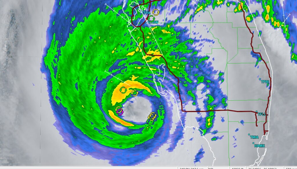
8AM UPDATE:
Oh my gosh! This new update from NHC has a shocking update on the potential storm surge, up to 18 ft. Along part of the SW Florida coast. Ian still with 155 mph wind and a pressure of 937 Mbs. https://nhc.noaa.gov/text/refresh/MIATCUAT4+shtml/281258.shtml…?
EARLY MOIRNING UPDATE:
Good Morning! All eyes on IAN, destined for a Florida landfall later this morning. For us, the news continues good. Here’s my brief video forecast discussion.
TODAY: Get ready for another great Fall Day. Early this morning you’ll need a jacket. Sunshine. Breezy. Low humidity. High in the mid upper 70’s. NW wind 6 to 16 mph, gusting as high as 25. Clear and pleasantly cool tonight. Jackets, again? Low 55. A Red Flag warning is in effect. That means DON’T BURN. Low humidity and gusty winds raises the fire risk. Burning is discouraged.
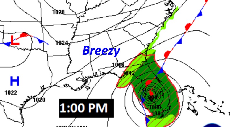
Here’s the Map set-up at 1:00PM All is well here in Alabama. All the drama continues in Florida, Ian will be a big problem through much of the southeastern US coastline for the next several days.
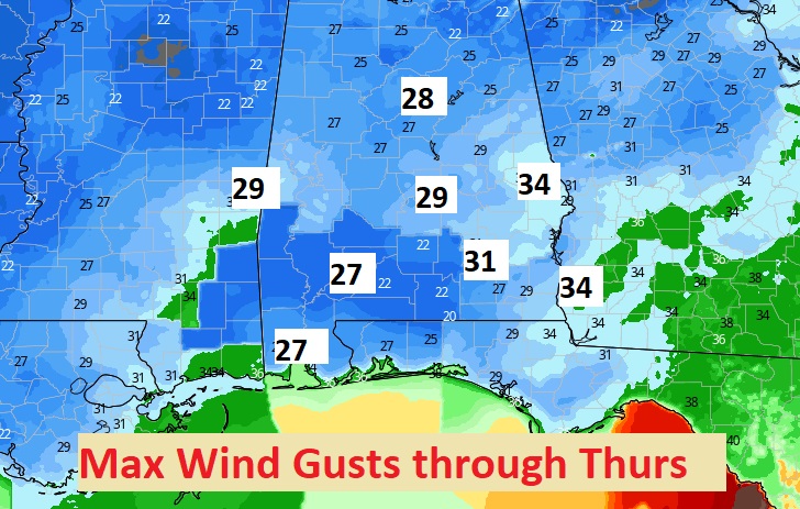
Expect the breezy conditions to continue. Gusts as high as 25 mph today and as high as 30 mph Thursday. Don’t burn. Red Flag warning in effect.
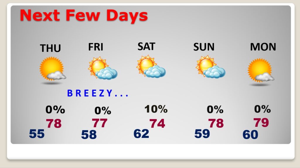
NEXT FEW DAYS: For us, the Great Fall Weather continues through for the next few days. Still, breezy at times. We’re still watching Ian’s exact future track. But, right now I have just about removed the rain chance in for Friday and Saturday. I’ll keep in a 10% chance Saturday. Being on the west side of Ian’s track is good news for Alabama. We’ll be in the 70’s for highs through the weekend. Nights will be pleasantly cool.
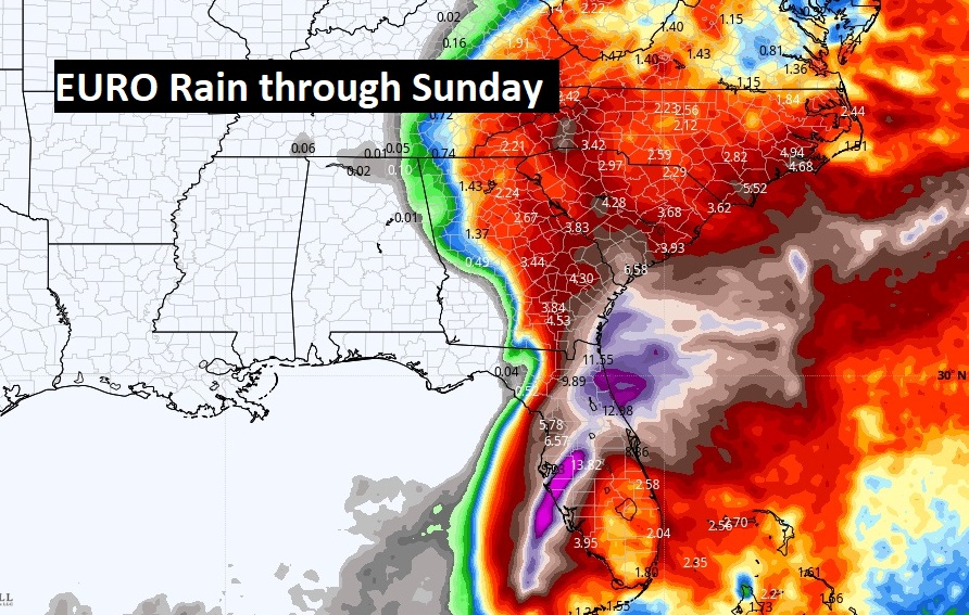
The two biggest global models, the GFS and the EURO, have basically removed the Ian rainshield from Alabama. It looks like we will be dry for the next several days.
TROPICAL OUTLOOK: Monster major hurricane Ian is in the southeast Gulf of Mexico, poised to make Florida today. Probably later this morning. Rapid intensification continues. Winds are now 1140 mph. Cat 4. The central pressure has dropped to 942 mbs. Movement is NNE at 10 mph.
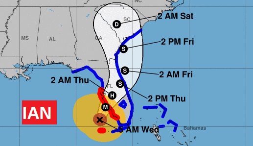
Various Tropical Watches and warnings continue, not only in Florida, but now a tropical storm warning is in effect as far north as Charleston. Ian will have a big impact on much of the southeast United States.
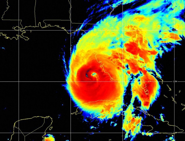
IAN’s satellite looks like a monster on the satellite this morning. Still intensifying. The storm is becoming larger in size.
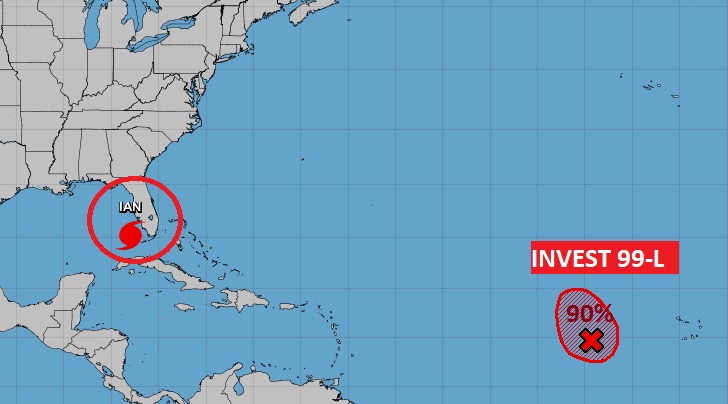
Elsewhere in the Tropics, there’s Invest 99-L in the tropical Atlantic. This system is likely to become a Depression or Tropical Storm Julia soon. There is a 90% chance of development.
Thanks for reading this Blog this morning! This morning we are LIVE on the radio from 6 to 9 on NewsTalk 93.1. Watch us on TV on CBS 8 and ABC 32. I’ll have another update for you in the morning. Have a nice day!
–Rich
