
Good Morning! The Big Chill remains in place. Thanksgiving’s high was only 57. We’ll be near or below freezing at Dawn this morning and again Saturday morning. On this Black Friday, our high will probably only reach the low 50’s. (Normal 66/41) It will be well below normal through Iron Bowl Saturday. Next chance of rain Sunday and Monday, and especially Monday night into Tuesday. No severe weather is expected.
TODAY: Sunshine, chilly. High 54 Clear and COLD tonight. Low 32.

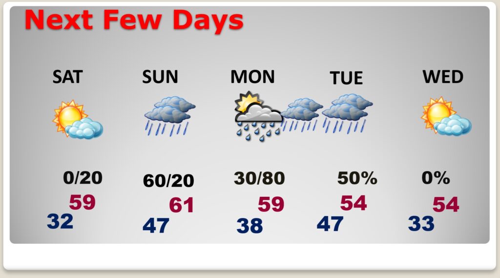
NEXT FEW DAYS:
We’ll be close to a freeze by Black Friday dawn. It will be quite cool though Iron Bowl weekend with Cold nights. (Normal hi/lo 67/41) Next chance off rain Sunday and Monday especially Monday night into Tuesday.

IRON BOWL: The BIG game is in Auburn this year. Kickoff at 6;30PM. The forecast calls for clear, cold conditions, with temperatures dropping through the 40s during the game. Saturday’s high in Auburn 56. Low Saturday night 40.
Thanks for reading this Blog this morning.
I’ll have another update for you in the 4 o’clock hour tomorrow morning. Have a nice Thanksgiving weekend.
–Rich