
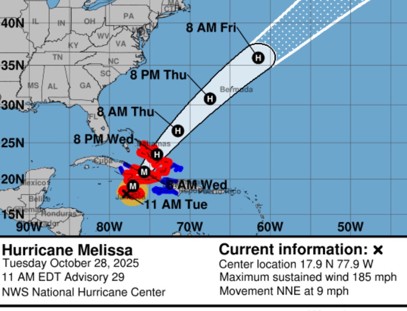
11:00 AM EDT Update 10/28
…EXTREMELY DANGEROUS CATEGORY 5 MELISSA ABOUT TO MAKE LANDFALL IN
JAMAICA…
…CATASTROPHIC WINDS, FLASH FLOODING, AND STORM SURGE OCCURRING ON
THE ISLAND…
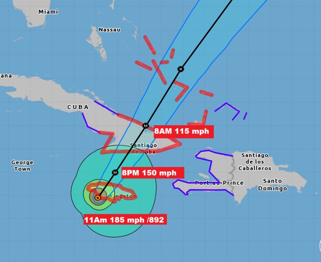
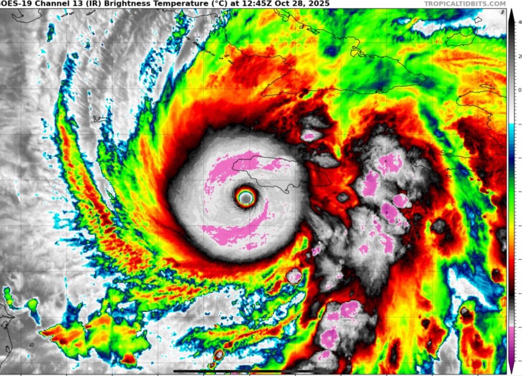
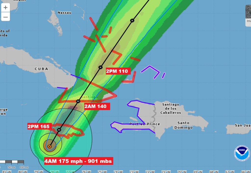
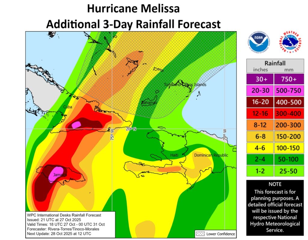
Mellissa 40 SSE of Negril at 11AM EDT (10AM in Jamaica), Winds still 185 mph, pressure 892 mbs., moving NNE at 9 mph. Eye wall is on the coast. Eye will cross the coast soon. Melissa will forever change Jamaica. Rainfall will be measured in feet. 3 to 4 feet of rain in spots.
1000 AM EDT Tue Oct 28 2025
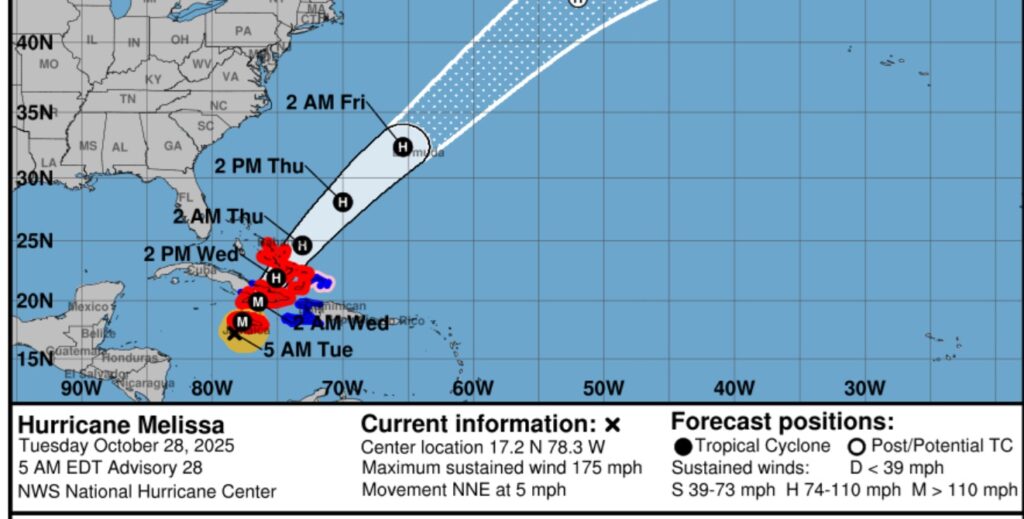
…CATASTROPHIC WINDS MOVING ONSHORE SOUTHERN JAMAICA… …LAST CHANCE TO PROTECT YOUR LIFE… …1000 AM EDT POSITION UPDATE… THIS IS AN EXTREMELY DANGEROUS AND LIFE-THREATENING SITUATION! TAKE COVER NOW! Failure to adequately shelter may result in serious injury, and loss of life. Residents in Jamaica that experience the eye should not leave their shelter as winds will rapidly increase within the backside of the eyewall of Melissa. To protect yourself from wind, the best thing you can do is put as many walls as possible between you and the outside. An interior room without windows, ideally one where you can also avoid falling trees, is the safest place you can be in a building. You can cover yourself with a mattress and wear a helmet for added protection. NOAA Hurricane Hunter Aircraft find that Melissa continues to strengthen with maximum sustained winds of 185 mph. The minimum central pressure has fallen to 892 mb (26.34 inches) based on NOAA and Hurricane Hunter Air Force Reserve aircraft data. The next update will be provided with the full advisory package at 1100 AM EDT ). SUMMARY OF 1000 AM EDT…INFORMATION ———————————————- LOCATION…17.7N 78.1W ABOUT 45 MI…70 KM SSE OF NEGRIL JAMAICA ABOUT 255 MI…410 KM SW OF GUANTANAMO CUBA MAXIMUM SUSTAINED WINDS…185 MPH…295 KM/H PRESENT MOVEMENT…NNE OR 20 DEGREES AT 7 MPH…11 KM/H MINIMUM CENTRAL PRESSURE…892 MB…26.34 INCHES
8AM UPDATE:
.AIR FORCE RESERVE HURRICANE HUNTERS FIND MELISSA STRONGER AS THE NORTHERN EYEWALL IS APPROACHING THE SOUTHERN COAST OF JAMAICA… …900 AM EDT POSITION UPDATE… The eye of Melissa is nearing the southern coast of Jamaica and is expected to make landfall within the next few hours. This is an extremely dangerous and a life-threatening situation. Take action now to protect your life! Residents in the Jamaica should not leave their shelter as winds will rapidly increase within the eyewall of Melissa. Remain in place through the passage of these life- threatening conditions. An Air Force Reserve Hurricane Hunter aircraft has found that Melissa is strengthening with maximum sustained winds of 180 mph (290 km/h). Estimated minimum central pressure based on aircraft data has fallen to 896 mb (26.47 inches).
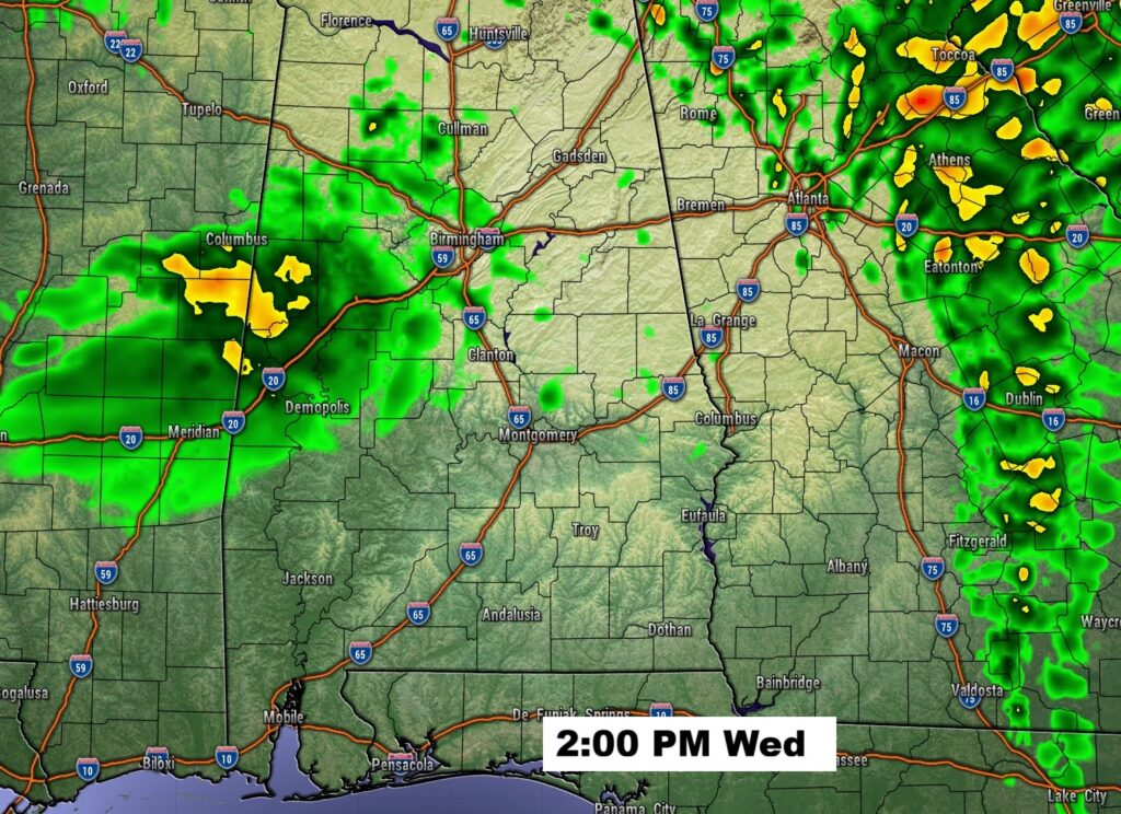
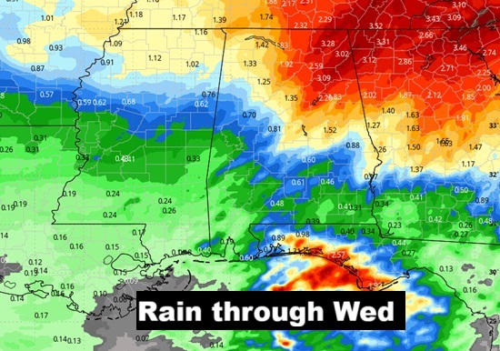
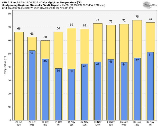
Good morning! Our next weather maker is a cold front that will move across the state overnight hours late tonight into Wednesday, bringing in another decent chance of showers and maybe a few thunderstorms. For a lot of us, the main rainfall window will be from 4AM through about 1PM Wednesday.
Following the frontal passage, get ready for the coolest air of the fall season so far. Thursday’s high will barely reach 60. We’ll be near or below 40 Thursday night and Friday night. Get ready for a quite a chill . Meanwhile this is the landfall day for historic, extremely powerful and dangerous Cat 5 Melissa in Jamaica. A catastrophic disaster is looming. Here’s my Brief Video Forecast Discussion.
TODAY: Patchy fog before 8am. Otherwise, mostly cloudy, with a high near 67. Dry trough the evening hours tonight. Showers likely, mainly after 4am. Mostly cloudy, with a low around 53.
FUTURE RADAR: Main rain threat window from early Wednesday AM until early afternoon.
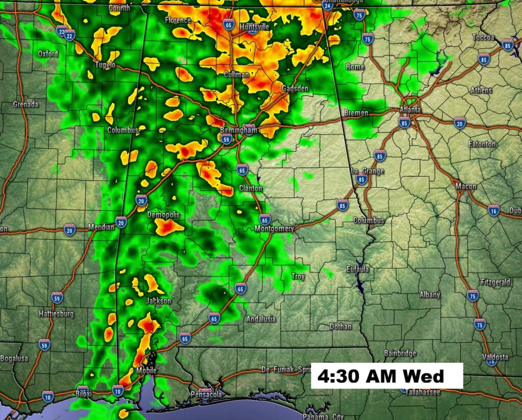
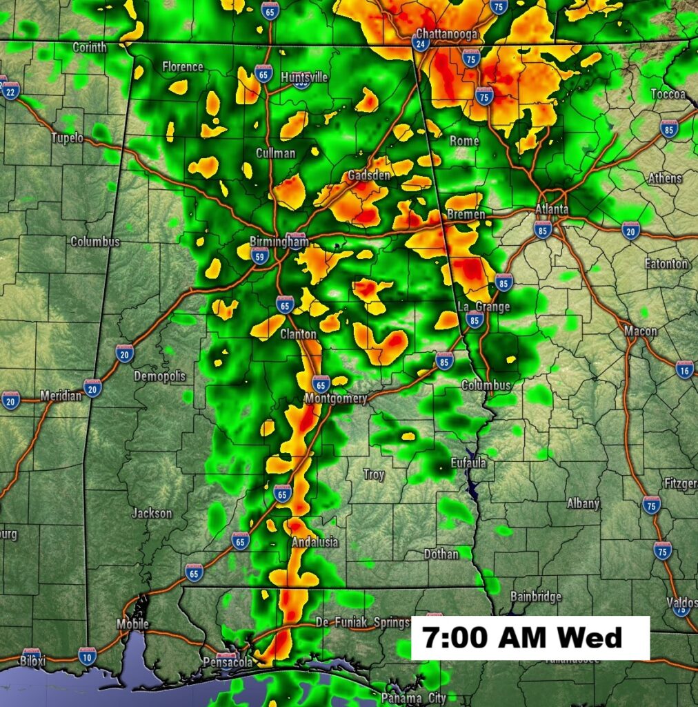
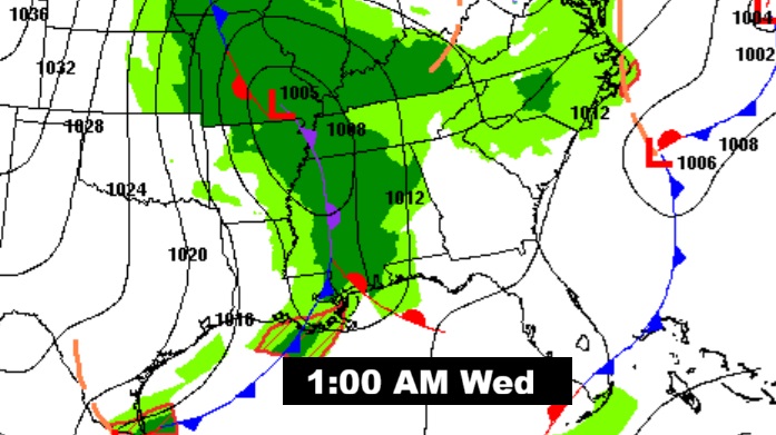
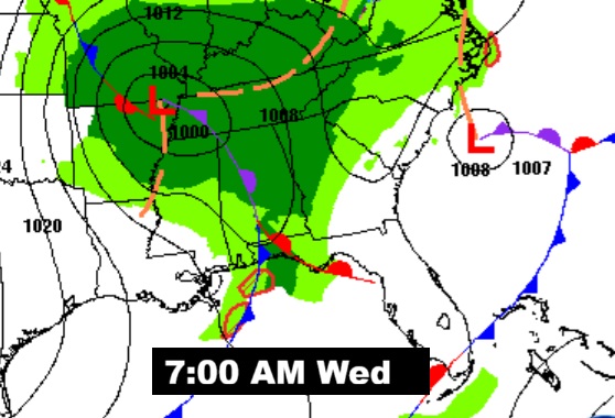
Here’s the movement of the front at 1AM and 7AM Wednesday.
Maybe not much rain with this system, but fingers crossed.
NEXT FEW DAYS: Our next weather maker is a cold front that will move across the state late tonight into Wednesday, bringing in another decent chance of showers and maybe some thunderstorms. Following the frontal passage, get ready for the coolest air of the fall season so far. Thursday’s high will barely reach 60. We’ll be near or below 40 Thursday night and Friday night.
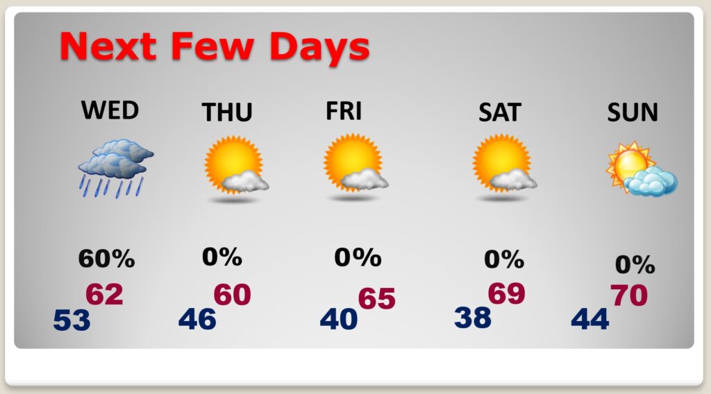
Here’s the 10 Day model blend temperature trend. Big chill ahead.
Hurricane MELISSA UPDATE:
This is the landfall day for historic, extremely powerful and dangerous Cat 5 Melissa in Jamaica. A catastrophic disaster is looming. Hurricane Melissa’s pressure ticks down to 901mb with winds remaining at 175 mph. Melissa is now moving north-northeast directly toward Jamaica. Landfall within the next 12 hours. Reaching eastern Cuba Wednesday AM. Then, accelerating northeast through the Turks & Caicos’ into the SE Bahamas. NHC says: Jamaica: Remain sheltered! Catastrophic flash flooding, landslides, and destructive winds will continue through today,
causing widespread infrastructure damage, power and communication outages, and isolated communities. Total structural failure is possible near the path of Melissa’s center. Along the southern
coast, life-threatening storm surge and damaging waves are expected through the day. Failure to act may result in serious injury or loss of life.
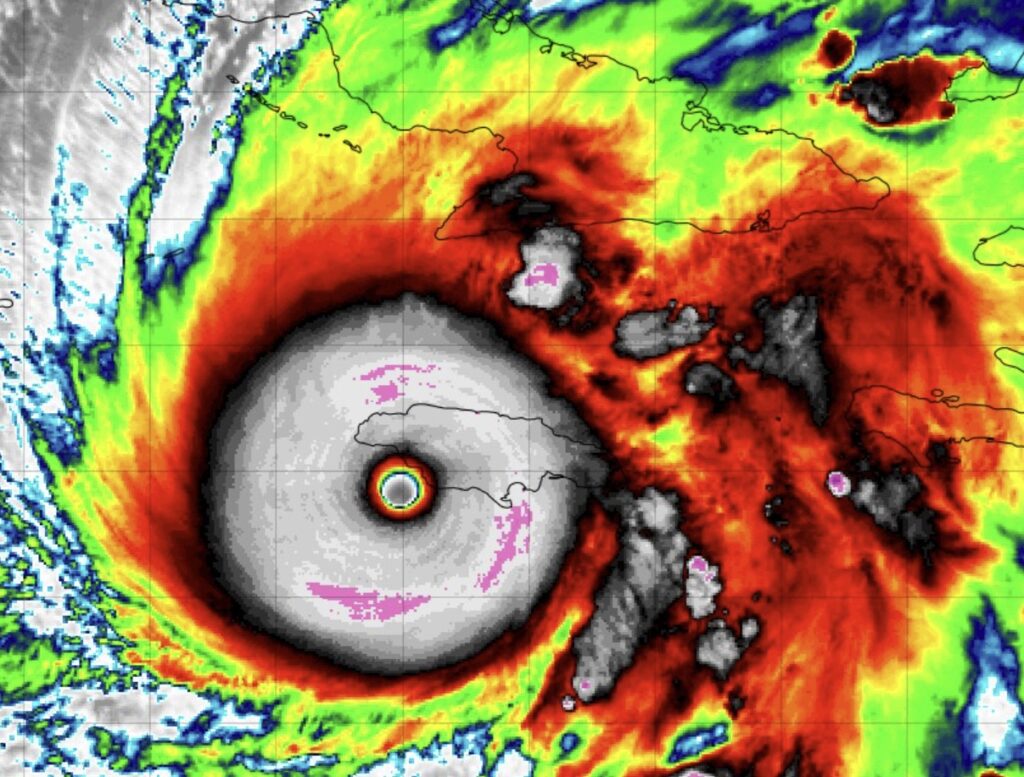
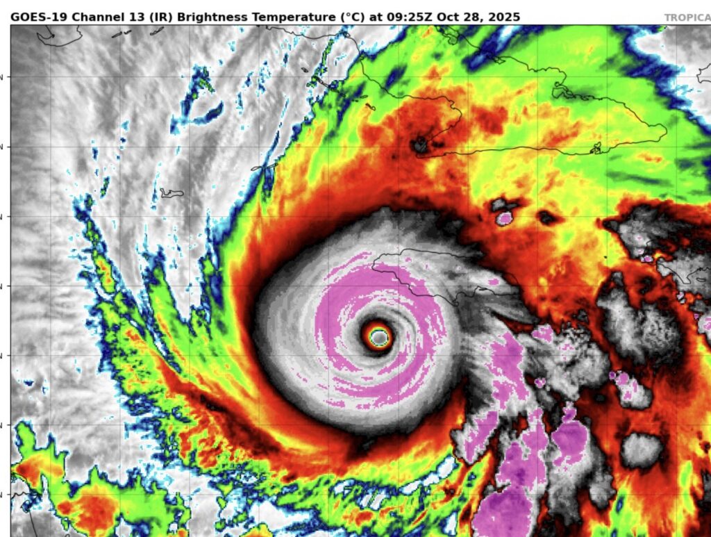
Monster Melissa south of Jamaica as seen from the Goes 19 satellite.

Rainfall will be measured in feet. Unprecedented. Maybe up to 40 inches in spots.
.
Thanks for reading this Blog this morning. This morning we are LIVE on the radio from 6 to 9 on NewsTalk 93.1. I’ll have another update for you in the 4 o’clock hour tomorrow morning. Have a nice day.
–Rich