
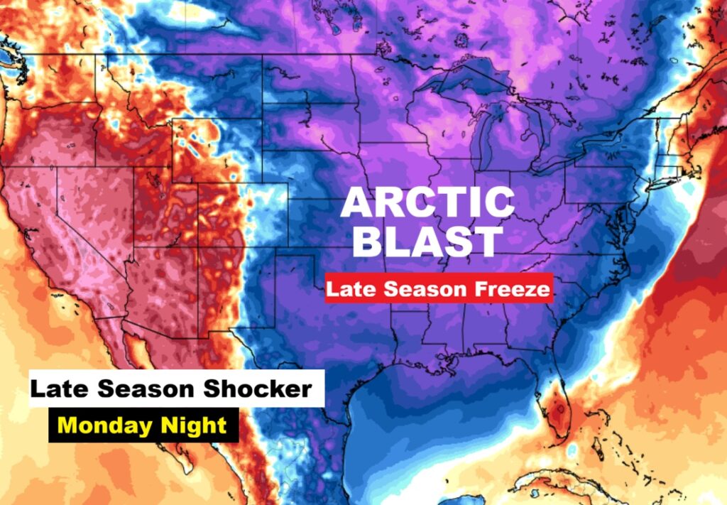
Good Morning! After a very stormy night across our state, get ready for a rather wild temperature ride for the next several days. A cold front will exit the state this morning. The risk of showers ends early. Expect a windy, much cooler day today by roughly 25 degrees. In fact, we’re headed for the upper 30’s by Dawn Friday. Expect a significant weekend warm-up before the next big plunge. Upper 70’s Saturday. Maybe lower 80’s Sunday. Then, a cold front will bring another round of showers and storms by Sunday night. Get ready for a late season shocker as Arctic Air funnels into the state Monday. Highs Monday and Tuesday only in the 50’s. And, there’s a very good chance of a late season freeze by dawn on St. Patrick’s Day Tuesday. A wild ride is in our future. Here’s my brief video forecast discussion.
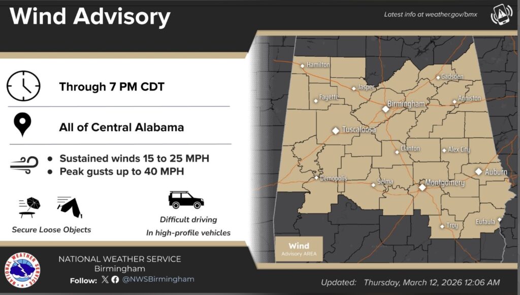
TODAY: Wind Advisory till 7PM. Risk of leftover showers early. Cloudy through mid-morning, then gradual clearing, with a high near 61. Windy, with a north wind around 20 mph, with gusts as high as 35 mph. (Normal 71/46)
TONIGHT: Clear and much colder. Low 38.
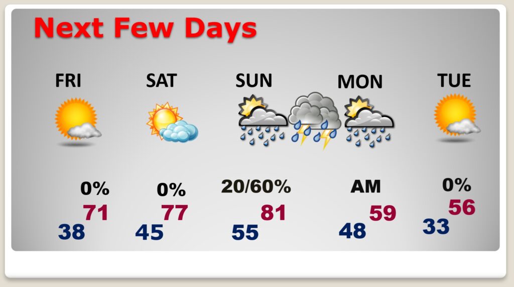
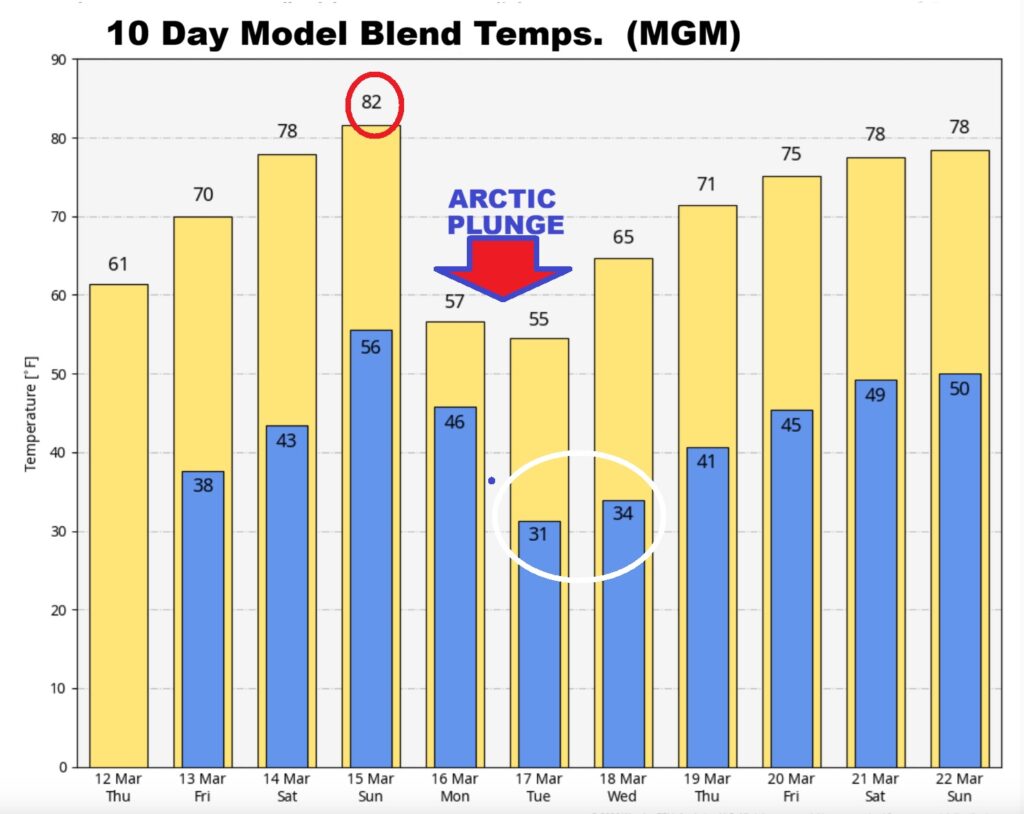
NEXT FEW DAYS: Wild times ahead. Temperature Rollercoaster. Expect a significant weekend warm-up before the next plunge. Upper 70’s Saturday. Maybe lower 80’s Sunday. Then, a cold front will bring another round of showers and storms by Sunday night. Then, get ready for a late season shocker as artic air funnels into the state Monday. Highs Monday and Tuesday only in the 50’s. And, there’s a very good chance of a late season freeze by dawn on St. Patrick’s Day Tuesday.
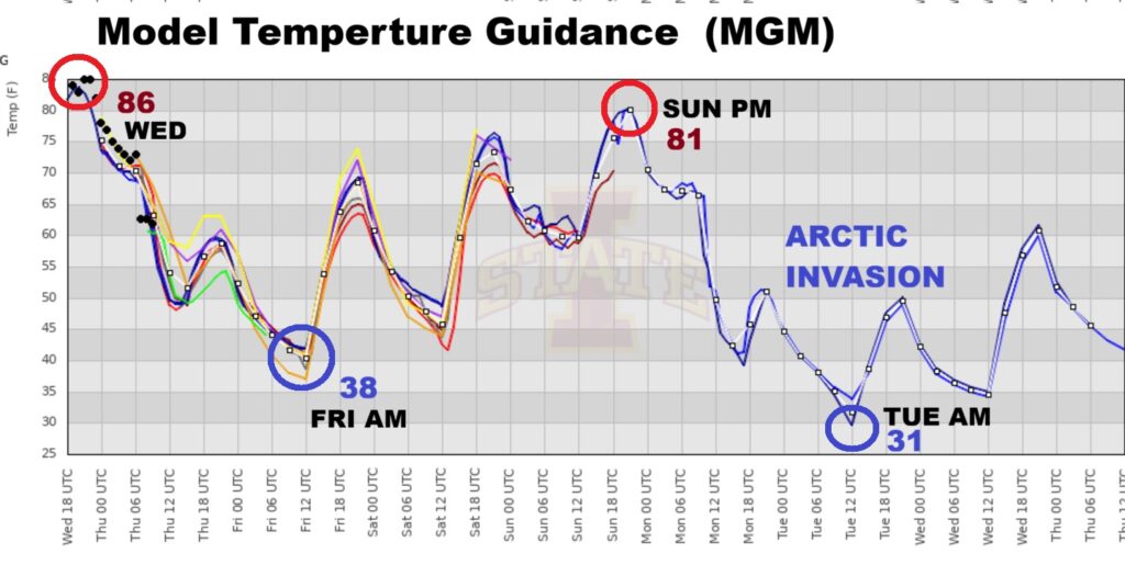
ARE YOU READY FOR A WILD RIDE? Temperatures are going to be all over the place over the next five days. A 55 degree temperature span from 86 Wednesday PM to a sub-freezing 31 St. Patrick’s Day morning. Winter is not done with us yet! Monday and Tuesday’s highs will only make it to the 50’s.
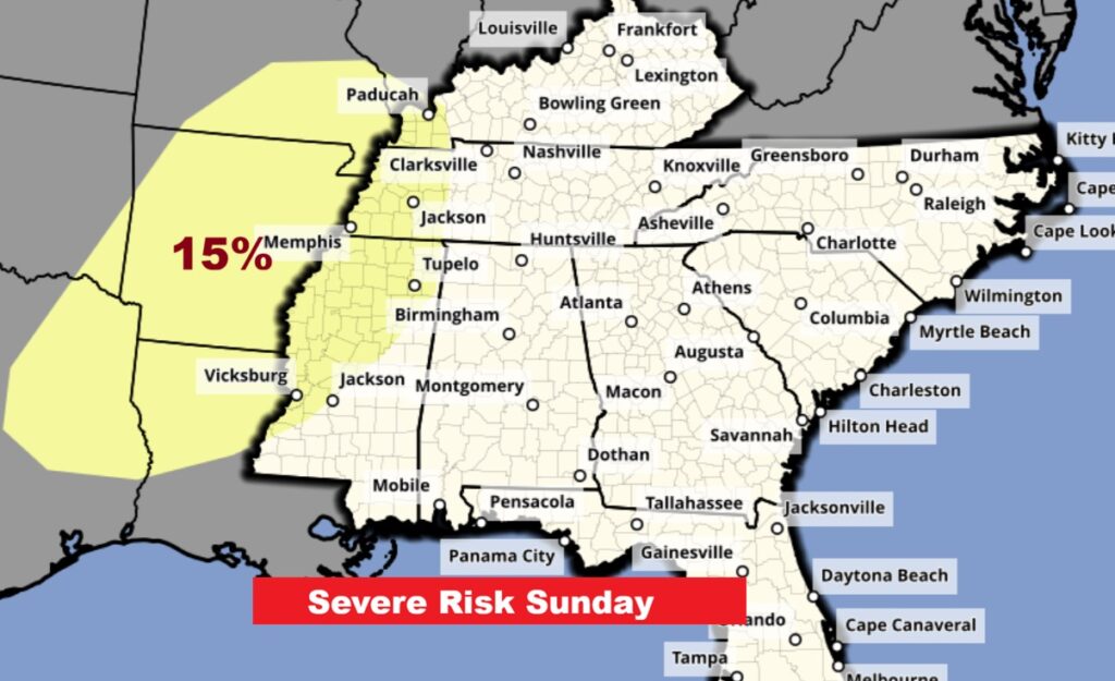
We note with interest the SPC Day 4 Sunday Severe Outlook showing the 15% risk area over parts of MS. Will there eventually be some sort of risk for Alabama Sunday night. We’ll see.
The 10 Day model Blend Temperature Trend. Talk about a roller coaster ride! Lots of ups and downs. St, Patrick’s morning freeze is a good bet.
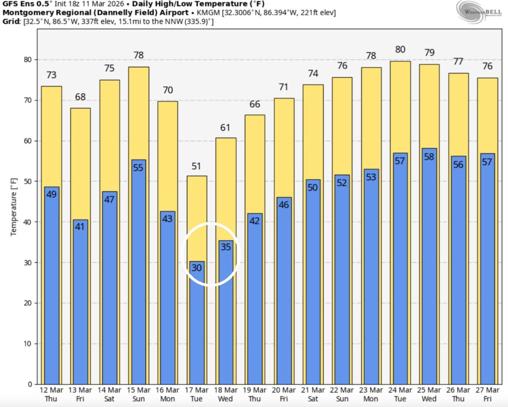
Here’s the GFS Ensembles 16 day guidance. The GFS is even colder for Monday/Tuesday.
The Arctic Blast early next week will be a shock to the system to many.
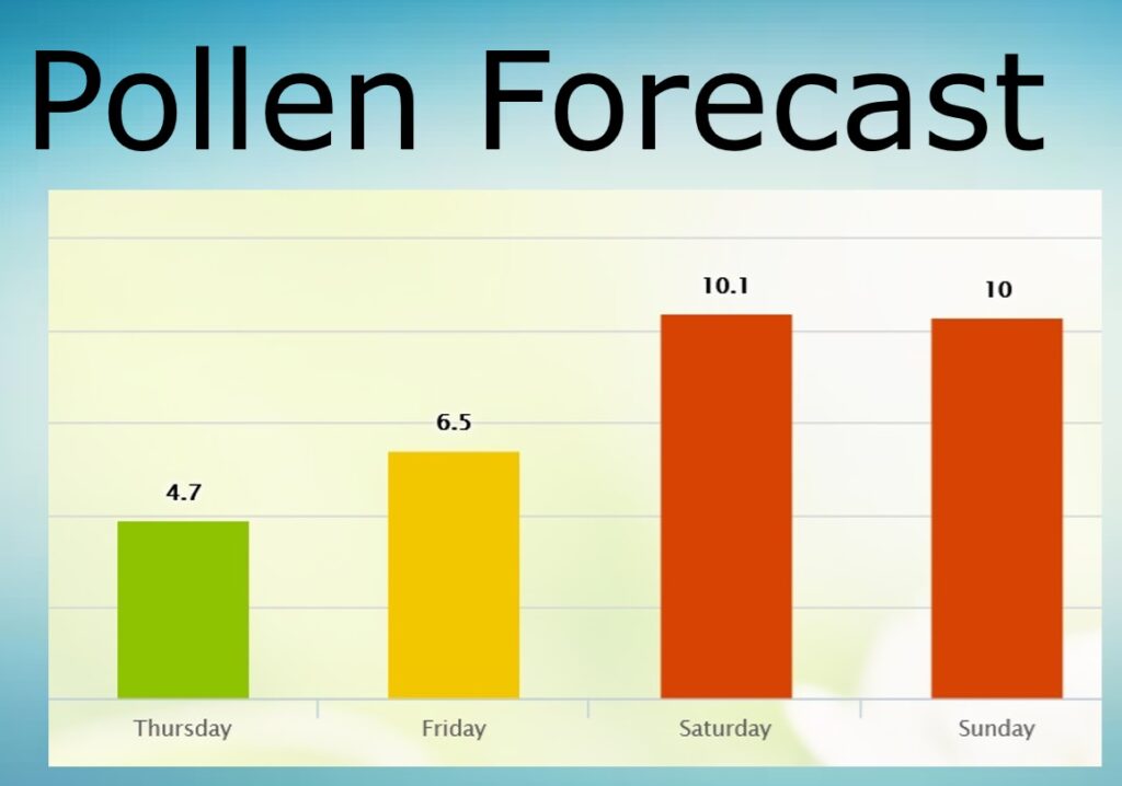
POLLEN FORECAST: We get just a little break today….and tomorrow.
Super Storm of the Century 33rd Anniversary
Thirty-three years ago, it was the start of The Storm of the Century. Truly a perfect storm set-up, it was one of the largest, most intense, and largest death toll winter storms in US History, certainly of the 20th century. I think we all have some pretty incredible memories and stories about this storm.
The set-up for a mega-storm was text-book perfect. Even 4 days before the storm, computer models were forecasting a Mega-storm.
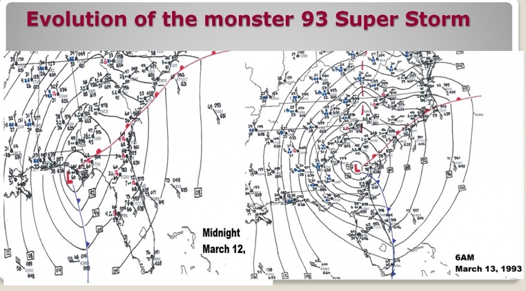
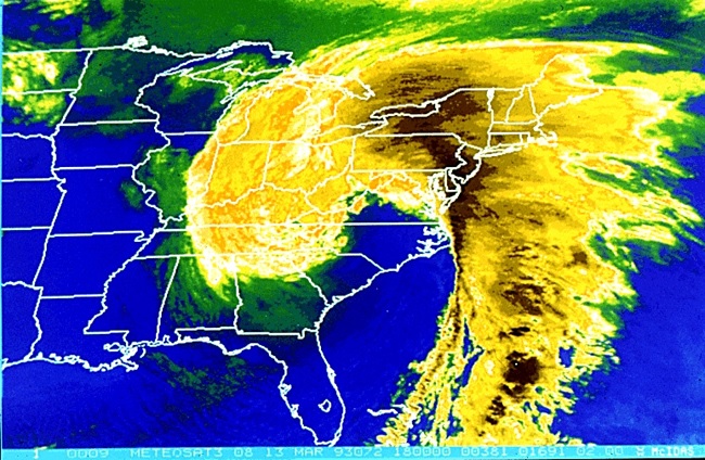
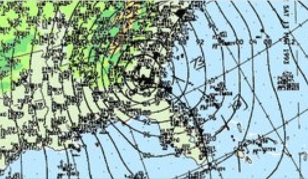
On Friday morning, March 12, 1993, Low pressure off the Texas coast was deepening rapidly and tracking east. By 6PM Friday evening, the low was south of Mobile. By Midnight it was near Panama City and growing stronger. A powerful super storm was centered over south Georgia on Saturday morning at Dawn, March 13th. It brought the first widespread blizzard conditions to much of the southern states in history. All 67 Alabama counties had snow cover, for the first time in modern history.
The storm then headed for the middle Atlantic coast with the strength of a category 3 hurricane. Lowest pressure near the eastern shore of Maryland reached an incredible 960 millibars.
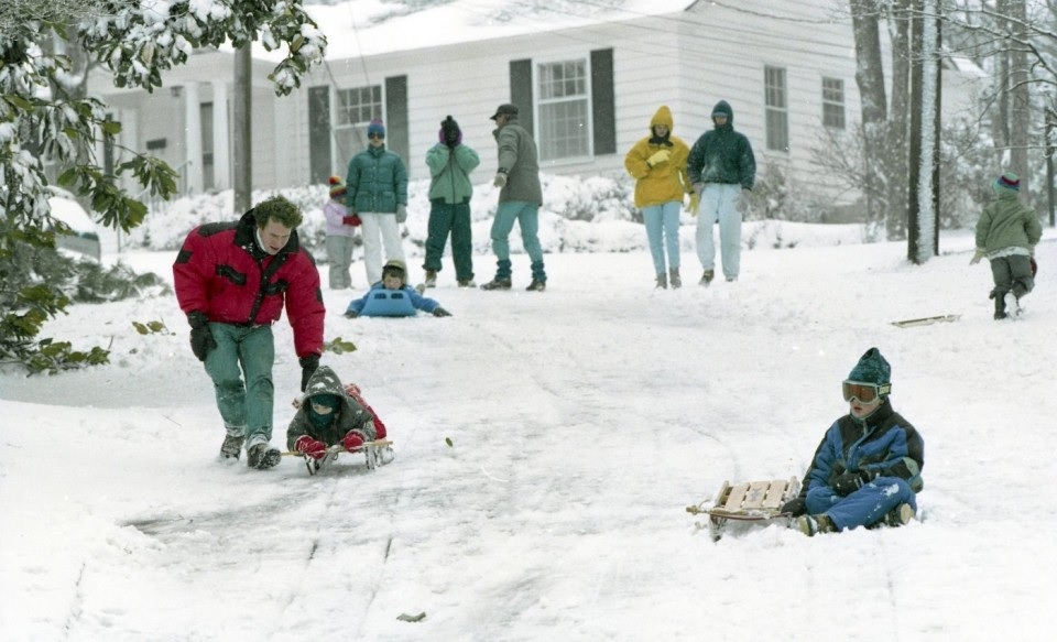
In central Alabama, heavy rain on that Friday night, turned to heavy sleet, then heavy snow, including rare thunder-snow. There was a lot of eerie green lightning, too. Winds gusted to 40, 50 even 60+ mph in spots. Many records were broken at Montgomery, including highest sustained winds, wind gusts and lowest station pressure. Although the official Montgomery snowfall was 4 inches, drifts were a few feet high. There was a band of higher 6”+ accumulations from Evergreen to Camden to Highland Home. Even north Florida had 4” down to the Beach!
The Birmingham area was paralyzed by 13- 16” of snow. Many folks were stranded in their homes for several days. No power. Farther east, North Georgia had up to 35”.
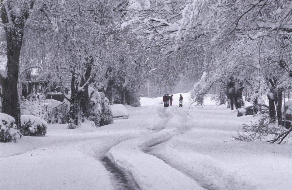
ALL 67 counties in Alabama had a snow cover. Very rare, indeed. Here is some snow totals:
20 inches at Walnut Grove
17 inches at Valley Head
16 inches in Oneonta and Bessemer
13 inches at Anniston, Talladega, Pinson, Birmingham
12 inches at Thomasville, Childersburg, Scottsboro
11 inches at Sylacauga
10 inches at Cullman, Clanton and Heflin
9 inches in Thorsby
8 inches in Ashland, Centreville, Moulton and Guntersville
7 inches in Alexander City, Huntsville and Whatley
6 inches in Camden, Evergreen, Jasper, Livingston, Andalusia, Haleyville and Highland Home
5 inches in Auburn, Winfield, Muscle Shoals and Chatom
4 inches in Montgomery, Union Springs, Vernon, Tuscaloosa, Demopolis, Frisco City, Greenville, Troy
3 inches at Brewton, Hamilton, Bay Minette, Mobile Airport
2 inches at Atmore and Robertsdale
*These snow amounts do not count the drifts. Drifts reached 5 to 6 feet high in spots.
In Florida , the night of the 12th, a killer storm surge took several lives in the Florida Gulf Big Bend area, when the high t1de swallowed several homes. A swarm of 11 tornadoes in central Florida took 25 lives.
Airports were closed all along the eastern seaboard, and flights were cancelled or diverted, thus stranding many passengers along the way. Every airport from Halifax, Nova Scotia to Tampa, was closed for some time because of the storm. Highways were also closed or restricted all across the affected region, even in states generally well prepared for snow emergencies.
Record cold temperatures were seen across portions of the south and east of the US in the wake of this storm. In the United States, the storm was responsible for the loss of electric power to more than 10 million households. An estimated 40 percent of the country’s population experienced the effects of the storm[ with a total of 208 fatalities, making it one of the deadliest winter storms of the 20th century.
..and it all began 33 years ago today.
Thanks for reading this Blog this morning. This morning we are LIVE on the radio from 6 to 9 on NewsTalk 93.1. I’ll have another update for you in the 4 o’clock hour tomorrow morning. Have a nice day.
–Rich