
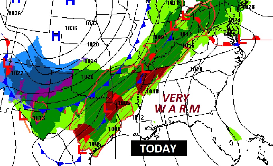
Good Morning! Our extended storm-free pattern continues for one more day today. We’ve been teasing and breaking high temperature records for several days. Yesterday’s high of 87 fell just short of the record of 89. Today I have us close to 89. But, get ready. Big changes are on the way. That massive storm system that has been terrorizing several of our neighboring states to the north and northwest, is edging our way. A vigorous band of strong to severe storms will enter our state perhaps pre-dawn Sunday and march eastward. The Storm Prediction Center has much of the state in a Level 2 out of 5 Severe Risk. Damaging wind gusts to 70 mph and isolated tornadoes are possible as the powerful line of storms moves east. The risk of rain will move out Sunday night. MUCH cooler air will follow. Monday’s high of 64 will be about 25 degrees colder than today. Nights will be very chilly indeed. By Dawn Wednesday we may bottom out in the upper 30’s. A significant change of climate.
TODAY: Partly sunny, becoming windy and unusually warm. High 89. (Today’s record of 91 from 1988 is probably safe) South wind at 10 to 15 gusting to 25 mph. Dry through the evening hours tonight. And probably dry through most of the overnight hours. Unusually Mild. Low 70.
The massive storm system which has been stuck, battering the same states for days will finally, slowly start to edge eastward. Today the greatest risk of Severe Weather and tornadoes will be in that Enhanced Level 3 Risk from western Tennessee to Louisiana.

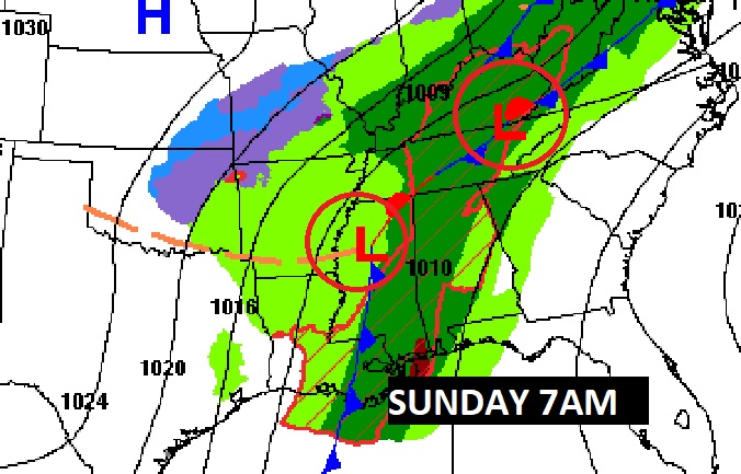
By 7AM Sunday, notice how the risk reaches the far western counties of Alabama.
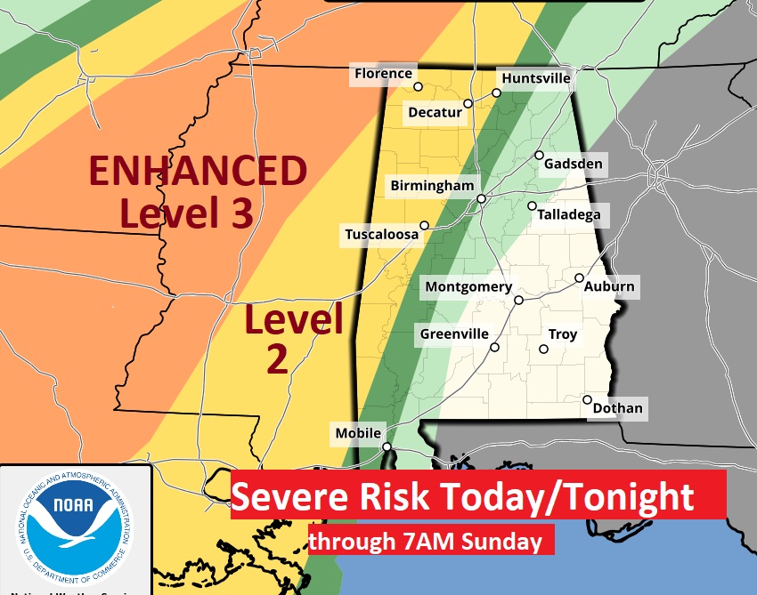
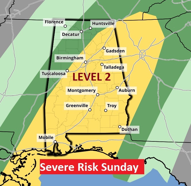
SUNDAY: A vigorous band of strong to severe storms will enter our state perhaps pre-dawn Sunday and march eastward. The Storm Prediction Center has much of the state in a Level 2 out of 5 Severe Risk. Damaging wind gusts to 70 mph and isolated tornadoes are the main risk as the powerful line of storms moves east. Frankly, I thing the tornado risk is on the low end, but certainly NOT zero. Large hail is also possible. Sunday’s high 79.
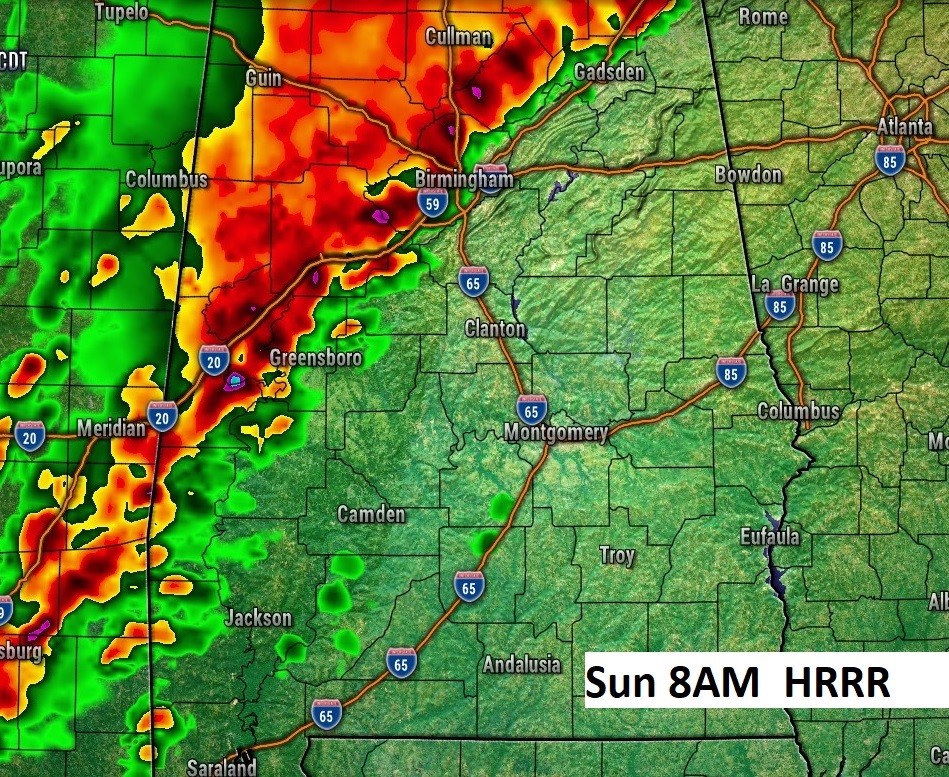
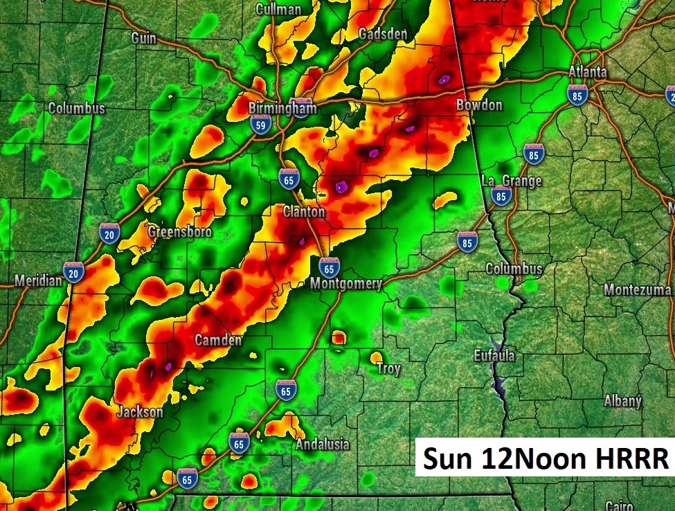
HI RES-FUTURE RADAR: I’ve selected some Future Radar examples from the latest model runs to give you a sense of how tomorrow could play out. Notice the “squall line” (QLCS) in west Alabama in the morning, shifting closer to the I-65 corridor by lunchtime and then, perhaps not quite as impressive as it moves into southeast Alabama later in the afternoon.

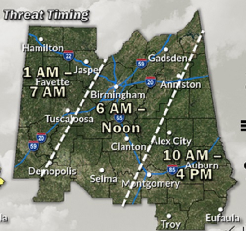
Here’s the updated timing map from NWS. For most of us the greatest threat is morning and mid-day.
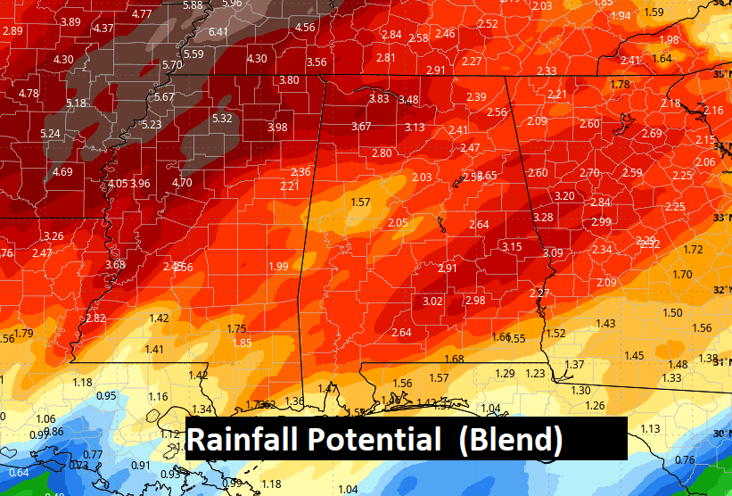
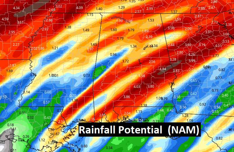
A new wrinkle, with this approaching storm system, beyond the Severe Weather Threat Potential. Some of the models are starting to indicate, more and more, the potential for excessive rainfall as this system tends to stall somewhere over the area. An area wide FLOOD WATCH has now been issued. #alwx
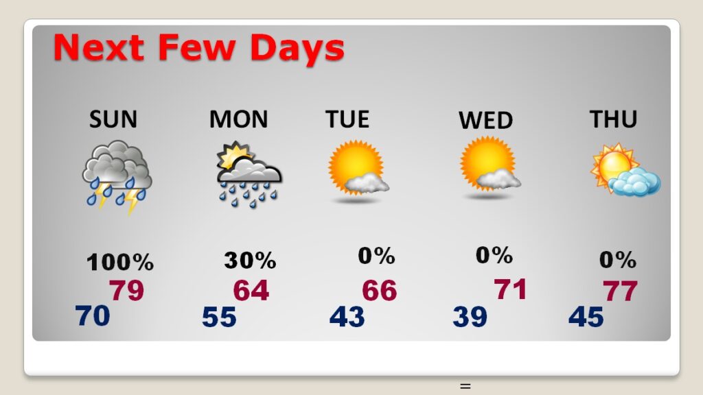
NEXT FEW DAYS: Stormy Sunday with the Severe Risk, ending Sunday night. Then, MUCH cooler. A huge change of climate Monday and Monday night. Monday’s high of 64 will be about 25 degrees colder than today. (Normal hi/lo is 76/50) Nights will be very chilly indeed. By Dawn Wednesday we may bottom out in the upper 30’s. I have us storm-free all next week.
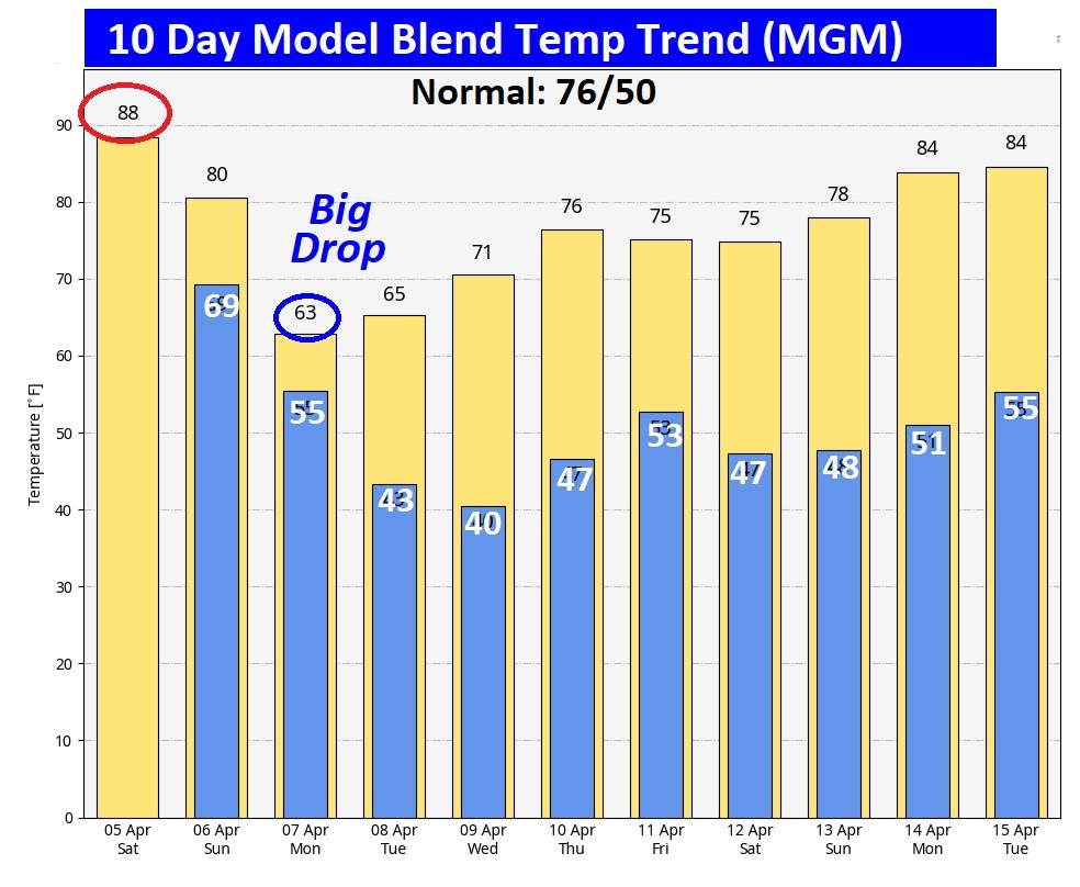
Here’s the 10 Day Model Blend Temperature Trend. Look at the drop from today’s high in the upper 80’s to Monday’s high of 64. Wednesday morning it shows us at 40. Much warmer again by the middle of the month as we tease the middle 80’s again.
Thanks for reading the blog. I’m back in Montgomery this morning following my trip to the National Tropical Weather Conference.Obviously, there will be another Blog update tomorrow morning as Severe Weather approaches. And additional updates as needed. Stay weather aware.
–Rich