
An arctic cold front sweeps across the state tonight. Two nights of freezing temperatures are expected. The current freeze warning covers Tuesday night & Wednesday morning.
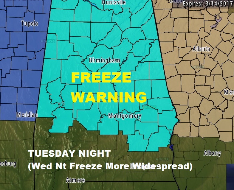
Expected Low by Dawn Tuesday 30-32°
Expected Low by Dawn Wednesday 27-29°
* IMPACTS…Crops and other sensitive vegetation will be damaged.
The growing season has started earlier than normal due to unseasonably warm temperatures.
PRECAUTIONARY/PREPAREDNESS ACTIONS…
A Freeze Warning means sub-freezing temperatures are imminent or highly likely. These conditions will kill crops and other sensitive vegetation.
**Please don’t forget to bring your pets.
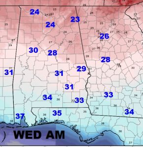
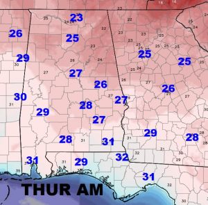
Here are the projected lows for near Dawn on Wednesday and Thursday morning. Notice the colder readings on Thursday. The freeze warning will have to be extended, probably through the extent of south Alabama for Wednesday night into Thursday morning.
DAYTIME HIGHS will be very cold, too. In fact, it will feel more like January. Highs on Tuesday will be in the mid 50’s, but strong northwest winds 10-20 gusting as high as 35 will make it seem colder. Wednesday’s high will struggle to reach 50. Thursday will not be quite as cold, with a high of 57. The normal high as low is 69 and 45. Recovery begins Friday.
RAIN TONIGHT: Showers will increase across the area this evening, becoming widespread, along the arctic cold front which crosses the state overnight. Low tonight 42.
I’ll have more details for you in your next video tomorrow morning, which will be online by 5. Have a great evening.
-Rich