SEVERE RISK UPDATED (3:45PM 4/13/18)
GREAT Update from NWS Birmingham I want to share. I’ll have much more for you first thing in the morning)
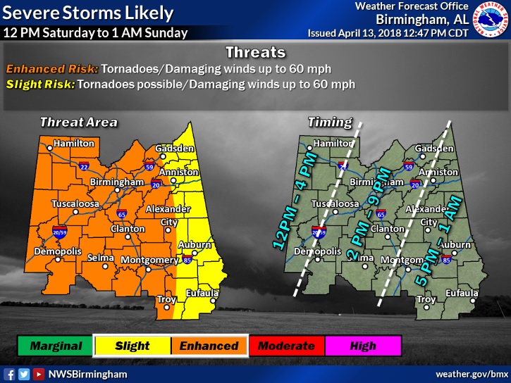
After taking a look at the latest data coming in this afternoon, we’ve decided to increase our severe threat area to Enhanced for much of Central Alabama. In addition, we’ve refined the threat timing, trimming it down from 12PM Saturday in the west to 1AM Sunday morning in the east. That being said, MANY uncertainties remain in this forecast.
WHAT ARE THE UNCERTAINTIES?
1) Timing of the line of storms
2) How much instability will be available as the storms move through
The big question will be how far east this line will move by Saturday morning. Some forecast guidance is hinting at the line moving into northwest Alabama earlier in the day, which would limit severe potential for those locations. However, there is also a chance that line could also slow down, and allow more unstable air to push northward Saturday afternoon. That’s why we’ve gone ahead and upgraded much of the area to an Enhanced Risk, looking at that “worst-case” scenario of more unstable air being available.
COULD THIS FORECAST CHANGE?
Absolutely, in fact we’d like to recommend to everyone to check the latest forecast first thing in the morning to see exactly how this line of storms is evolving. We’ll be watching the evolution of the storms during the midnight shift tonight, and put out the latest forecast graphics likely by 5am Saturday morning.
NOW IS THE TIME TO PREPARE:
No matter which risk area you may be in on the map, you need to be prepared for severe weather. Have your plan in place in case you need to take shelter in the event a warning is issued!