
Today will be relatively quiet, but hang on. Some big weather changes are on the way. A powerful cold front is approaching. Before it’s arrival Sunday night, it appears that much of our state will be dealing with the threat of severe weather, including damaging straight-line winds and maybe a few tornadoes. Then, it turns windy and sharply colder. It will be a rather shocking change as “old man winter” returns for a few days.
TODAY: Patchy fog early. It will be a mostly cloudy day, but there will be some “sun-breaks”. High near 70. Widely scattered showers are possible but they will be very isolated in nature. Tonight’s low upper 50’s.
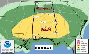
SUNDAY’S SEVERE WEATHER THREAT: On the map, low pressure will track from west central Alabama into north Georgia by evening. The low will drag a cold front southward. A line of strong/severe storms, ahead of the cold front, will carry the threat of damaging wind gusts to 60+ mph and the risk of a few thunderstorms.
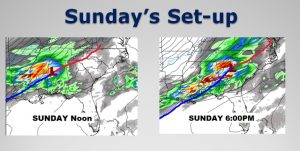
Future Radar snapshots at 4PM, 6PM, and 8PM (Sunday), shows the expected progress of the line of storms. However, individual storms may form ahead of the line, during the afternoon. These types of individual super cell thunderstorms occasionally begin to rotate and produce tornadoes.
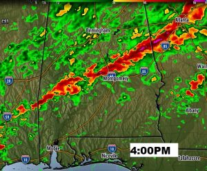
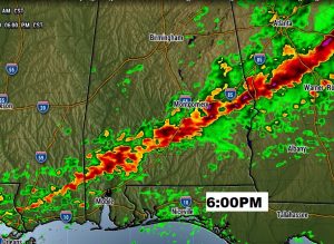
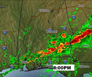
The Storm Predilection Center has a Level 2 Slight Risk covering all of the state roughly from Birmingham southward. Main threats are damaging wind gusts and a few tornadoes. Quarter size hail is also possible in a couple of the storms. The main time window would be from about Noon into the early evening hours, before the threat ends across southeast Alabama closer to 8 or 9PM.
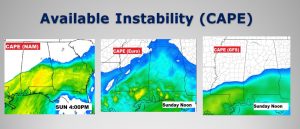
The models still don’t quite agree on the available severe weather ingredients. The most bullish model is the NAM which shows more than sufficient instability or CAPE. The GFS model is quite a bit tamer. The Euro model is in between the two. Much deepens on the development of the Low and it’s exact track.
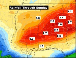
Rainfall amounts will be in the 2 to 3” range in spots.
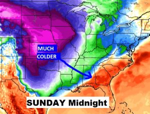
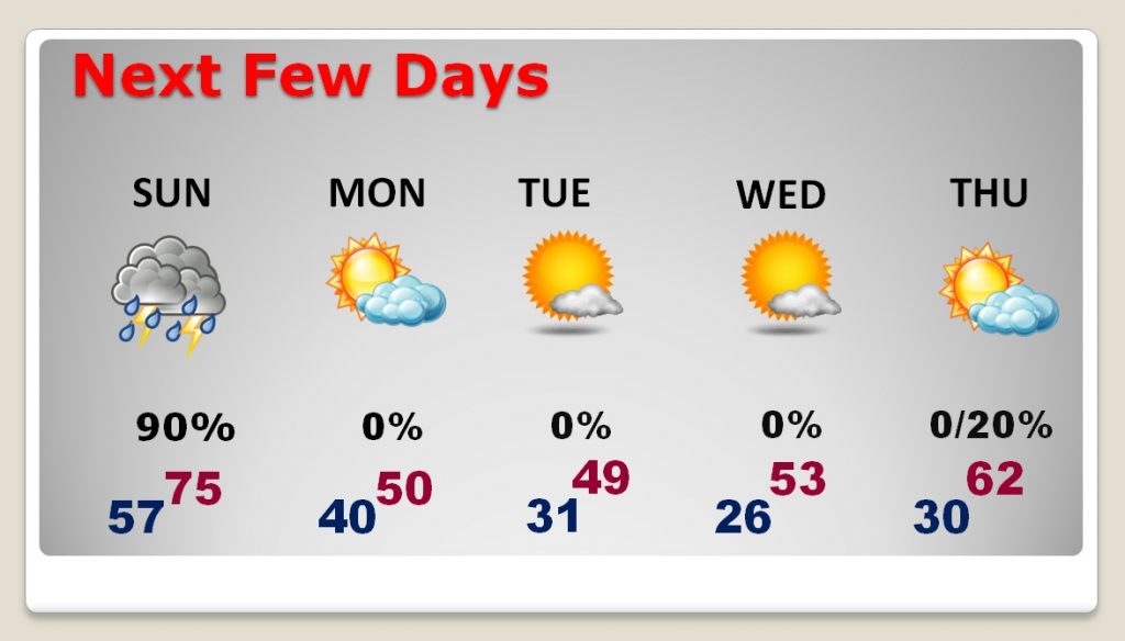
SHARPLY COLDER AIR AHEAD: Late Sunday and Monday it will turn windy and sharply colder. The high Monday will be near 50, and perhaps just shy of 50 Tuesday. We’ll be in the 20’s Wednesday morning. Now would be a good time to plan to take care of tender vegetation which could be affected by the freezing temperatures.
NEXT FEW DAYS: Drastically colder air for a few days Monday through Thursday before some late week improvement, as warmer air returns. The next storm system will affect the area by the end of the week.
– –
I’ll have another blog update on Sunday morning, early, from here in Montego Bay Jamaica, before I get on a plane for my return. Have a nice weekend! Stay weather aware.
-Rich