
Overall, the news for most of us this weekend, is much less concerning than we had feared. Parts of northwest Alabama are on alert for possible severe storms and a tornado threat today and tonight (3PM to 3AM). The greatest threat will remain north and west of the I-20/I-59 corridor, ahead of a slow moving front. The front eases southward, overnight tonight and tomorrow. Thunderstorms will fire up Sunday, and some storms could be strong. We can’t rule out a couple of severe storms in parts of central and southeast Alabama. (maps below). Another strong system could affect us by Thursday.
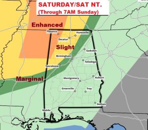
Here’s today Severe Weather Outlook from the Storm Prediction center. The Enhanced Risk area in extreme northwest Alabama could see a “strong” tornado, perhaps.
TODAY: For us, a breezy, warm, spring-like day… Like yesterday, it will be mostly cloudy with a few “sun-breaks”. South winds at 10 to 20+. High in the upper 70’s. Low tonight 65. The atmosphere is fairly “capped”, so it should be mostly dry. Thunderstorms are possible late tonight, mainly after midnight.
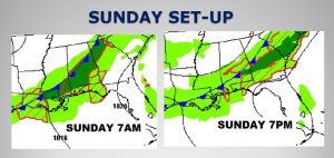
SUNDAY’S STORM SET-UP: The slow moving front will edge southward. Daytime heating will allow showers and storms to develop along and ahead of the front, anytime Sunday, and perhaps a few stronger storms can’t be ruled out. Here’s the frontal movement Sunday/Sunday night into Monday morning.
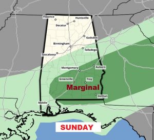
The Storm Prediction Center has much of central & southeast Alabama in a Marginal severe weather risk. The main threat would be damaging wind gusts. There‘s a “non-zero” tornado risk, but the parameters look very weak, and this is nothing like the set-up which caused the tornado outbreak last weekend.
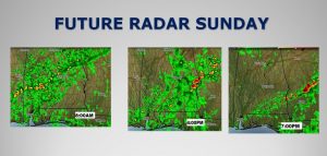
Here’s a few Sunday Future radar snaps shots. The hi-res models are picking up on a few stronger storms popping up during the day, especially in the afternoon.
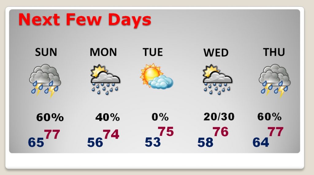
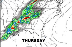
NEXT FEW DAYS: The risk of thunderstorms will be rather high on Sunday, and there could even be some leftover showers Monday. Tuesday looks quiet. The shower threat returns Wednesday and Wednesday night, leading to a storm system Thursday, which once again could bring us some strong storms.
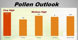
POLLEN FORECAST: Everybody’s talking about the pollen. It’s bad. Like yesterday, the pollen level will be in the extremely high range today, and medium to high range Sunday through Wednesday.
SPRING-FORWARD TONIGHT: This will be the one millionth time someone will remind you that we Spring Forward back to daylight saving time late tonight. (2AM Sunday) Turn your clocks forward one hour. We lose an hour of sleep.
– –
I’ll have another blog update on Sunday morning. Early. Have a nice weekend! Stay weather aware.
-Rich