
It has been a great extended stretch of quiet, storm-free days. Today is Day 10, and the final day. An approaching frontal system will be a round of showers and storms to the state tomorrow. It’s possible there could be a few stronger, potentially severe storms during the afternoon and early evening. Details below.
Another shot of cooler air will follow the front. Much of the rest of the week will be dry until Friday Night/Saturday when the next storm system approaches.
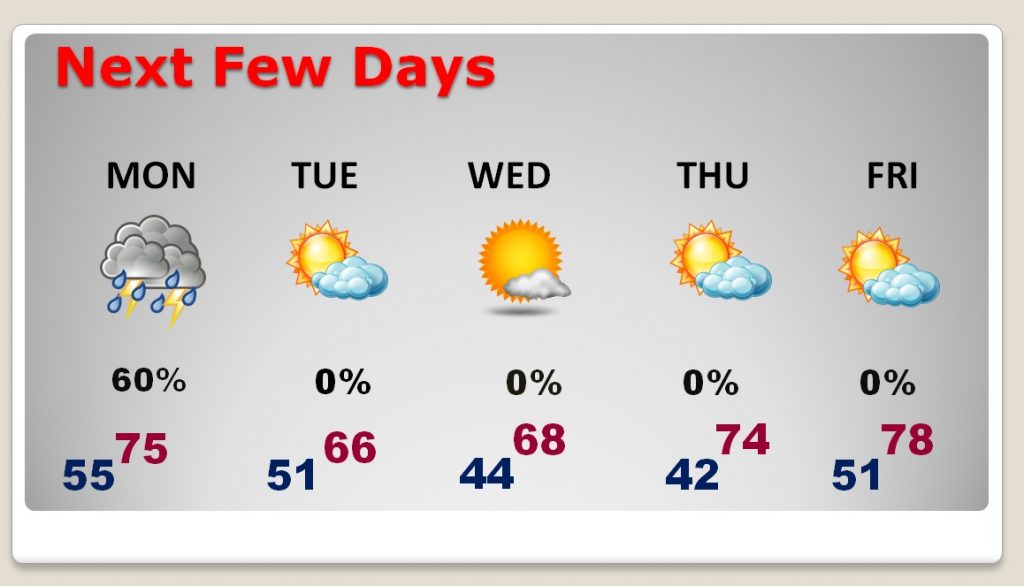
TODAY: Looks like another great day. Abundant sunshine. The warm-up continues. High today near 80. Winds will be light out of the south. Increasing clouds, but dry tonight. Not as cool. Low 54.
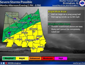
MONDAY’S SEVERE RISK: The frontal system approaching the state tomorrow, will arrive at the right time, tomorrow afternoon, to work with some “juicy” air. A few super-cell thunderstorms are possible. Damaging wind gusts up to 60 mph and large hail, up to ping pong size will be possible in the stronger storms. The tornado threat in this situation is very low. The greatest risk window will be from 1:00 to 8:00 PM. All of central and much of south Alabama are included in then higher risk zone.
NEXT FEW DAYS: After the Monday storm system, cooler air is on tap Tuesday & Wednesday with highs in the 60’s. The two coolest mornings will be Wednesday and Thursday, with lower 40’s It will warm up Thursday and Friday, well into the 70’s. Storm system arrives by Saturday.
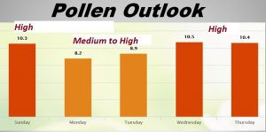
POLLEN FORECAST: The pollen count continues in the very high range today. It will be a notch or two lower Monday and Tuesday, before returning to the high range later in the week.
—
I’ll have a complete video update Monday morning. I’ll have more details of the potential for strong storms Monday afternoon & evening. Have a great day today.
–Rich