
Good Morning! I’m on the road this morning. This is just a forecast update. There are no wholesale changes. Today will be the last in a string of warm/dry days. The storm system on the way will bring showers and storms to the area by late Thursday and Thursday night. Although some parts of our state could see strong/severe storms, this does not appear to be a severe weather situation for most of us. And, wait till you see the details of our beautiful weekend forecast!
TODAY: Cloudy at times, mixed with filtered sunshine. Warm. Dry. High near 84. Southwest wind at 6 to 12 mph. Mild tonight. Low near 60.
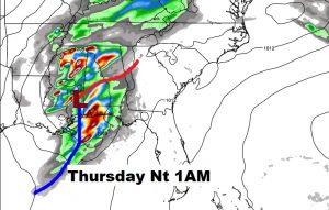
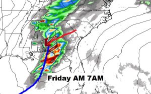
LATE WEEK STORMS SYSTEM: Simply put, the approaching storm system will have a southerly track. This will, generally keep the stronger thunderstorm threat closer to the coast. We like that. Here’s the EURO model trend for Thursday night/Friday AM.
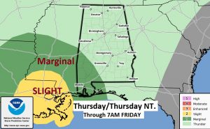
The Storm Prediction Center keeps a Marginal Severe Risk into southwest Alabama Thursday evening/Thursday night, through 7AM Friday AM.
THE NEXT FEW DAYS: After the storm system departs, we have a text book perfect weekend forecast!

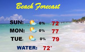
BEACH FORECAST: Stormy Friday! But, then, get ready for a really nice weekend. The Gulf water is till chilly.
—
Hope you have a great day today. Everything is back to normal tomorrow, The next video will be online by 4:45AM Thursday. Enjoy another