
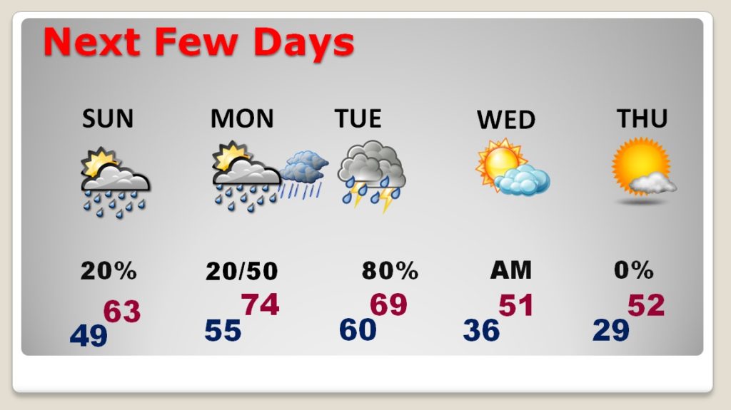
Good morning! After a foggy start this morning, we should have a dry, cloudy, mild day ahead. The weather should cooperate in a big way for various Christmas festivities today in places like Millbrook, Tallassee, Luverne, Tuskeegee, Demopolis…just to name a few. Rain chances are under 20% today and close to 20% tomorrow. But, on the Blog update we’ll talk about a very active week ahead. Big changes are on the way.
The Dense Fog Advisory for this morning was cancelled…
TODAY & Sunday: We have a nice day underway. Sun & cloud mix. Clouds increasing later. Should be dry. Today’s high 64. (Normal 62) Low tonight 49. (Normal 39). SUNDAY will be cloudy. An isolated shower is possible (20% Chance). High 63
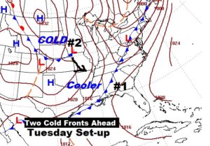
BIG CHANGES THIS WEEK – Two Cold Fronts: Warm Monday, with mid 70’s. Showers and thunderstorms move in Monday night into Tuesday ahead of Cold Front number one. No severe weather is anticipated. Then, the second cold front, will deliver a Big Temperature plunge for mid week. Wednesday & Thursday’s highs will be about 25 degrees colder.
Here’s the Tuesday set-up: The first front arrives daytime Tuesday.. The second front arrives overnight Tuesday night. Much colder behind the second front.
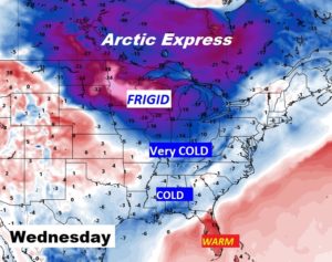
MUCH COLDER AIR : Harsh Arctic air is coming into the United States. The heart of the Arctic Air will stay well north of US. So, while we will be much colder, we will only sample this latest “Arctic Chunk”. Frigid air will miss us, this time.
NEXT FEW DAYS: Comfortable Sunday, with only a tiny rain chance. Warm Monday. Showers and thunderstorms Monday night and Tuesday. Mild Tuesday, before much colder air arrives by Tuesday night and through mid week. It will be a BIG change. More rain arrives at the end of next week.
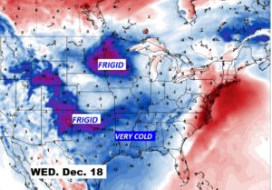
MULTIPLE SHOTS OF COLD AIR: Over the next couple of weeks or so, we will see multiple shots of COLD air. Here’s one more snapshot. This is the GFS model showing some pretty cold air covering much of the nation on Wednesday, December 18th. If this verifies, it would be COLDER than the airmass we will experience this week. A bigger sample of Arctic Air.
—
Have a great Saturday! Enjoy the Parades and Tree lightings.
-Rich