Good morning! The news is good on this Sunday morning. Today will be yet another good day – dry & quiet, with a warming trend. But, all eyes are on that Monday evening Severe Weather Threat, ahead of a strong cold front. Another big Temperature Plunge will follow the front, and we’ll see at least a couple of sub-freezing mornings, before we recover later in the week.
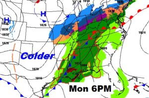
Here’s the Map set-up for Monday evening…

TODAY: Get ready for pretty nice day, today. I’ll be optimistic. I think we’ll see a sun/cloud mix, with more clouds then sun. Normal high is 60. Today I think we’ll make the upper 60’s. Mild tonight. Low in the mid 50’s. 20% chance of a shower in the overnight hours.
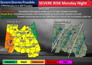
MONDAY’S SEVERE WEATHER RISK: There have been two new trends since I wrote yesterday’s blog. 1) Models have continued to trend later on the timeline for severe weather. The main window now is from 4PM in the far west to 6AM in the far southeast. 2) The Risk area has been updated to a level 2 (Slight Risk) across the entire area. A more ominous Enhanced Risk covers the far western counties, especially along and west of a Tuscaloosa/Demopolis line. That’s where the tornado risk will be highest.
The greatest severe weather risk will be damaging wind gusts as a strong line of thunderstorms moves through the night. Some storms will become severe with damaging wind gusts to 60+ mph. Quarter size hail is also possible. Some of the storms within the line could even spin up a few tornadoes.
I do not currently expect individual super cell thunderstorms ahead of the main line, but that is not completely out of the question. That particular mode of severe weather is more conducive for tornadoes. We’ll monitor new model data which arrives during the day. Stay weather aware. Have a plan of action. Make sure you have our weather app downloaded for your phone or tablet. Go to the App store and search Rich Thomas Weather.
Here’s the Severe Weather Risk Map from NWS in Birmingham. Their responsibility area only covers part of our local counties, however, they have a very helpful timeline of this graphic. You can see this will b e, unfortunately, an overnight event for many of us.

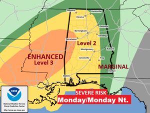
This graphic from the Storm Prediction Center shows the entire state. Notice how the Risk level goes from Level 3 Enhanced in the far west counties to Level 1 Marginal closer to the Georgia border.

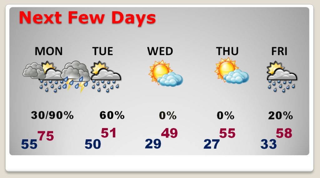
NEXT FEW DAYS: Monday will be the warmest day with mid 70’s. Of course, all eyes on Monday night, with the severe weather threat. Cold Front moves through early Tuesday morning. Falling temperatures Tuesday, and becoming windy. We could be in the upper 20’s, perhaps by Wednesday and Thursday morning. Wednesday’s high may not make it out of the 40’s The next storm system will begin to effect the area by Friday.

—
I’ll continue to monitor the Monday Severe weather Risk as new model data arrives during the day.
I will have a video update for you first thing tomorrow morning at 4:45AM. Have a nice Sunday!
–Rich
