
Good Morning…on the first day of Daylight Saving Time. It’s a chilly start, but like last Sunday, we should see a big warm-up and an absolutely beautiful day. Enjoy it…because there’s more rain in the week ahead.
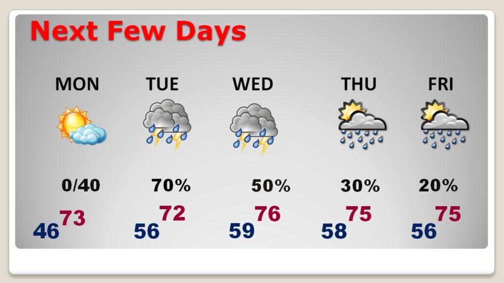
Showers could move in Monday night. Rain and a few thunderstorms are most likely Tuesday and Wednesday. Scattered showers are also possible late week. High temperatures will warm into the 70’s.
TODAY & TONIGHT: There may be a few high clouds around, but sunshine will dominate. Highs will be in the upper 60’s, and maybe teasing 70. Southeast winds at 5 to 10. Sunset on the new time will be at 6:48PM. Tonight’s low 46.
NEXT FEW DAYS: Much of Monday will be dry and warmer. Showers move in Monday night. Showers and thunderstorms are likely Tuesday and Wednesday. Risk for more scattered showers on Thursday and Friday.
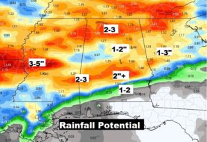
RAINFALL POTENTIAL – SEVERE WEATHER?: Some parts of the state will see 2”+ in the week ahead. A few spots could see 3”. Southeast Alabama will have much lighter amounts.
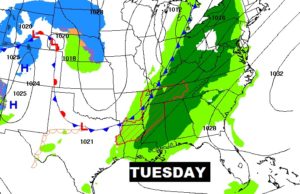
There could be a couple of stronger storms on Tuesday, but the Wednesday situation needs to be watched for the potential for severe weather. We’ll know more as we get closer to Wednesday.
- –
Hope you remembered to Spring Forward overnight. It will be nice to have that extra hour of daylight this evening. I will have a complete video update for you first thing tomorrow morning. It should be online by about 4:45AM. Enjoy this nice day!
–Rich