
4:00PM UPDATE:
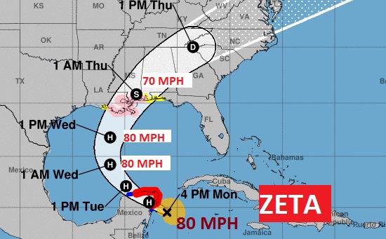
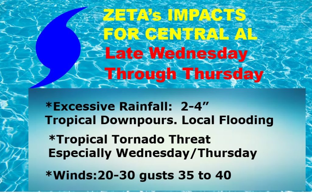
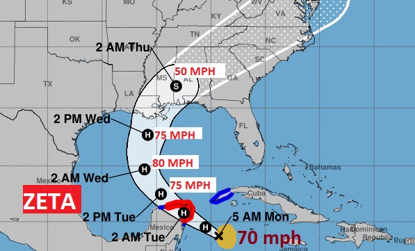
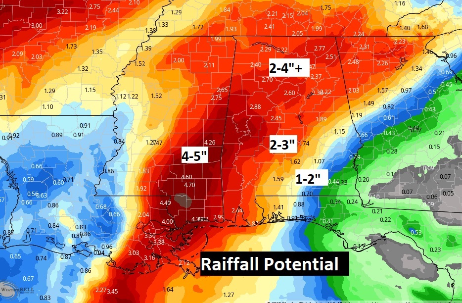
Zeta became the 11th Hurricane of the season, officially at 2PM. Winds are now 80 mph, as the storm approaches the Yucatan. A hurricane watch is now in effect Morgan City, LA to Navarre, FL., including the Alabama coast. Tropical Storm Watch east to the Walton county line. It will remain as a category 1 hurricane in the Gulf as it heads for landfall along the north central Gulf Coast on Wednesday night. It’s likely to be a hurricane at landfall. Impacts here in central Alabama will be most pronounced late Wednesday, and especially Wednesday night, Thursday morning, and into Thursday afternoon. Some of the strongest wind gusts will be Thursday morning, 20-30 mph gusts 35-40 mph. Rainfall: 2 to 4”. Threat of tropical tornadoes, too.
2:00PM UPDATE:
BREAKING NEWS: Air Force Reserve Hurricane Hunter aircraft indicate that Zeta has become a hurricane, with winds near 80 mph with higher gusts. Next NHC Update at 4:00PM #alwx
1:00PM NHC UPDATE:
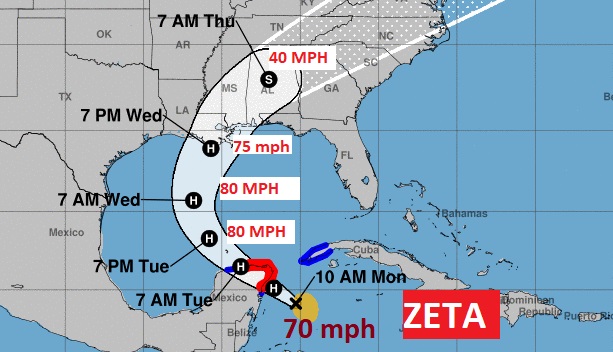
Zeta is still a tropical storm. Maximum winds are now 70 mph, moving NW at 10 mph, toward the Yucatan. Zeta is expected to maintain Category 1 hurricane status is the Gulf until landfall on north central Gulf Coast Wednesday.
Since the track of Zeta is expected to move right through the heart of central Alabama late Wednesday night and early Thursday, I have beefed up the expected impacts a bit. 2-4″ of rain appear likely. Winds 20-30 mph gusting 35-40. Threat of brief Tropical Tornadoes. The forecast will be refined as we get closer.
10:00AM UPDATE; .Not quite a Hurricane Yet. ZETA winds 70 mph, heading toward the Yucatan, expected to become a Hurricane today, then aim for the northern Gulf Coast with landfall Wednesday. Zeta could be close to hurricane intensity at landfall. Alabama will be on the active east side of Zeta. #alwx
EARLY MORNING UPDATE:
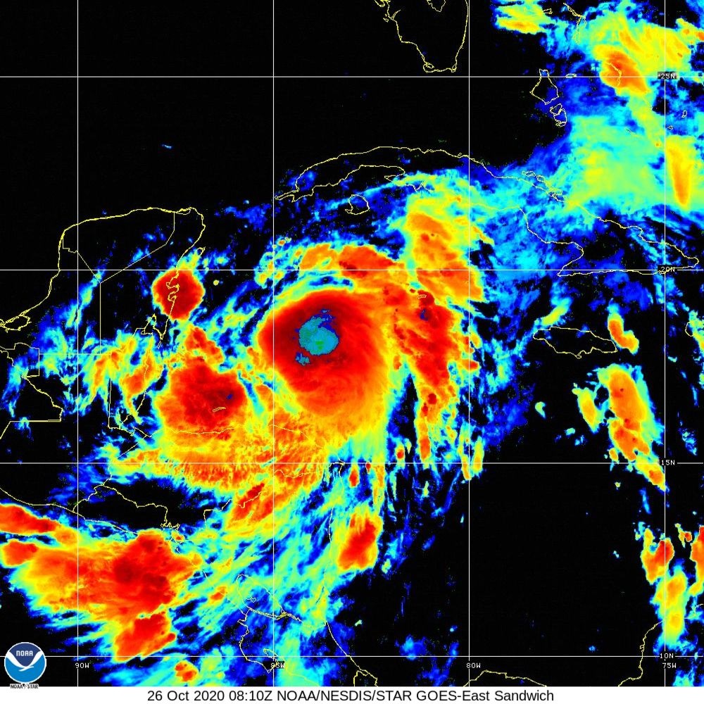
Good morning! Our week is starting off quiet, but all eyes are on ZETA, now undergoing rapid intensification over the NW Caribbean, expected to become a hurricane later this morning, as it takes aim on the US Gulf coast by Wednesday. I have the updated expected impacts for us.
After Zeta, look for big improvements by Friday and Halloween Saturday. Cooler/drier air.
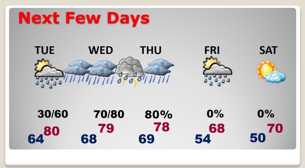
TODAY: Patchy AM fog this morning. Another Mostly Cloudy, dry day. Comfortable. High near 80. Mostly cloudy tonight. Low 64.
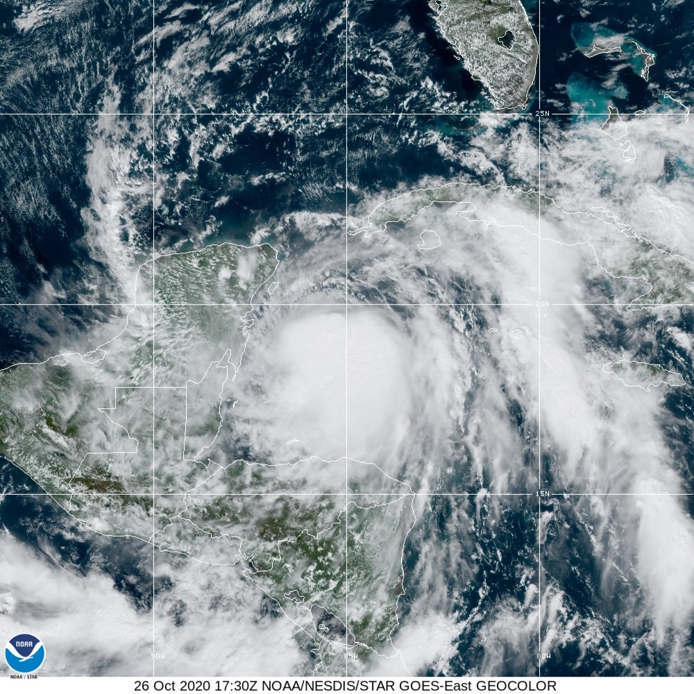
TROPICAL STORM ZETA: Zeta is in a rapid intensification cycle. Winds have increased to 70 mph, moving NW at 9 toward the Yucatan. Expected to become a hurricane later this morning before entering the Gulf. Watches and warning are likely later today for the northern Gulf coast. Zeta is located 210 mile SE of Cozumel.
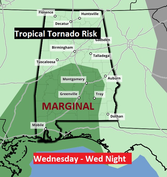
ZETA IMPACTS: For us, Zeta will produce locally heavy rain, gusty winds and the threat of tropical tornadoes, especially late Wednesday and Wednesday night. Zeta will be moving rather quickly when it zips through Alabama. Therefore, no flooding rainfall is expected.
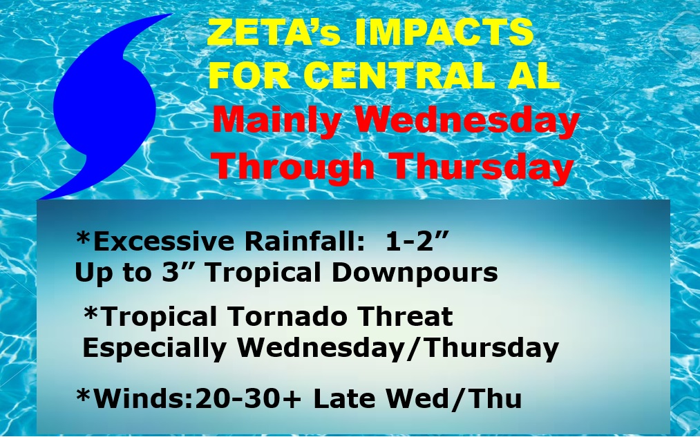
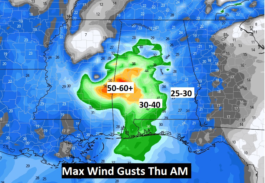
Parts of west central Alabama could see 50-60+ mph wind gusts and 4-6” of rain along the path of Zeta.
Tropical tornadoes are always a threat. Especially late Wednesday and Wednesday night.
NEXT FEW DAYS: After the winds and rain from Zeta, look for big improvements by Friday and Halloween Saturday. Cooler/drier air. A nice change.
—
I’ll have another Blog update in the morning, or probably sooner if needed. Stay safe and well. Have a nice Monday.
–Rich