Good Morning! Welcome to Spring. (Spring began at 4:37AM CDT…The Vernal Equinox) Our first weekend of Spring will be storm-free but quite cool, compared to average. Clouds will gradually give way to sun by some point this afternoon.
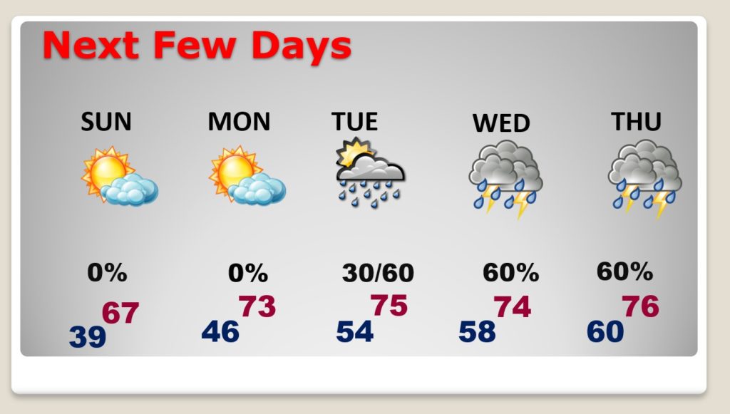
Our storm-free weather continues through at least Monday. Showers and thunderstorms return by Tuesday evening. Looks like a mid-week storm system will bring a lot of rain to central and south Alabama and maybe another round of severe weather. ‘Tis the season.
TODAY: Cool & breezy today. Clouds will dominate the morning. Gradually, clouds will give way to sun later today. High today lower 60’s. East wind at 10 to 16 will gust as high as 20-25 mph. Clear and cold tonight. Low 39.
SUNDAY: Mostly sunny, breezy. High 67. Northeast wind around 10 mph, with gusts as high as 20 mph. Low Sunday night in the mid 40’s.
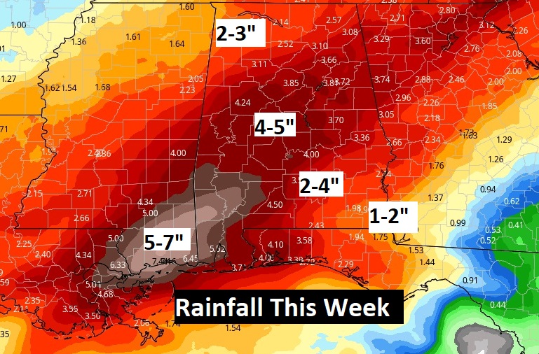
MID WEEK STORM SYSTEM: Don’t look now, but it looks like we’ll be dealing with another significant storm system by mid-week. Looks like it may come in two phases. The final phase by Wednesday night into Thursday could possibly involve more severe weather, depending on how the low evolves, and how far north the warm air sector can advance. Stay tuned. Rainfall totals with this system could be excessive in spots along the track of the low. Here’s one possible solution:

NEXT FEW DAYS: Below normal weekend temperatures will evolve into a warmer Monday. (Normal high 71, normal low 46) We’ll be back to the low 70’s Monday and mid 70’s Tuesday. Risk of showers Tuesday, but better rain chances return by Tuesday night, Wednesday and Thursday. Showers and thunderstorms. Will this system be SEVERE? See below. Rainfall could be excessive.

TORNADO SURVEYS FROM MARCH 17th CONTINUE: National Weather Service survey teams from Birmingham and Mobile have already surveyed ten tornadoes from last Wednesday including 3 strong EF-2s. One of the more significant tornadoes was the Pools Crossroads EF-2 tornado (Autauga county), which affected Billingsley. Here’s a link to all the NWS Birmingham surveyed tornadoes.
https://mesonet.agron.iastate.edu/wx/afos/p.php?pil=PNSBMX&e=202103200301
Here’s the link to all the NWS Mobile surveyed tornadoes:
https://www.weather.gov/mob/2021_March17_Tornadoes
Surveys from both offices are ongoing.
HURRICANE SEASON NEWS: Laura and Dorian were such destructive hurricanes over the past two hurricane seasons that they will no longer be used to name future Atlantic tropical storms or hurricanes. The names Eta and Iota will also be retired.
The decision to retire 2020’s Hurricane Laura and 2019’s Hurricane Dorian was made during an annual meeting held online this week by the World Meteorological Organization’s (WMO) hurricane committee. The Greek alphabet has also been retired for naming storms as part of the announcement. An alternative name list will be used whenever we run out of names on the main list.
Atlantic tropical cyclone lists repeat every six years unless a storm is so severe that the WMO hurricane committee votes to retire that name from future lists.
We are only 73 days from hurricane season.
—
There will be another blog update in the morning. Have a nice weekend!
–Rich
