
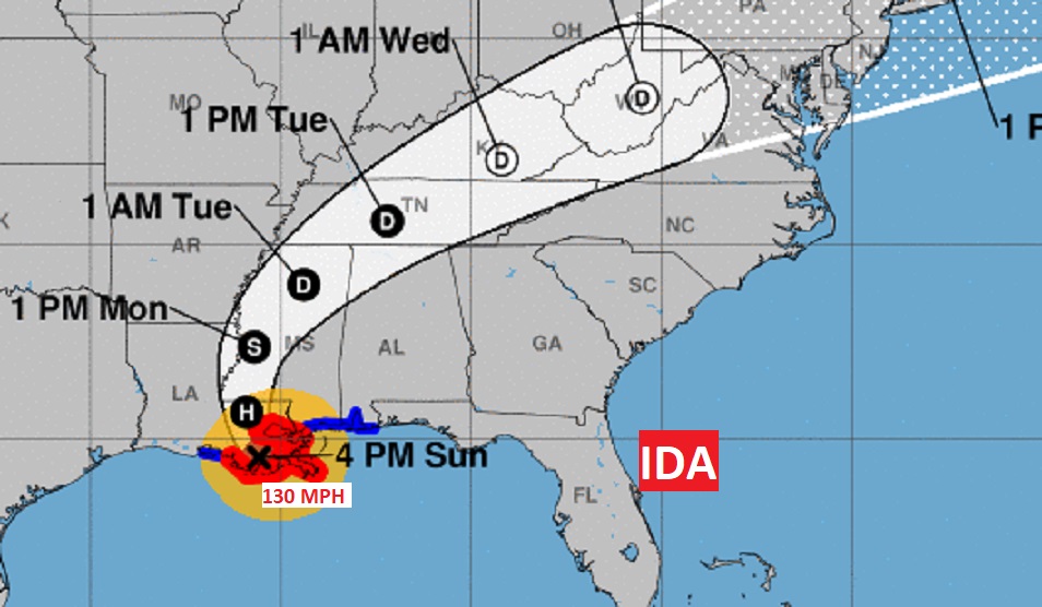
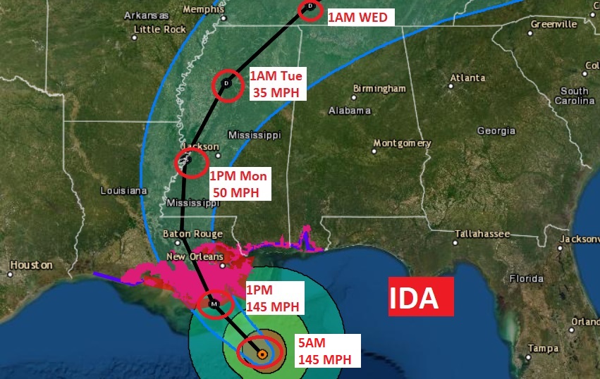
4pm NHC IDA Update
Category 4 hurricane Ida came ashore near Port Fourchon, LA at 11:55 AM with 150 mph winds.. Ida is still an extremely dangerous Cat 3 hurricane with 130 mph winds, located 75 miles Southwest of New Orleans. Slowing down a bit. Moving NW at 10 mph. A hurricane Warning Continues along the the Louisiana coast to the mouth of the Pearl River, including New Orleans. Tropical Storm Warning from the Pearl River as far east as the AL/FL line.
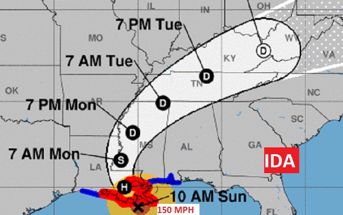
10AM CDT NHC IDA UPDATE –
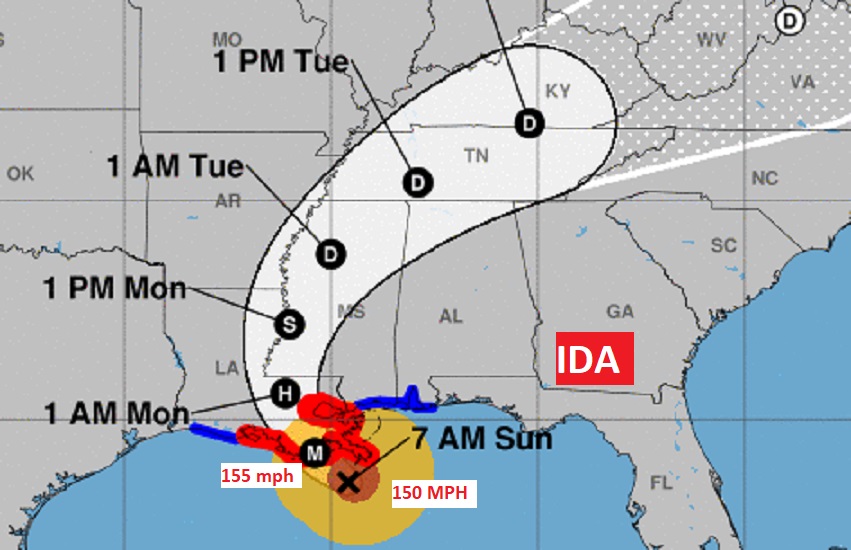
…IDA, close to landfall. Northern Eyewall practically touching the coast. Ida is an extremely dangerous high end Cat 4 Hurricane with 150 mph winds. (Category 5 status begins at 157 mph) Now located 60 miles WSW of the Mouth of the Mississippi. Moving NW at 13 mph. Landfall soon in the Hurricane Warning area, a little west of Grand Isle. A hurricane Warning covers the Louisiana coast to the mouth of the Pearl River, including New Orleans. Tropical Storm Warning from the Pearl River as far east as the AL/FL line. FOR EFFECTS HERE IN ALABAMA SCROLL DOWN.
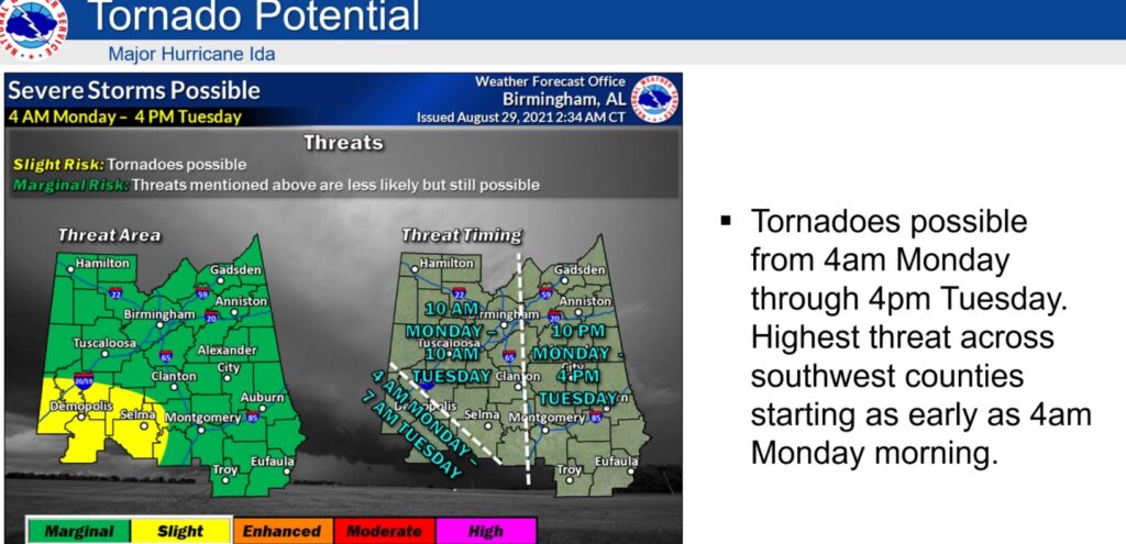
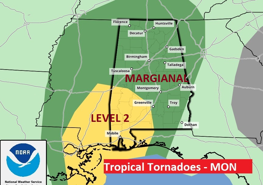
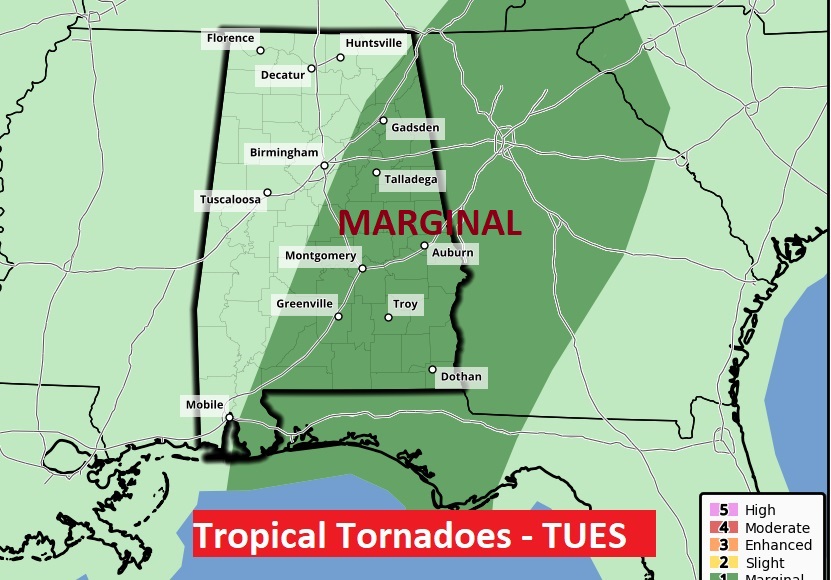
The Tornado Threat is complicated, as far as timing…some of us will have a tornado threat starting Monday morning through Tuesday afternoon. But, it will begin early in SW Alabama, perhaps pre-dawn. In far East Alabama, the biggest threat will be daytime Tuesday. This graphic helps to explain the timing.
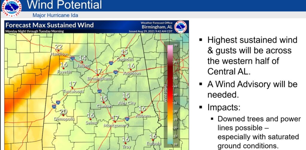
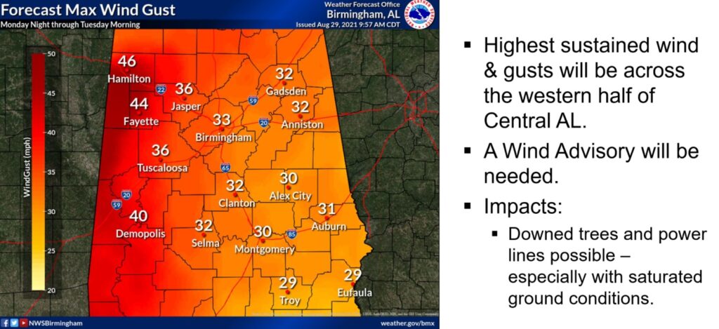
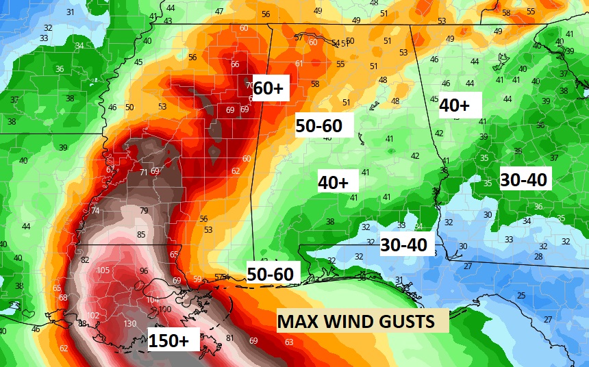
NWS Birmingham has some relatively conservative future wind estimates. Here’s the expected sustained winds and Max wind gusts map. Again, I have seen some models with higher wind gusts estimates.
BREAKING NEWS: 7AM CDT NHC IDA UPDATE –
…IDA, hours from landfall, is an extremely dangerous high end Cat 4 Hurricane with 150 mph winds. Additional strengthening is likely before landfall this afternoon along the Louisiana coast. Could be very close to Cat 5 status at landfall Now located 50 miles south of the Mouth of the Mississippi. Moving NW at 15 mph.. A hurricane Warning covers the Louisiana coast to the mouth of the Pearl River, including New Orleans. Tropical Storm Warning from the Pearl River as far east as the AL/FL line.
EARLY MORNING UPDATE:
Good Morning! Here’s a brief discussion of the current Ida status and the risks for us. IDA is a simply frightening Hurricane. High end Cat 4 now, it could be close to Cat 5 Status at landfall this afternoon in Louisiana. This is going to be a major disaster for the United States, Louisiana, and the greater New Orleans area. It will have far reaching impacts even here in Alabama as you will see on this blog update. I’ll have another Facebook LIVE chat with you at 8:30AM. You can ask me questions in real-time.
HURRICANE IDA:

 IDA Continues to undergo rapid intensification.
IDA is now an extremely dangerous Cat 4 Hurricane with 150 mph winds. Additional strengthening is likely before landfall this afternoon along the Louisiana coast. Central pressure is s shocking 935 mbs. as of 6AM
Now located 75 miles south of the Mouth of the Mississippi. Moving NW at 15 mph.
IDA will be an extremely dangerous major hurricane at landfall on the Louisiana coast today. IDA will quickly weaken and slow down just after landfall.
A hurricane Warning covers the Louisiana coast to the mouth of the Pearl River, including New Orleans. Tropical Storm Warning from the Pearl River as far east as the AL/FL line.
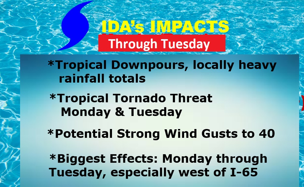
IDA IMPACTS IN ALABAMA: For most of us, the main impacts will be tropical downpours, with locally heavy rainfall amounts, wind gusts up to 40+ mph, and a tropical tornado threat, which could begin in the pre-dawn hours on Monday morning. The greatest tornado risk will likely be Monday afternoon and evening. ALL of us will have a tornado risk, But, the greatest risk of tropical tornadoes Monday will be south of US 80 and West of I-65. The Tropical Tornado risk continues Tuesday, especially in the eastern half of the state, as Ida’s tropical plume, or tail will still be over us. I think there will be dozens of tornado warnings in Alabama from Ida. Lots.
Wind gusts near or just over 40 mph are not out of the question Monday & Monday evening. This is the EURO model. It even shows some near 40+ mph wind gusts in east Alabama, and even west Georgia. The greatest wind swath, however will be west of I-65. Look at west central and NW Alabama. Easily 50 to 60+ wind gusts Monday & Monday night.
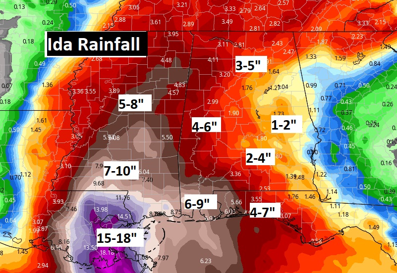
Rainfall will vary greatly across the state, from not much rain near the Georgia border, 2-4 inches in central Alabama, 4 to 6 inches in the western counties. Coastal Alabama will see excessive rainfall totals. 6 to 9 inches on the Alabama coast. But, look at the expected rainfall in southeast Louisiana. Potential disastrous totals.
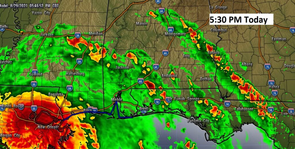
Here’s a summary of the risk. Although the worst weather for us will be Monday & Monday night, Ida’s tropical “plume” will still effect us with tropical downpours on Tuesday. Future radar example shows how numerous tropical rainbands will effect us tomorrow through Tuesday with spin up tornadoes.
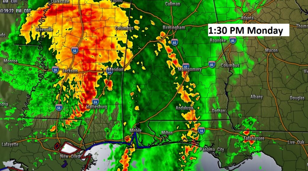
TODAY: Cloudy. High 90. Breezy. East wind 10 to 16+. Scattered showers and thunderstorms by afternoon. Especially late afternoon. Showers and storms more likely tonight. Tropical rainbands with heavy downpours late. Risk of tornadoes by the wee hours. Low 74. Here’s a Future radar example of how Ida’s Tropical Rain bands will start to effect us by this evening.
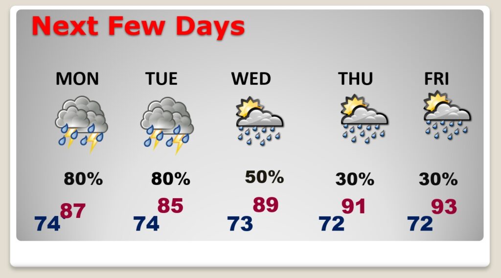
NEXT FEW DAYS: Main IDA Impacts through Tuesday. Things begin to settle down Wednesday. Routine Thursday and Friday. Random scattered pop up storms. Highs in the low 90’s as Labor Day Weekend begins.
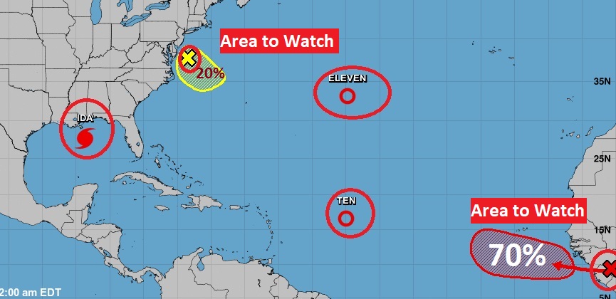
ELSEWHERE IN THE TROPICS: In the Atlantic there is TD 10 and TD 11. Neither are a concern for land. They will stay well out in the Atlantic. There is a new Area to Watch off the middle Atlantic coast. That Area to Watch in Africa is likely to curve, eventually, through the eastern Atlantic and largely be a concern to fish. The next two available names are Julian and Kate.
I will be doing another LIVE Facebook chat with you this morning at about 8:30 AM. (before most folks are in church late morning). Once again, you will be able to type questions LIVE, and I’ll do my best to answer them. There will be updates through the day on the Blog, on the App and on Facebook & twitter.
I’ll have COMPLETE video in the morning on the updated expected impacts from Ida. Stay weather aware.
–Rich