
Good Morning! It’s been an unusually chilly string of days for so late in the season. We’ll be in the upper 30’s again at dawn. But, a southerly wind shift will allow a very nice afternoon recovery today. Most towns will be in the upper 70’s. A few towns will tease 80.
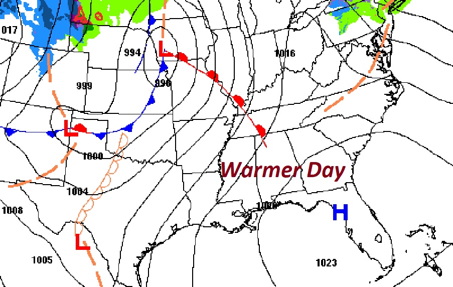
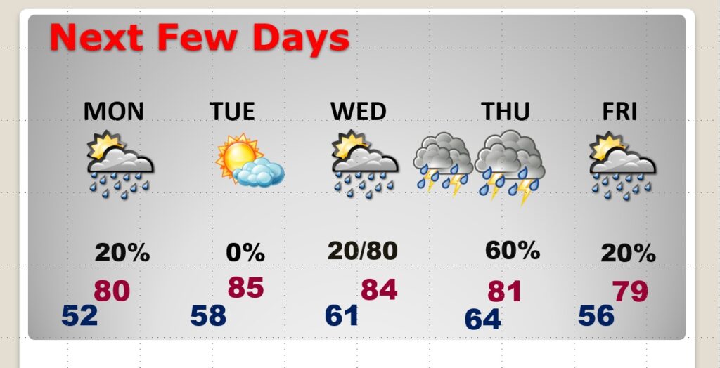
Spotty showers will roam around Monday. Tuesday will be a warmer day with mid 80’s, but mainly dry. We are closely monitoring the next storm system. This system will bring a multi-day severe weather threat to the plains states and middle Mississippi valley Monday, Tuesday & Wednesday. But, the models disagree on how strong this storm system will be when it reaches Alabama. Nevertheless, it is possible that we’ll see some strong to severe storms Wednesday night into early Thursday. This would be the fourth week for a mid-week Severe Threat. We’ll know more as we get closer to this event.
TODAY: Abundant sunshine. Cold start. Warmer afternoon. High 79. South wind 6 to 12 mph. Mainly clear. Not as cold tonight. Low 52.
MONDAY: Breezy & warm. Cloudy at times. Slight chance of showers. High near 80. South wind 10 to 20 mph. Low Monday night 52.
NEXT FEW DAYS: Warmer days. Slight chance of showers Monday. Mid 80’s Tuesday. Showers and locally strong/severe storms Wednesday night into Thursday. More showers Friday,
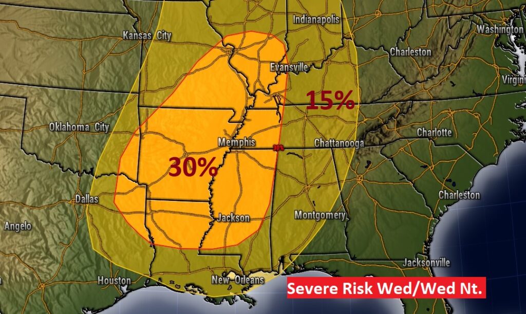
SEVERE WEATHER THREAT: We are closely monitoring the next storm system. This system will bring a multi-day severe weather threat to the plains states and middle Mississippi valley Monday, Tuesday & Wednesday. But, the models disagree on how strong this storm system will be when it reaches Alabama. Nevertheless, it is possible that we’ll see some strong to severe storms Wednesday night into early Thursday. We’ll know more as we get closer to this event. The latest outlook from SPC, through 7AM Thursday, shows a Severe Threat covering much of Alabama through Dawn Thursday.
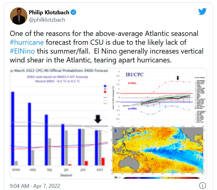
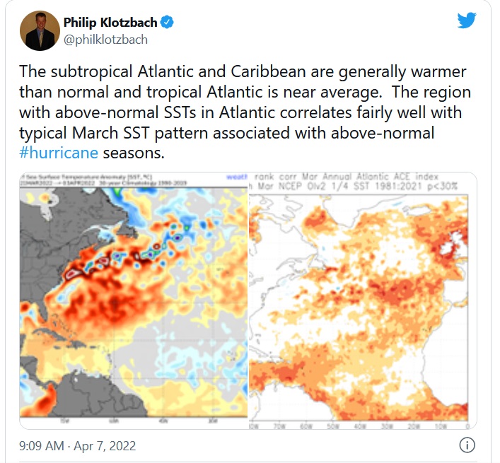
2022 HURRICANE FORECAST:
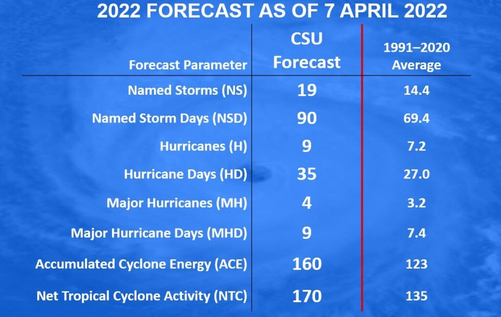
Benchmark hurricane predictor forecasts 19 named storms in 2022: The 2022 hurricane season is spinning up to be a busy one, according to the meteorological team at Colorado State University, which for years has been one of the more reliable predictors of tropical activity.
In its forecast released Thursday, the CSU Department of Atmospheric Science expects an above-average year, predicting 19 named storms this season — five more storms than what the National Oceanic and Atmospheric Administration considers average, based on data collected from 1991 to 2020. Perhaps more eyebrow-raising, however, is its forecast of major hurricane production.
Take a look at the numbers.
Besides the Colorado State Forecast…a Private Company – Weather Bell is also predicting some very disturbing hurricane numbers for the 2022 season:
- Another high-impact season is anticipated for the U.S. coast.
- Long-tracked, large storms are less likely than in-close, smaller storms that form quickly.
- There will again be plenty of “throw-away” storms to the north of the Main Development Region which will pad the total numbers.
- An enigma concerning the Northeast is analyzed.
- The Western Pacific will again have lower than average activity.
First of all, there are no changes to the total numbers, but I will explain the impact numbers in more detail below.
Named Storms: 18-22
Hurricanes: 6-10
Major Hurricanes: 2-4
ACE: 140
.
Have a nice Sunday! I’ll have a complete video in the morning, online by 4:45 AM.
–Rich