
Good Morning! Our Cold Blast continues today. It will be cold Saturday. We may not make it out of the 40’s. And, tonight we’re headed for the 20’s. Look for a major temperature turn-around in the week ahead. In fact, expect 70 or above Tuesday through Thursday. There will be two storm systems in the week ahead. The first storm system will be bring showers to the state by Tuesday. There will be a brief break between storm systems until the second one delivers a round of showers and storms by late Wednesday/Wed. Night and into Thursday. System two needs to be watched for a potential sever weather risk. It’s too early to say. Here’s my brief forecast discussion.
THURSDAY TORNADO TRAGEDY SURVEYS: The National Weather Service continued surveying central Alabama tornado damage yesterday. The Selma Tornado has been determined to be an EF-2 (130 mph), 23 mile track, 800 yards wide, lasting 28 minutes. That tornado may have briefly lifted near the Dallas/Autauga county line. The deadly Kingston tornado in Autauga county was determined to be an EF-3 strength. Details of this tornado are not known yet. Seven died in this tornado. NWS says this tornado could have possibly stayed on the ground though Elmore, Tallapoosa and perhaps into Georgia. Details on this tornado may take awhile to sort out. Five other tornadoes have been surveyed. Details below. Surveys continue today.
Here’s the preliminary updated Storm survey from NWS Birmingham.
https://forecast.weather.gov/product.php?site=NWS&product=pns&issuedby=BMX
MY Good friend Meteorologist Shane Butler used his drone to shoot these dramatic pictures of Selma yesterday. Prolific damage.


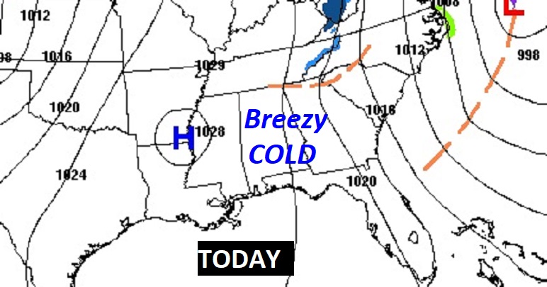
TODAY: Windy and cold. Mostly cloudy this morning, then gradually sunny.. The high temperature may struggle to reach 48. Northwest winds 10 to 20 mph will make it seem much colder. Tonight – Mostly clear, and quite cold. Overnight low 28.
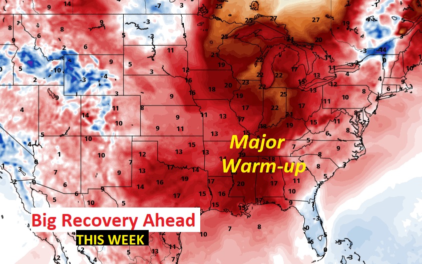
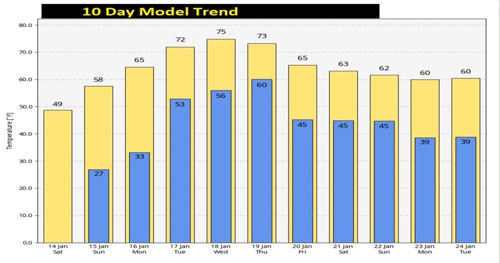
NEXT FEW DAYS: Look for a major temperature turn-around in the week ahead. In fact, expect 70 or above Tuesday through Thursday.
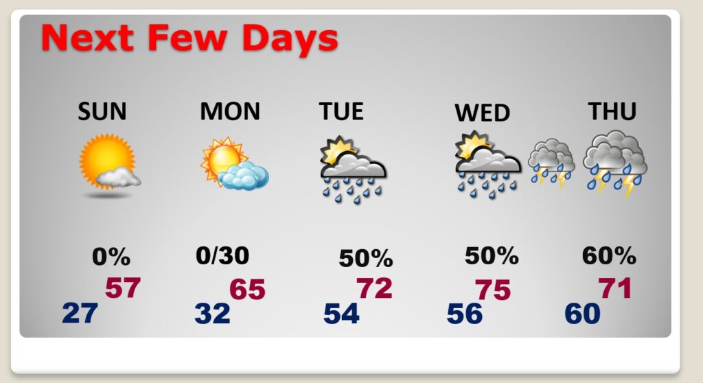
There will be two storm systems in the week ahead. The first storm system will be bring showers to the state by Tuesday. There will be a brief break between storm systems until the second one delivers a round of showers and storms by late Wednesday/Wed. Night and into Thursday. System two needs to be watched for a potential sever weather risk. It’s too early to say. Maybe.
.
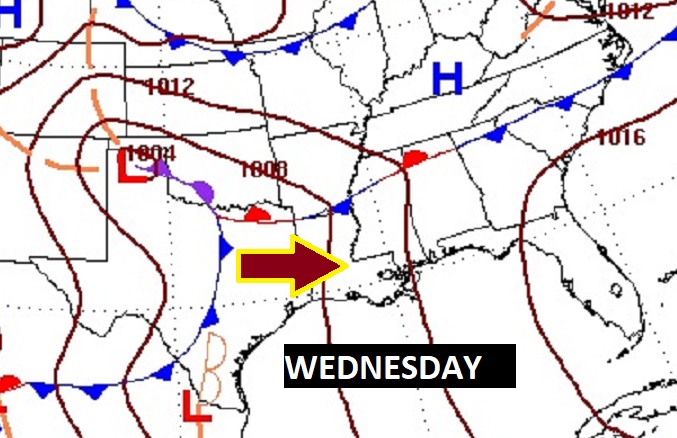
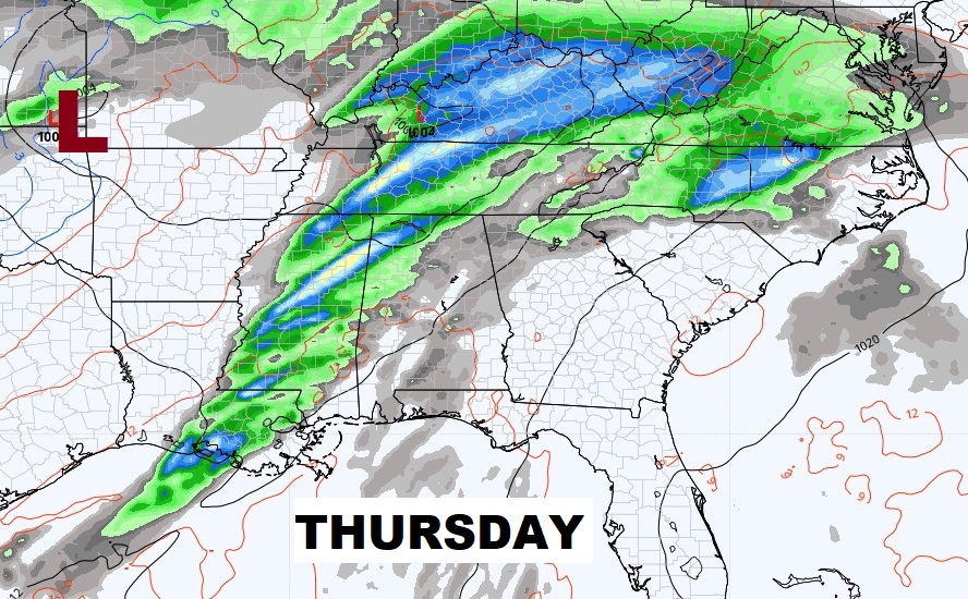
By late Wednesday night into Thursday we’ll be closely monitoring the next big deal storm system.
Another significant storm system is possible during the weekend of January 21/22.
Here’s the 10 day temperature trend. Look at the huge warm-up in the week ahead as the cold retreats.
Thanks for reading this Blog this morning! I’ll have another update for you in the morning. Have a nice day!
–Rich