
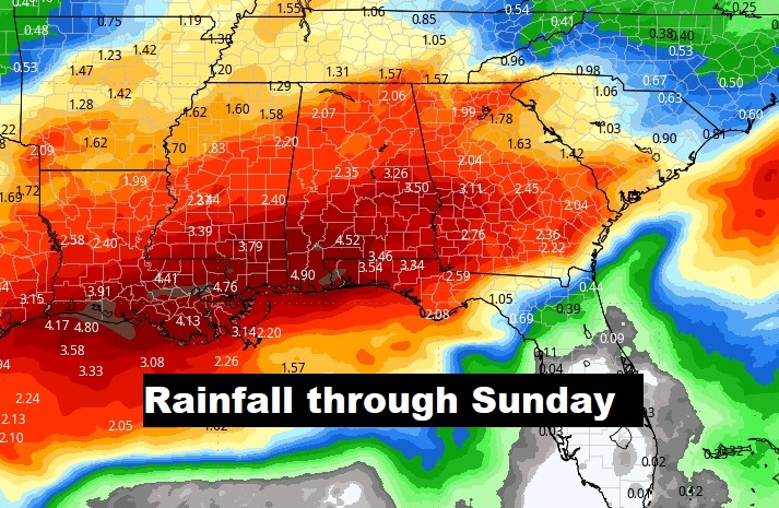
Good Morning! After a rather dismal Sunday, today, Tuesday and Wednesday will be much brighter days. We’ll be well below normal today and Tuesday, and we’ll be near or below freezing on Tuesday and Wednesday morning. Looking ahead, there’s lots of rain in our future late week and beyond. Rain and storms become likely by Thursday night and Friday. Right on the heals of that storm system will be a weekend storm system that will keep us rather wet at times. That’s a weekend that will feature a lot of Christmas tree lightnings and parades. The expected rainfall map below will get your attention. Typical of an El Nino winter. Get used to an active, wet, dismal pattern. Here’s my brief forecast discussion.
.
TODAY: Much cooler. Hi 54. Breezy. NW wind 10-20 mph. Tonight: Cloudy intervals. Cold. Low 33.
It’s a Full Moon morning. It’s the Full Beaver Moon in November. Moonset this morning 6:45 AM. Sunset 4:40 PM. Moonrise tonight 4:48 PM.
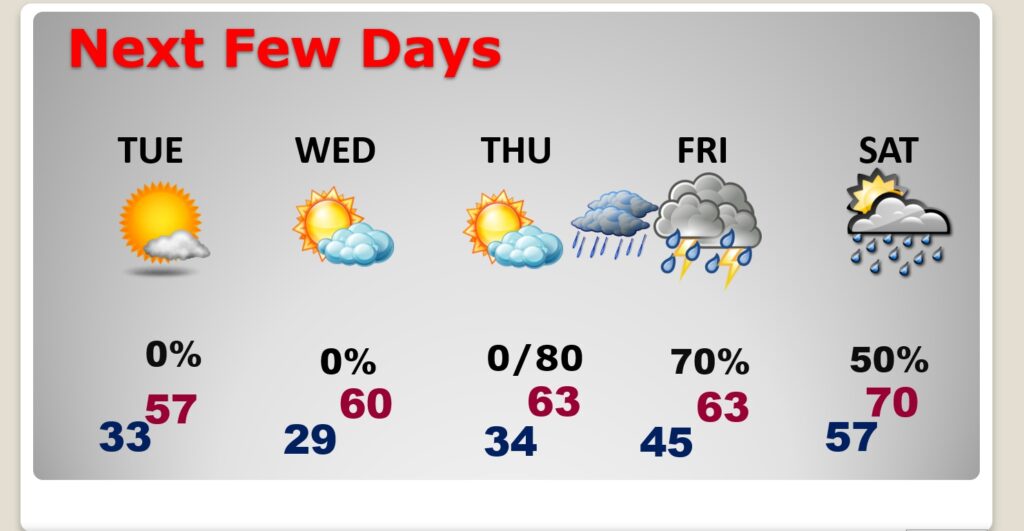
NEXT FEW DAYS: Tuesday and Wednesday will feature a lots of sunshine. Even daytime Thursday, Chilly Tuesday. A little warmer Wednesday and Thursday. Rain and storms become likely by Thursday night and Friday. Right on the heals of that storm system will be a weekend storm system that will keep us rather wet at times. Normal hi/lo 67/41. We’ll not be anywhere close to normal until maybe Friday.
Wet times ahead. Look at the expected rainfall Thursday night through Sunday. This blend of models suggests some of us could see 3 to 4.5 inches.
Here’s the 10 day model temp trend. Coldest days will be today and Tuesday. We’ll be near or below freezing on Tuesday and Wednesday morning. Not as cool late week.

Thanks for reading this Blog this morning! This morning we are LIVE on the radio from 6 to 9 on NewsTalk 93.1. I’ll have another update for you in the morning. Have a nice day!
–Rich