
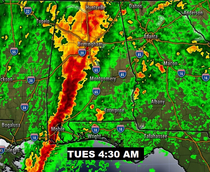
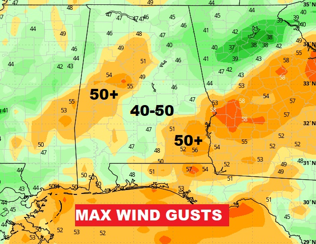
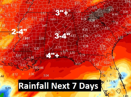
..Just a quick update on Potent Storm System arriving here Monday night with heavy rain, thunderstorms and very gusty wind. This system will bring 3-4” of rain to some spots. But the non-thunderstorm wind gusts will be the main threat. Some places could see 40-50+ mph gusts which will bring down trees. As if that’s not enough, there is a Severe Weather Risk covering much of the southern half of the state. Damaging wind gusts is the main risk. But, over south Alabama, a tornado or two can’t be ruled out. The main line of storms will move through in the wee hours of Tuesday morning. Another big deal storm system arrives Friday. Click on the maps below to enlarge. We’ll get back to a regular extensive blog update and video in the morning.
..SATURDAY MORNING UPDATE:
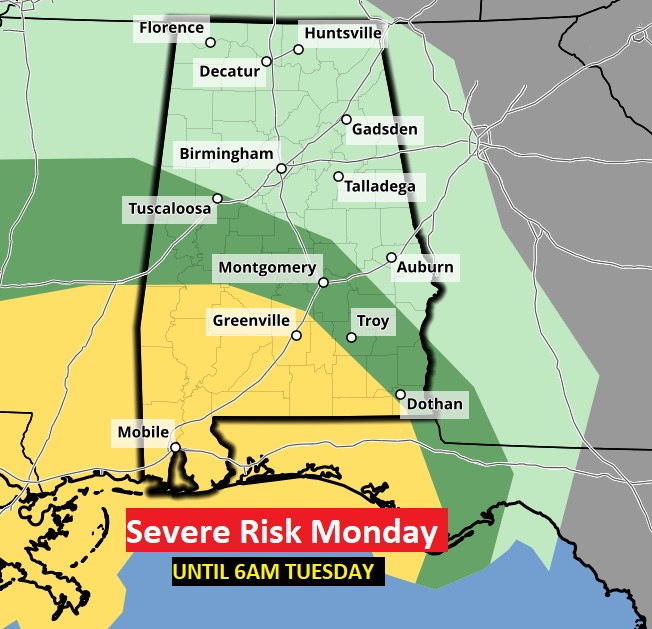
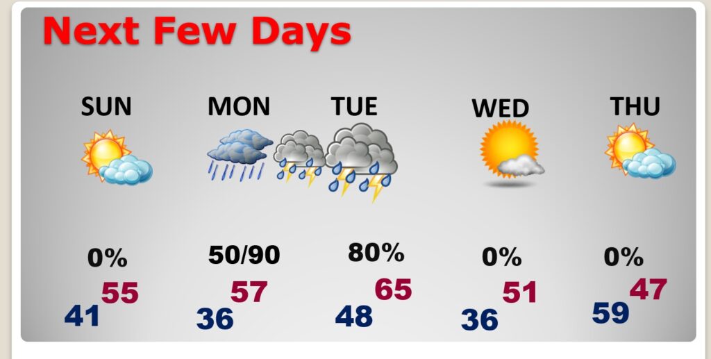
Good Morning! The big storm that drenched the state overnight is departing. It will terrorize the NE states today. We get a nice weekend break between storms system. Today will be breezy, cloudy and dry with falling temperatures by afternoon. Expect a good bit of sunshine Sunday with highs in the 50’s. Then, the next Big Deal storm system approaches as the new week begins. Scattered showers start Monday afternoon. Locally heavy rain and strong thunderstorms move in Monday night into Tuesday. The Severe Weather Risk with this system is increasing for the southern half of the state. See the SPC graphics below. Rainfall amounts could be significant. Details below.
TODAY: Today will be breezy, cloudy and dry with falling temperatures by afternoon. Temperatures will be in the mid and upper 50’s but will fall to near 50 by sunset. West wind at 10 to 20 mph and gusty. Mostly cloudy, breezy and chilly tonight. Low 41.
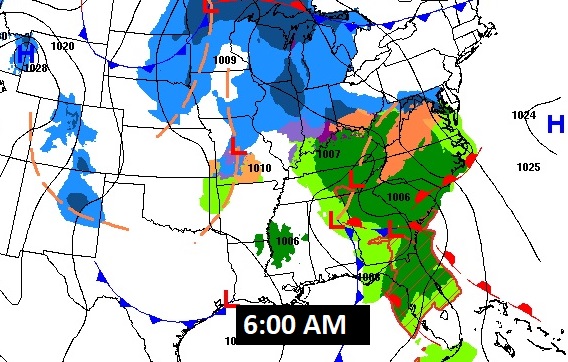
Here’s the map set up at 6:00 AM. This MEGA STORM will paralyze travel for much of the east and NE US. The first big snowstorm in over 700 days for the Northeast.
NEXT FEW DAYS: Our nice break between storm systems continues Sunday. There will be a good but of sun with highs in the mid 50’s. Risk of showers begins Monday afternoon. Widespread locally heavy rain and thunderstorms Monday night in through at least mid-day Tuesday. Back to dry, chilly weather behind the storm on Wednesday and Thursday. Thursday’s high will only be in the 40’s.
The next storm system will be a pretty big deal. Massive in size, and the heaviest rainfall totals, plus a Severe Weather Threat.
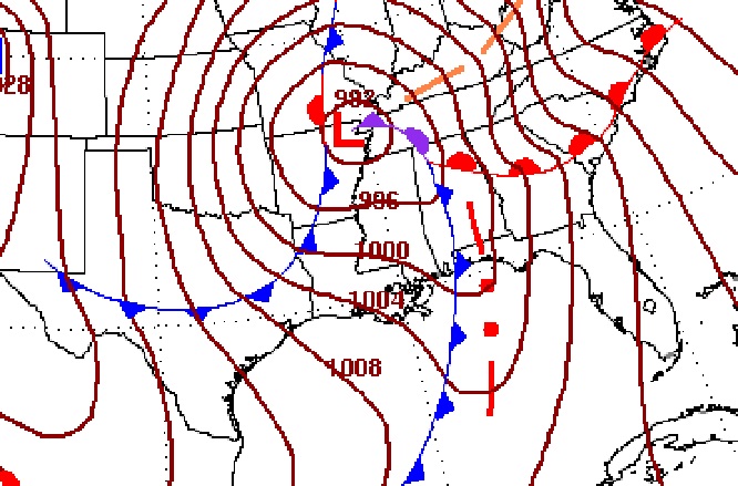
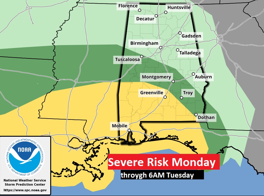
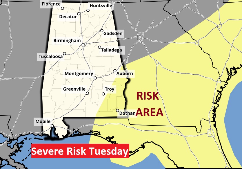
SPC has expanded the Severe Weather Risk which now includes much of south Alabama. In fact most of SW Alabama is now in a Level 2 risk. All modes of severe weather are on the board including tornadoes. The Monday Day 3 outlook continues until 6AM Tuesday morning. On Tuesday, the Severe Risk shifts to SE Alabama and the Southeast US coastline.
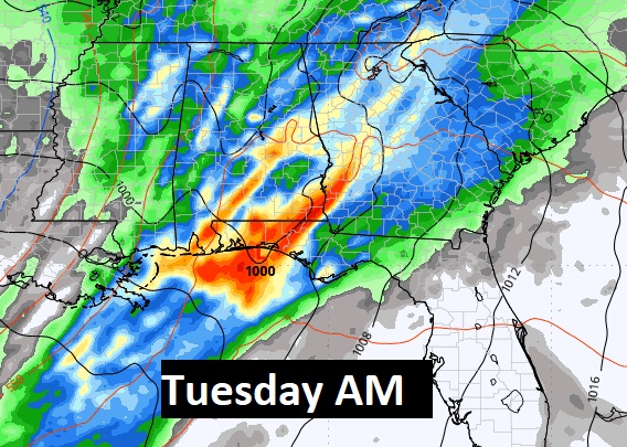
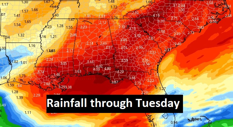
Rainfall amounts could be locally excessive. Heaviest rainfall amounts will be near the Gulf Coast.
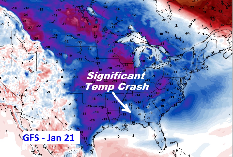
Here’s the 10 Day Model Temperature Trend. COLDER air will begin mid Month. The models may be under estimating how cold we’ll get.
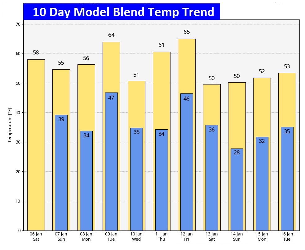
We continue to see more and more clues from the Global models of a potential significant temperature CRASH starting in the next 12-15 days. Here’s the GFS on Jan. 21. The Euro concurs. Any frozen precipitation? Too early to say.
Thanks for reading the blog. The next scheduled blog will be Monday morning. Have a nice weekend!
–Rich