
Good morning! We’re enjoying a nice string of days storm-free, sunny, dry days. Looks like a really nice weekend. Sunshine will dominate each day through Sunday. Today’s high will be near 70. The warming continues on Sunday and Monday with upper 70’s expected. Risk of widely scattered showers arrives on Eclipse Monday, unfortunately. There’s at least some hope that we will see “peaks” of the Eclipse Monday afternoon. More on that below, On the other hand, it will be nearly ideal weather for the Maxwell Air show this weekend. The probability of showers and thunderstorms increases Tuesday and Wednesday.
TODAY: Sunshine. Still below normal. High near 70.. (Normal 76/50) North wind 6 to 12 mph. Clear and cold tonight. Low near 40..

.
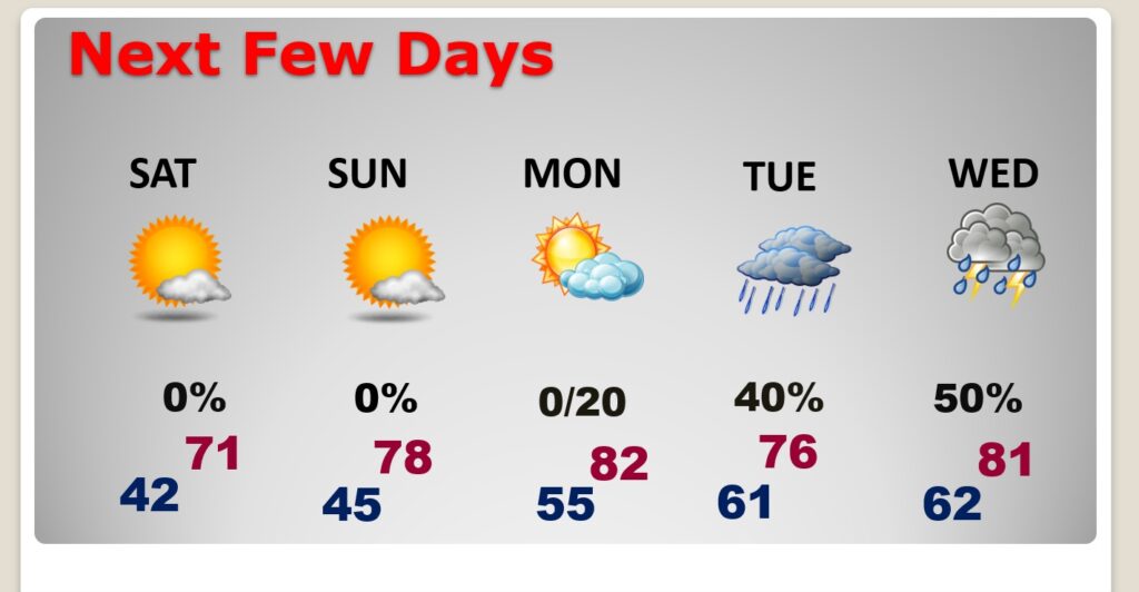
NEXT FEW DAYS: Sunshine will dominate each day through Sunday. By Saturday we’ll be near 71. The warming continues on Sunday and Monday with upper 70’s expected. Risk of widely scattered showers begins on Eclipse Monday. The probability of showers and thunderstorms increases Tuesday and Wednesday.
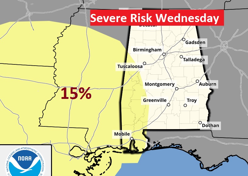
On Wednesday (Day 6), SPC edges the Severe Weather Risk into west Alabama. We’ll see if that coverage area increases as we get closer to the event.
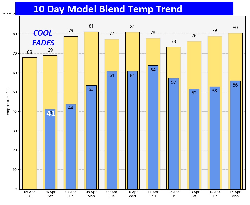
Here’s the 10 day temperature trend. A nice warm-up begins this weekend.
Who will see the #SolarEclipse2024 and who won’t? Due to clouds, looks viewing will be less than ideal especially across parts of the South and mid-section. Better in the Northeast. However, there’s at least SOME HOPE that we will see “peaks” of the 2 hours 37 minute Eclipse, at times, here inn Alabama. I’m a little more optimistic this morning, then I was yesterday.


The Eclipse starts at 12:40 PM and ends at 3:17 PM. Reaching a peak of 86% coverage at 1:59 PM.

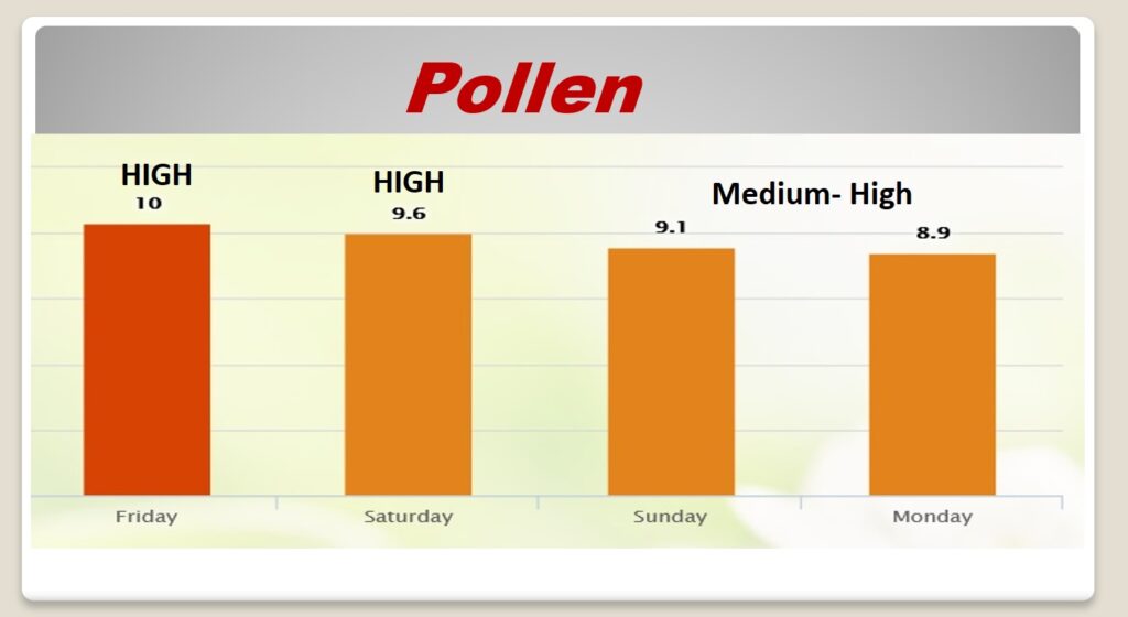
POLLEN: Here’s the forecast for the next 4 days..
BEACH FORECAST: Temperatures will be below normal, otherwise, it’s a really nice Beach Forecast this weekend. Gulf water is still quite cool. HIGH Rip current risk today. Moderate Saturday and Sunday.

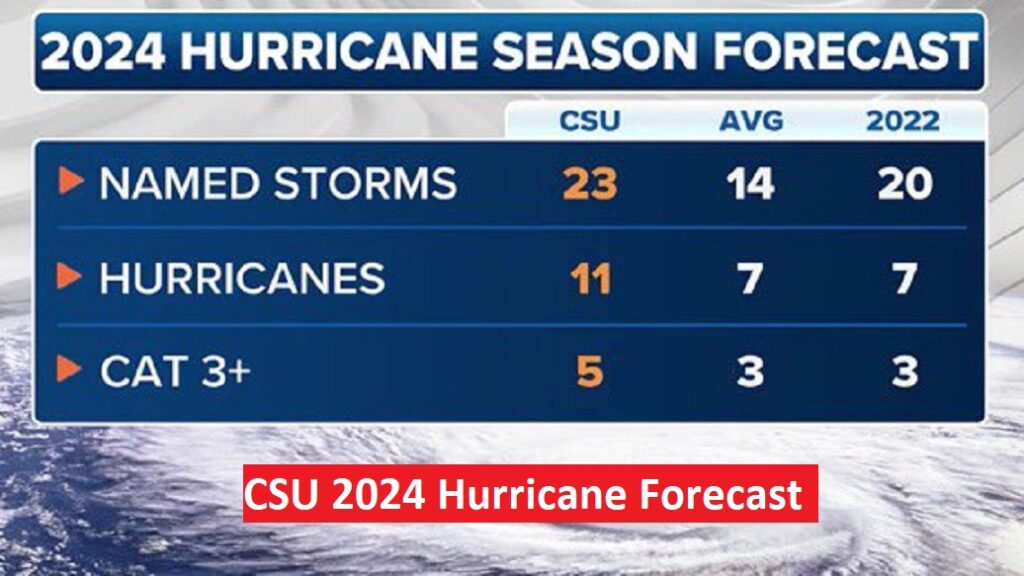
CSU 2024 Hurricane Outlook: Forecasters at Colorado State University issued their most active Hurricane Season forecast in the 41 years of issuing seasonal outlooks. Dr. Phillip Klotzbach from Colorado State University, projecting a MUCH above normal 2024 Hurricane Outlook. 23 named storms, 11 hurricanes and 5 major hurricanes, due to very warm Sea Surface temperatures and a developing La Nina.
Thanks for reading the Blog this morning. As the National Tropical Weather Conference draws to a close, today is a travel day for me. I’ll be back in Montgomery tonight. Look for the Weekend Blog Update tomorrow morning. Have a great weekend!
–Rich