
UPDATE:
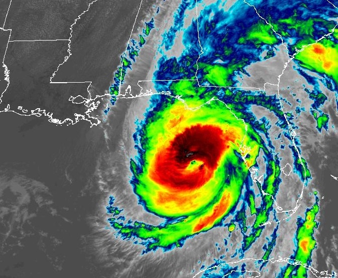
RECON reports Helene has reached Cat 4 – 130 mph status and still 4+ hours until landfall. A large historic hurricane.
3:00 PM:
Post
Reply
See new posts
Conversation

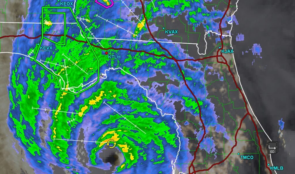
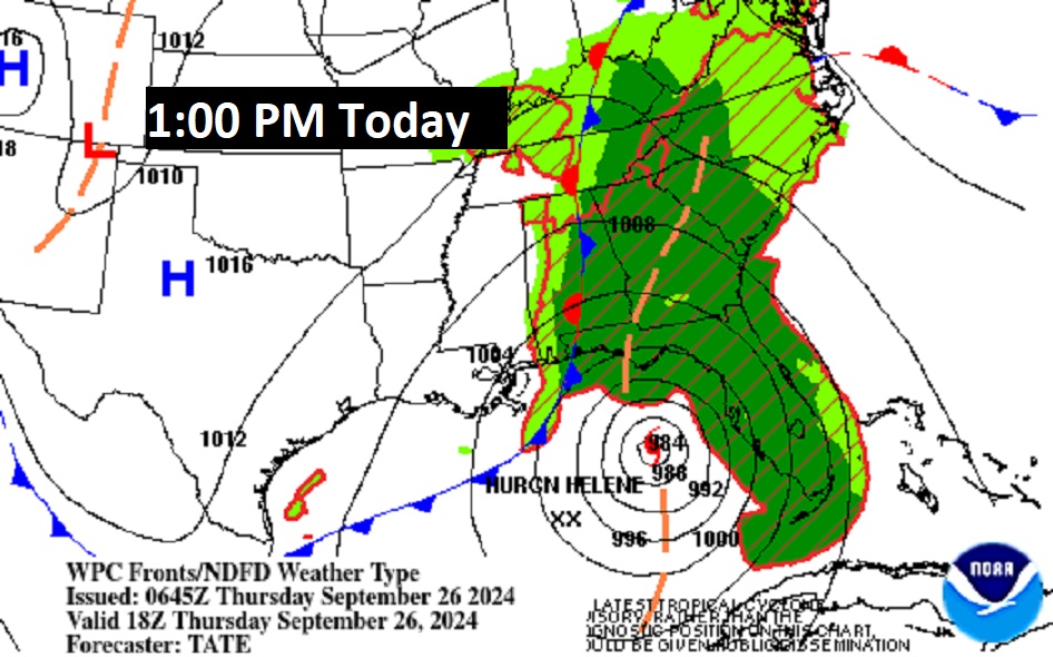
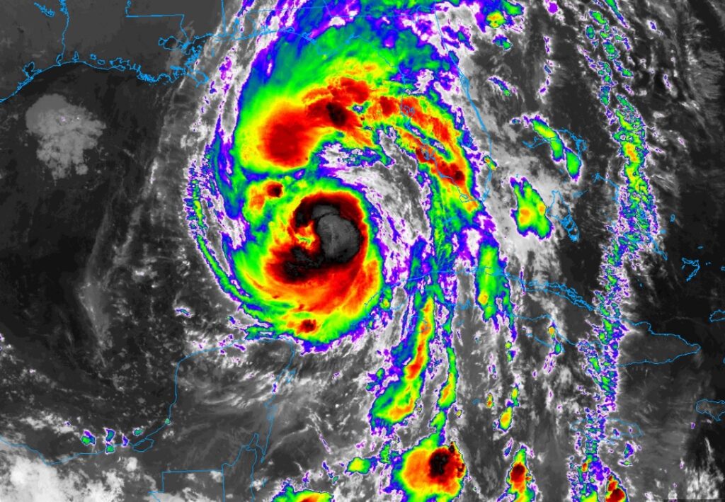
NOW from NHC: …HELENE ACCELERATING TOWARD THE FLORIDA BIG BEND… …TROPICAL STORM CONDITIONS OCCURING ACROSS MOST OF THE WEST COAST OF FLORIDA… Data from an Air Force Hurricane Hunter aircraft indicate that the minimum pressure of Helene has decreased to 951 mb A Weatherflow station at Egmont Channel at the entrance to Tampa Bay recently measured a sustained wind of 54 mph ( and a gust to 68 mph The Sarasota-Bradenton International Airport recently measured a sustained wind of 43 mph and a gust to 63 mph (101 km/h). SUMMARY OF 400 PM EDT…INFORMATION ———————————————- LOCATION…27.3N 84.7W ABOUT 145 MI… WSW OF TAMPA FLORIDA ABOUT 165 MI… S OF APALACHICOLA FLORIDA MAXIMUM SUSTAINED WINDS…120 MPH…195 KM/H PRESENT MOVEMENT…NNE OR 25 DEGREES AT 21 MPH.. MINIMUM CENTRAL PRESSURE…951 MB…28.08 INCHES. Satellite below looking like a classic LARGE hurricane.
2:00 PM:
The Air Force Hurricane Hunters found that the maximum sustained
winds have increased to near 120 mph (195 km/h).  This makes
Helene a dangerous category 3 major hurricane.  Additional
strengthening is expected before Helene makes landfall in the
Florida Big Bend this evening.

SUMMARY OF 225 PM EDT...1825 UTC...INFORMATION
----------------------------------------------
LOCATION...26.7N 84.9W
ABOUT 170 MI...280 KM WSW OF TAMPA FLORIDA
ABOUT 205 MI...335 KM S OF APALACHICOLA FLORIDA
MAXIMUM SUSTAINED WINDS...120 MPH...195 KM/H
PRESENT MOVEMENT...NNE OR 25 DEGREES AT 16 MPH...26 KM/H
MINIMUM CENTRAL PRESSURE...959 MB...28.32 INCHES
10:00 UPDATE:
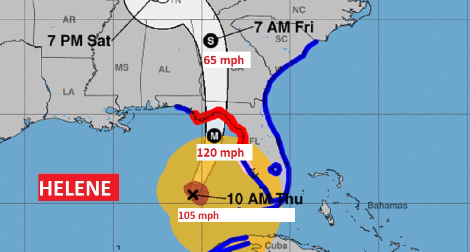
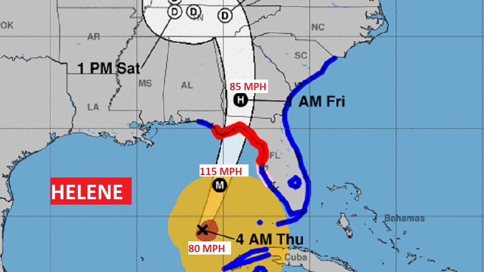
Helene is a little stronger now with winds of 105 mph (Cat 2), moving NNE at 14, pressure now down to 960 mbs. Located about 290 miles south of the Big Bend, with expected landfall late tonight, perhaps closer to 10PM. Expected to reach Cat 3, winds 120 mph around 7PM, while still intensifying before landfall. Storm Surge perhaps as high as a stunning 20 feet near landfall, Helene is an enormously large hurricane with wide range inland effects. Tallahassee will take a particularly hard hit. As will Albany and much of the state of Georgia. #FLwx #alwx
EARLY MORNING UPDATE:
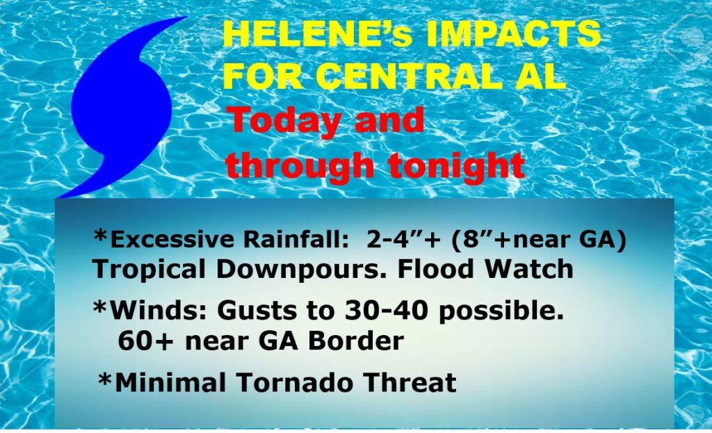
Good morning! The models are still in excellent agreement on the future track and intensity of Hurricane Helene. Helene is intensifying and expected to become a Major Category 3 hurricane (or higher) with landfall expected along the northeast Florida Gulf Coast tonight. For us, Local effects: Flood Watch continues, with 2-4” near I-65 to 6-8”+ near the Georgia border. Wind advisory tonight and Friday. Wind gusts 30-40+ mph as far west as I-65, and 50-60+ mph in far east and SE Alabama. Periods of rain and maybe a couple of thunderstorms. Rainfall will increase through today and especially tonight. Locally heavy rainfall. The tornado threat is minimal Rain will taper off Friday morning. The weekend looks sunny & dry. Here’s my brief forecast discussion.
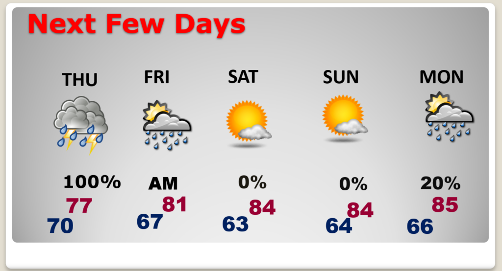
TODAY: Periods of rain, maybe some thunderstorms. Flood Watch continues. High 75. Northeast wind 15-20+ today and gusting as high as 30-40 mph tonight and early Friday. Wind advisory tonight and Friday. Low tonight 69.
ROUGH Friday AM in the ATL Metro.
HELENE UPDATE: Tropical Storm Helene is becoming stronger and better organized. The models are very much in agreement on the timing and the track at landfall. Winds have increased to -90 mph (Cat 2.), Now 625 miles south of the NE Florida coastline, moving NNE at 12. Pressure 966 mbs.
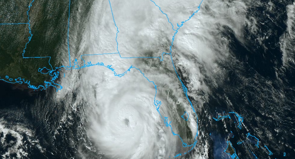
Helene is a very large hurricane.
Helene could reach Cat 3 intensity with 115 mph winds due west of Tampa by mid afternoon, with futher stregthening before landfall tonight between 8PM and Midnight., Catastrophic Storm surge with Helene will be prolific (15-20 feet near Landfall), perhaps to record levels on the part of the coast. NWS is describing the expected storm surge in the Big Bend as “inscribable”
.
Here are some of the model landfall positions. Time line, now slightly later They are amazingly similar. The GFS, Euro ECMWF, and The the NAM
.
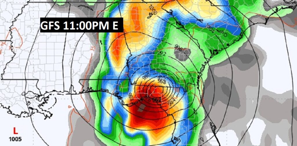
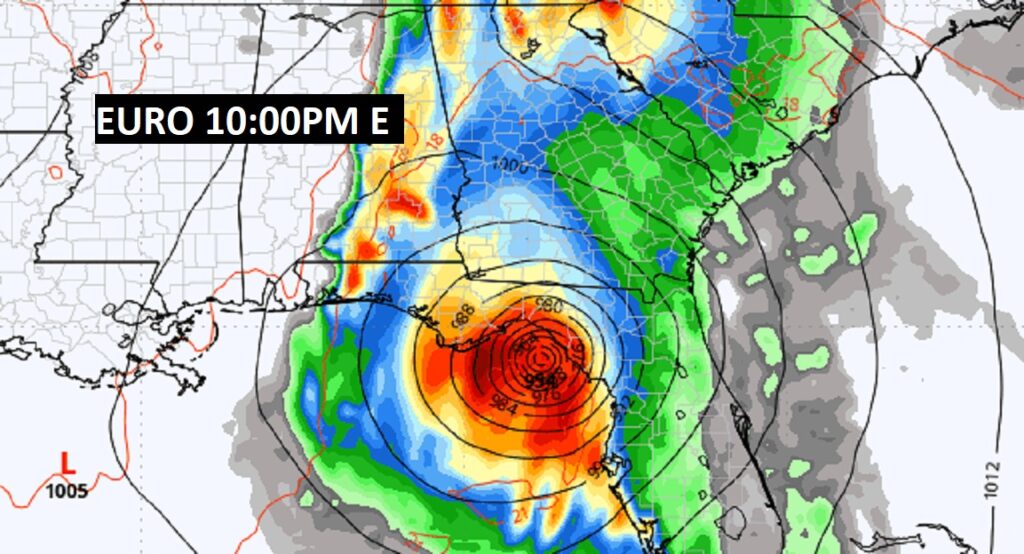
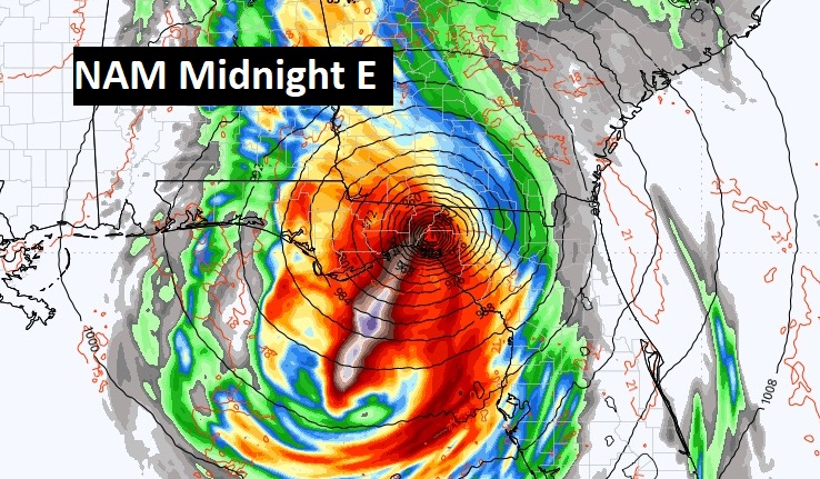
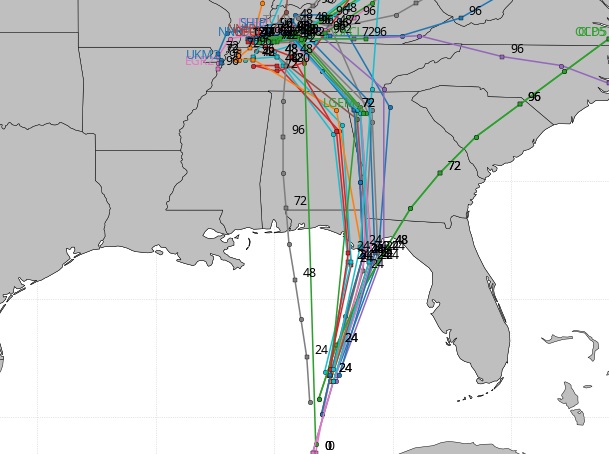
The Spaghetti models. The consensus center line is not too far from the GA/AL border.
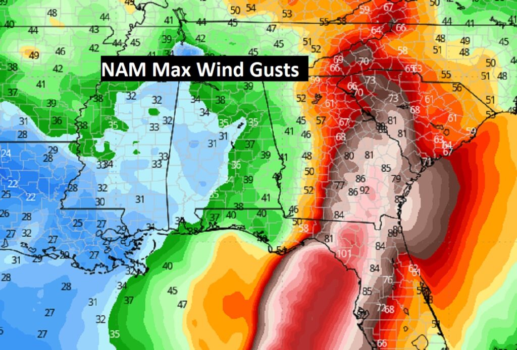
Local effects from Helene are mainly excessive rainfall totals over the eastern half of the state. Flood Watch. And wind gusts to 30-40+ mph from I-65 eastward. Perhaps as high at 60+ mph near the Georgia border.
From the American North America model (NAM) model, here are some projected wind gusts.
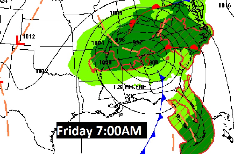
Rainfall along the path of Helene will be prolific, especially in Georgia.
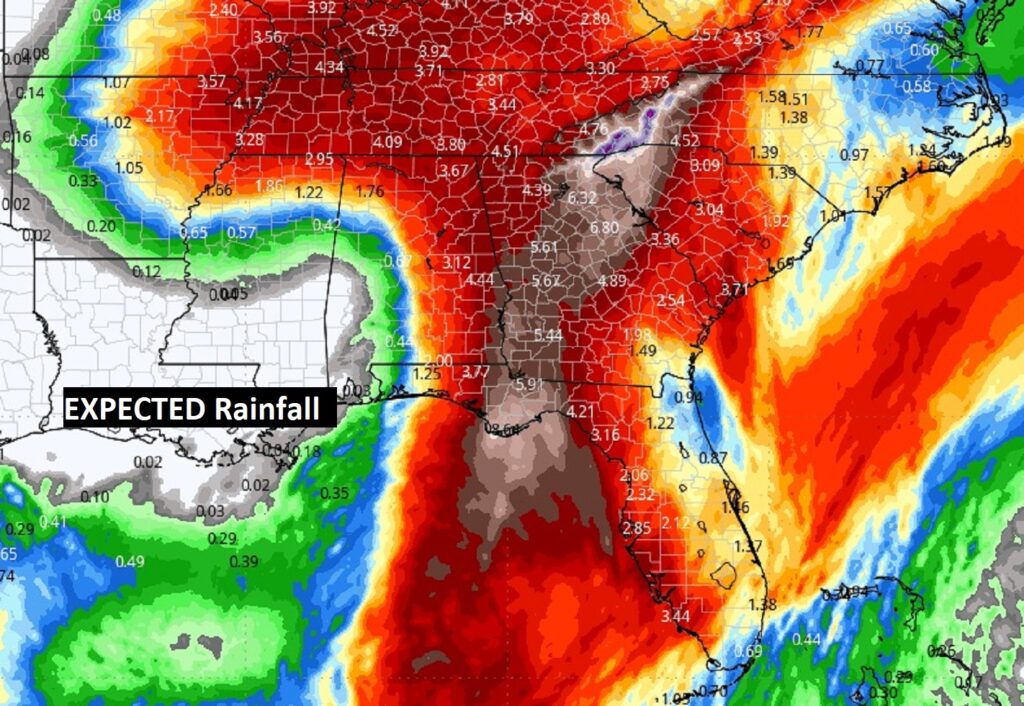
The one below is easier to see the numbers.
NEXT FEW DAYS: Rainfall tapers off Friday morning, and then it should become Mostly sunny in the wake of Helene, The weekend looks sunny and dry Highs in the mid 80’s and 60’s at night. Small chance of showers by Tuesday.
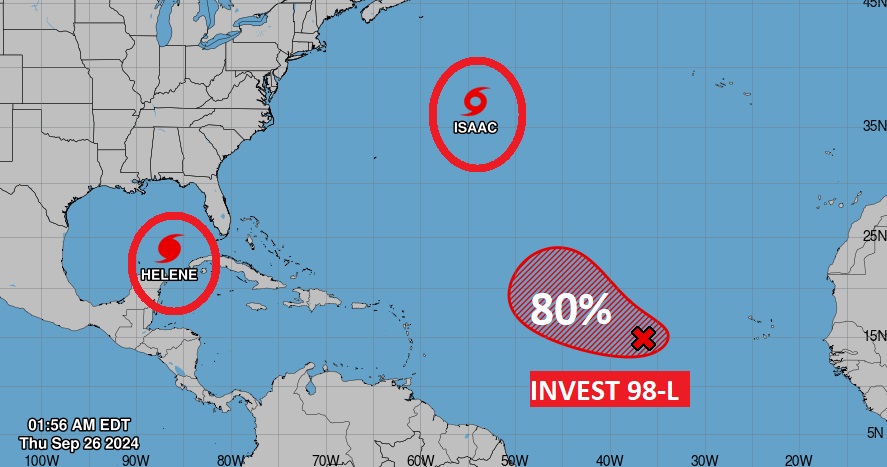
Elsewhere in the Tropics: Tropical Storm Isaac has formed in the central Atlantic. It is what we call a “fish storm.” It won’t effect land. Invest 98-L in the Tropical Atlantic MDR has an 80% chance of development. Next available name is Joyce.
Thanks for reading the Blog . This morning, everything is normal including LIVE on the Radio from 6 to 9AM on NewsTalk 93.1 – WACV. Have a nice day!
–Rich