
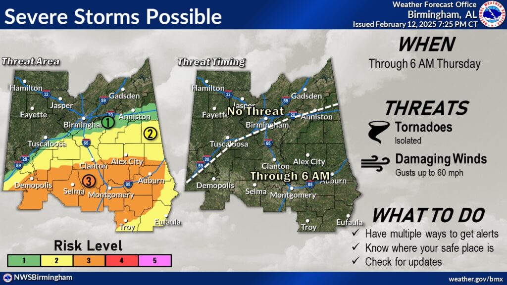
7:30 PM:
UPDATED Threat Level map and timeline. As the reluctant warm front creeps northward the greatest overnight threat will be in that Level 3 Enhanced area from Clanton/Alex City southward, through the overnight hours. Definitely not out of the woods yet. Stay weather aware. #alwx
1:30PM:
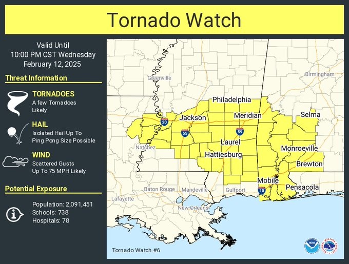
First Alabama tornado watch of the day. It includes Dallas and Wilcox, as far south as Mobile. LONG watch until 10PM. Few tornadoes likely. Hail up to ping pong size and scattered wind gusts to 75 mph. Incredible temperature gradient at the moment. it’s 55 in Montgomery and 81 in Troy. There will be additional watches later. #alwx
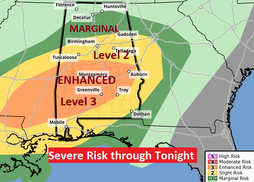
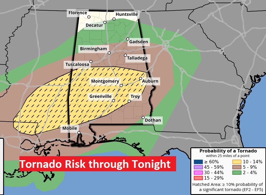
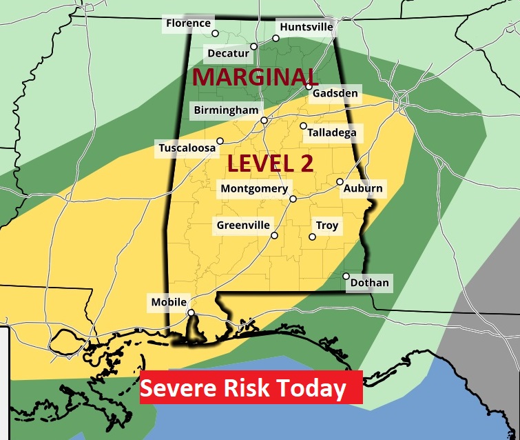
EXPANDED ENHANCED TORNADO RISK
(10:45AM 2/12/2025)
Just what we did NOT want to see. The Storm Prediction Center has now expanded the Enhanced Severe Weather Risk (Level 3 out of 5) area eastward. It now includes most if central and into south Alabama. Not only that. The Tornado Risk has also expanded. Notice the hatched area of the map. This indicates a 10% or greater risk of a strong (EF2 or greater) Tornado, within 25 miles of any given point. The risk will be highest from about late afternoon until and through late tonight and into the overnight hours. Please make sure to allow notifications on our Weather App, and make sure your Weather Radio is plugged up and in the alert mode. Do not depend on Weather Sirens. If you live in a manufactured or mobile home, be ready to go to a more substantial structure when a Tornado Watch is issued.
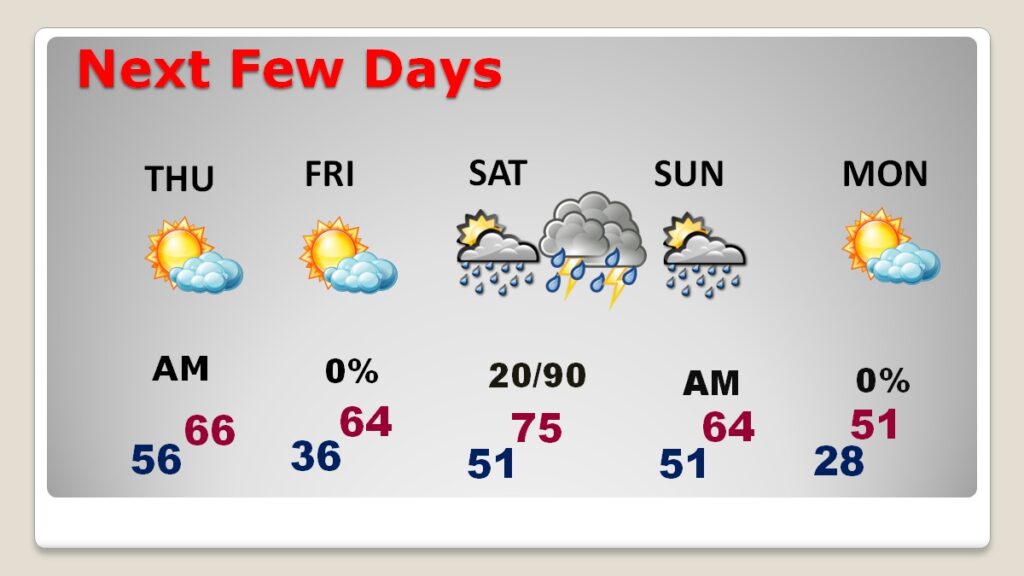
Good morning! The forecast is quite complicated. Everything today depends on how far north the warm front progresses. Right now, it appears the greatest threat for the heavier rainfall amounts and the greatest severe weather threat will be across central Alabama, including a Tornado Risk. The US 80/I-85 corridor will likely be the middle ground for the greatest threat today. Right now, SPC has a Level 2 severe threat, but they have considered increasing the threat to Level 3 – Enhanced. Keep in mind that’s a possibility. Locally heavy rainfall amounts are possible. The rain threat will end Thursday AM. Then, there will be a period of quieter weather for a day or two. We’ll be in the 30’s by Friday AM. Highs in the 60’s. But then, the next storm system moves in by Saturday evening and Saturday night with yet another severe weather threat. Again, there will be a risk of a few tornadoes. Behind this system, it will turn sharply colder Sunday into Monday. We’ll be in the upper 20’s by Monday Dawn. It’s definitely a complicated forecast. Here’s my brief video forecast discussion.
.
TODAY: Periods of showers and thunderstorms today and tonight. Some storms strong possibly severe. Potential damaging winds and tornadoes are possible. Windy. East wind 6 to 16 gusting to 25. Warm. High 79. Low tonight 56.
Today, everything depends on how far the warm front gets. That will be the battleground.
Currently SPC has a Level 2 threat for most of us. They have considered increasing the risk to Level 3 Enhanced. We’ll see what they do on their next 2 updates at 7AM and 11:30AM. Stay tuned. Damaging wind gusts and tornadoes are possible.
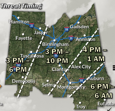
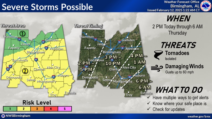
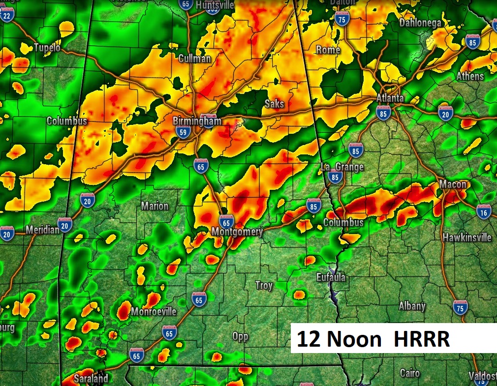
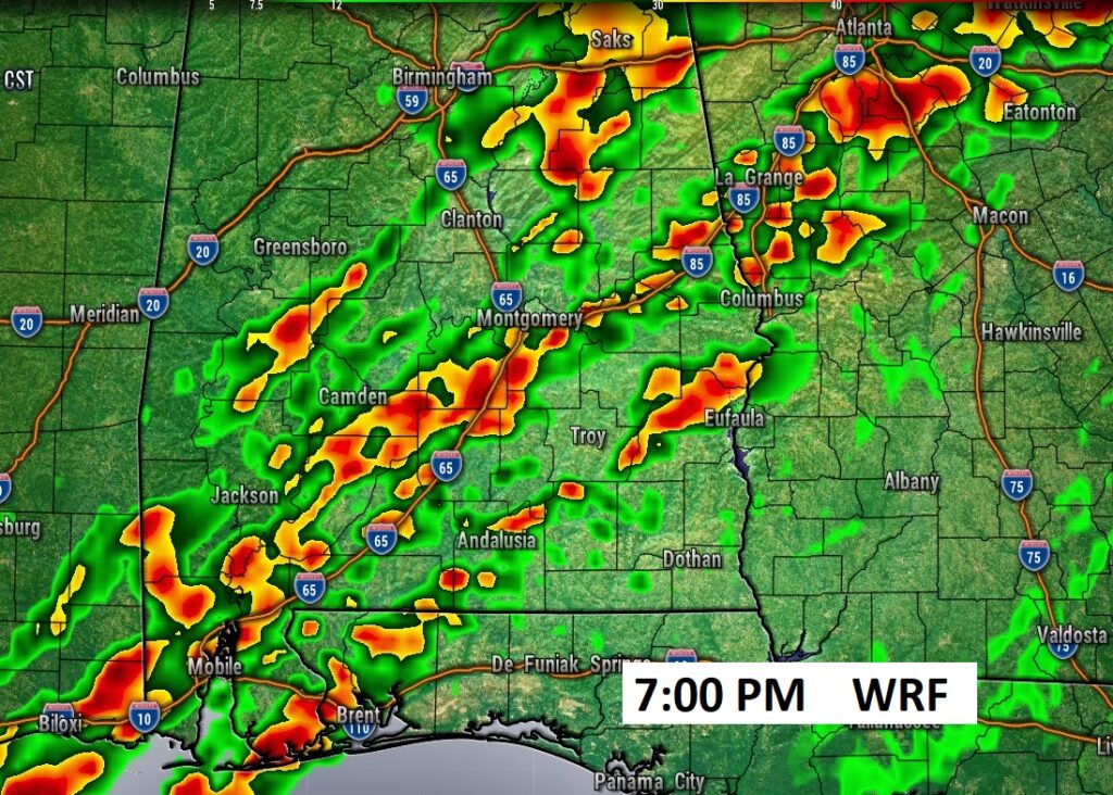
This is a helpful guide on potential Severe Weather timing today and tonight.
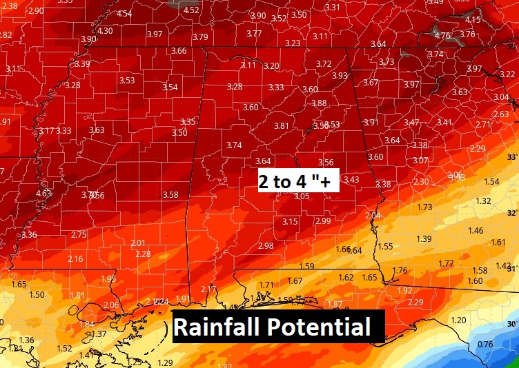
Rainfall amounts could be excessive in spots.
NEXT FEW DAYS: Wet and active. The rain threat will end Thursday AM. Then, there will be a period of quieter weather for a day or two. We’ll be in the 30’s by Friday AM. Highs in the 60’s. But then, the next storm system moves in by Saturday evening and Saturday night with yet another severe weather threat, Behind this system, it will turn sharply colder Sunday into Monday. We’ll be in the upper 20’s by Monday Dawn.
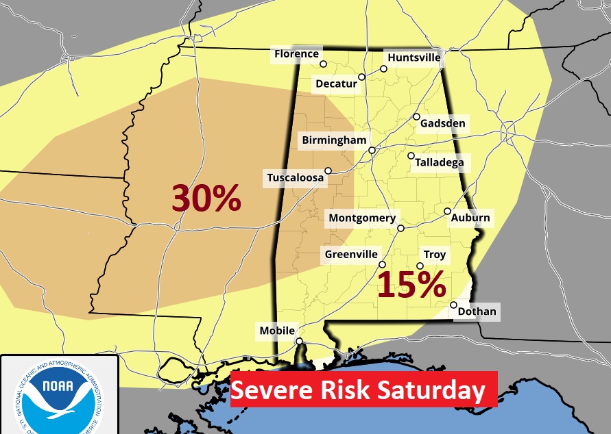
SPC has been advertising a Saturday night Severe Weather Threat for three days now. That 30% upgrade in west Alabama is disturbing and significant.
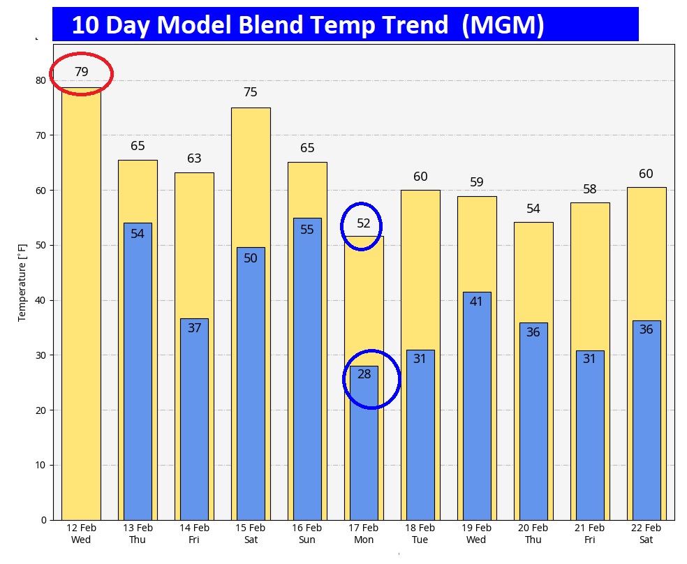
Here’s the 10 day model blend temperature trend. Today is the warmest. Obvisoloy a much cooler pattern is on the way. The coldest day appears to be next Monday.
Thanks for reading this special blog update. This morning everything is normal. We’ll be LIVE on NewsTalk 93.1. There will be another Blog Update and Forecast Video discussion in the 4’o’clock hour tomorrow morning. Have a good day.
–Rich