
Good Morning! All signs continue to point to a likely significant and extremely dangerous Severe Weather / Tornado Outbreak this afternoon and tonight, including all modes of Severe Weather. There’s even a risk of a few potentially strong to severe storms in the early this morning through about 8AM.
The afternoon/evening threat includes damaging wind gusts 75+ mph, possibly several tornadoes, including the risk for violent (EF-2+), long-track tornadoes 25+ miles track), along with the potential of large hail up to tennis ball size. Make sure you have at least 2 reliable ways to receive warnings. Get our weather App and allow notifications. Go to the App store and search Rich Thomas Weather. Make sure your Weather radio is plugged up and in the alert mode. Do not trust Tornado Sirens as a means for you to get a warning.
On Sunday, behind the storms system, mostly sunny weather returns. Here’s my brief video forecast discussion.
TODAY: Chance of a few showers/locally strong storms through early this morning. Then, Showers and Storms become likely, especially late afternoon and through tonight into the wee hours. Many storms severe. Damaging straight-line winds and strong, long-track tornadoes Wind advisory in effect for SE wind 15-25 gusting to 45 mph. High today 81. Low tonight 61.
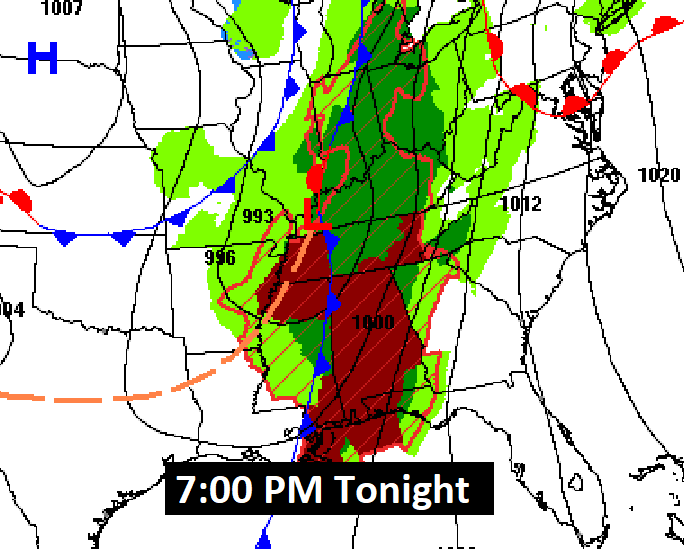
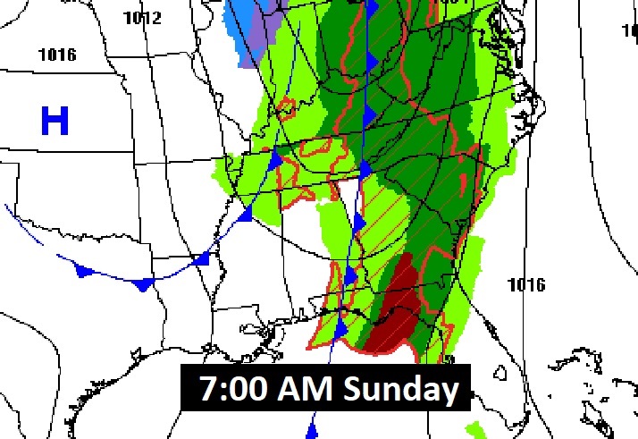
Early this morning several tornado warnings have been issued for northwest Alabama. Here’s the map set-up for 7PM tonight. By 7AM tomorrow morning, one cold front will have just about exited the state as the Severe Threat spreads eastward to the Southeast US coastline.
SEVERE OUTLOOK DETAILS:
A significant and extremely dangerous Severe Weather / Tornado Outbreak is likely this afternoon and tonight, including all modes of Severe Weather. The threat includes damaging wind gusts 75+ mph, possibly several tornadoes, including the risk for violent, long-track tornadoes. SPC says even some EF-4 tornadoes are a good bet. An amazing statement. Also, the potential for large hail up to tennis ball size.
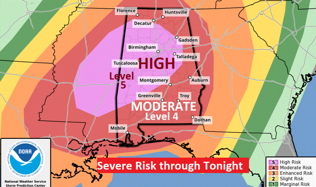
The Storm Prediction Center now has a Level 5 High risk covering much of central and west central Alabama. RARE. The rest of the state is still under a significant Moderate Risk (Level 4 out of 5)
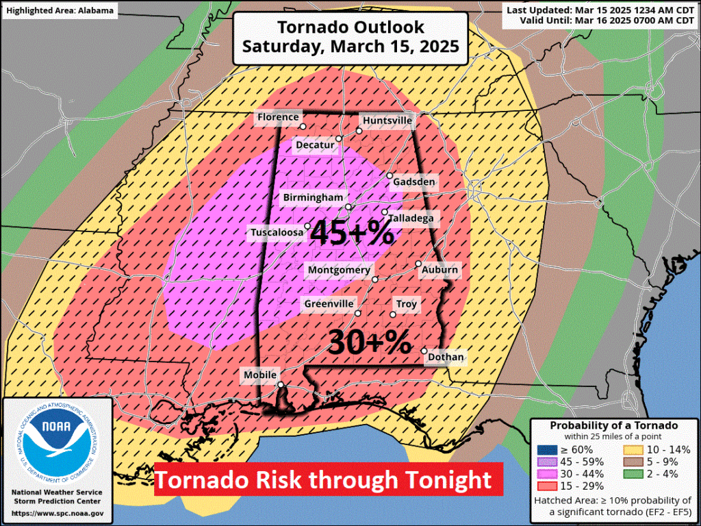
This is the updated Tornado Risk Outlook for today and tonight. The hatched area covers all of Alabama where there could be some strong to violent (EF-2+), long-track (25+ miles) tornadoes. SPC says even EF-4 tornadoes are expected in today’s rare and dangerous outbreak. Thes strongest risk of the most high end destructive tornadoes extends from central Alabama into west central Alabama and into Mississippi.
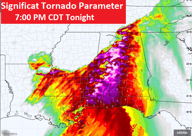
Here’s the Significant Tornado Parameter map. The numbers are very high for nearly all our state except the very far eastern counties near the GA border. The numbers in west Alabama are off the scale. Extremely high. It’s likely that TORNADO WATCHES today will include the tag Particularly Dangerous Situation. (PDS)
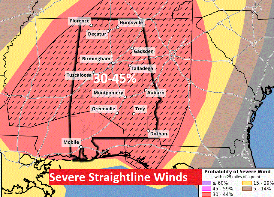
Damaging straight-line winds 75+ mph will be widespread as the storms spread eastward this afternoon and tonight. Individual supercells will be racing northeast at up to 70 mph.
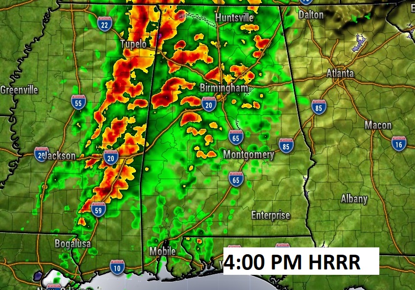
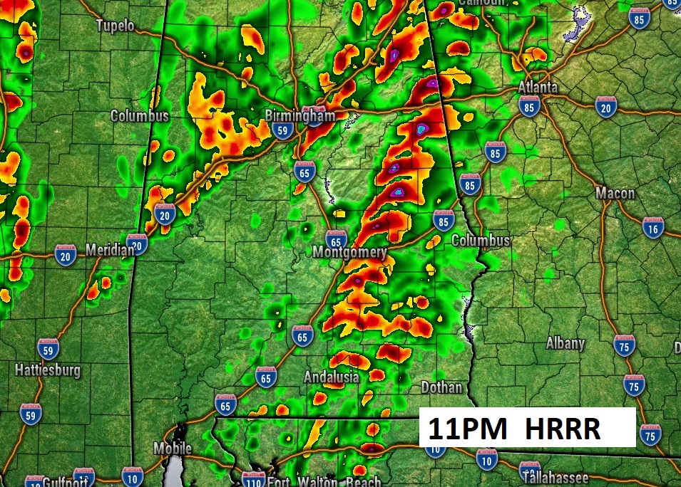
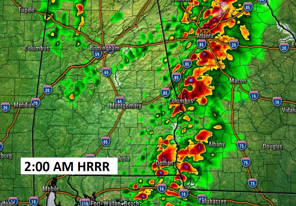
Here are some Future Radar samples from the HRRR model. The 4PM and 8PM frames are sobering showing multiple dangerous super cells.
Late tonight the greatest danger begins to shift eastward, eventually out of the state after 2AM.
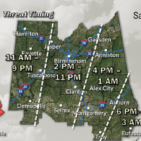
Here’s the lastest Timing guidance from NWS.
Here is the detailed Technical Forecast discussion from NWS Birmingham (BMX):
https://forecast.weather.gov/product.php?site=NWS&product=AFD&issuedby=BMX
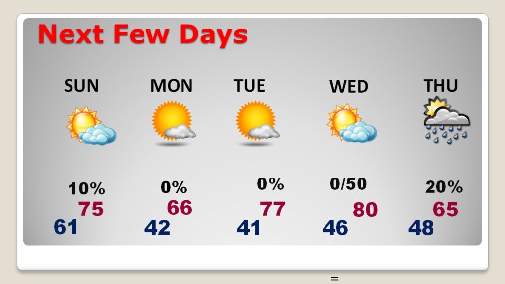
NEXT FEW DAYS: Following the Severe Weather Event Saturday night, mostly sunny weather returns Sunday. Still WINDY. Dry weather Monday and Tuesday. The next risk of showers & storms arrives by Wednesday night into Thursday.
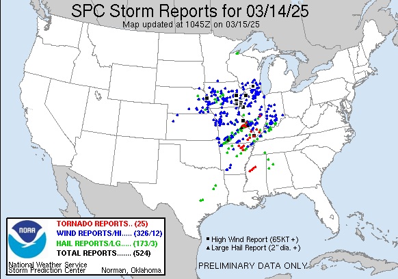
Here’s what has happened in just the last 24 hours through 5:30AM.
Let’s try to save lives today. Help us get the word out!
Thanks for reading this blog update. Stay up to date on the latest information during this potentially dangerous, possibly life threatening situation. I am planning to do another Facebook LIVE at about 11AM. That’s the plan right now.
–Rich