
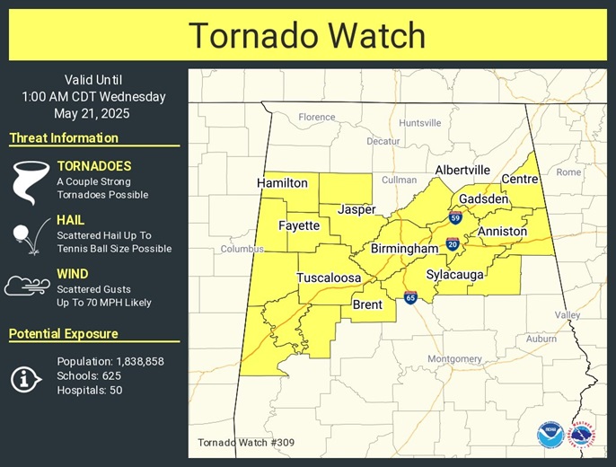
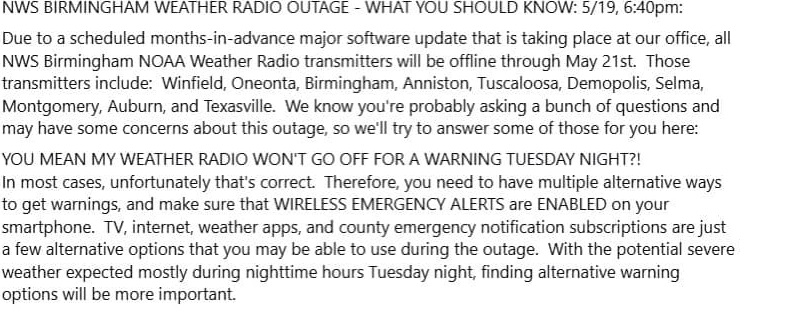
Tornado Watch continues for north Alabama till 1AM. A couple of strong tornadoes are possible. Scattered wind gusts to 70 mph are likely. Hail up to tennis ball size is possible. Additional watches and warnings are a good bit later farther south. Please make sure to allow notifications on our Weather App. If you do not have our weather app, you can download it in the app store. Search: Rich Thomas Weather. The National Weather Service will be upgrading their software at their office today through Wednesday. Unfortunately, that means that all their weather radio stations operated by the Birmingham Weather office will be off the air starting this morning and continuing until sometime Wednesday. So with severe weather moving into the state tonight, you need to know that the weather radios will not be operating.
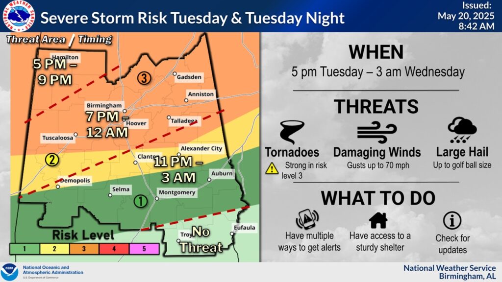
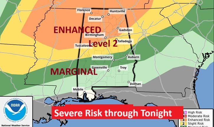
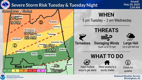
- The Enhanced Risk (Level 3 of 5) has been expanded further south across the region.
- Our tornado threat has increased. A few strong tornadoes are possible.
- Bumped up the start time by an hour for the Birmingham area based on latest trends.
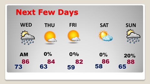
Good morning! Today will be the last hot and humid day. The daytime hours will be dry and quiet. A powerful line of strong/severe storms will enter the state by sunset, ahead of a cold front. The storms will move southward in the late night hours, reaching the US 80/I-85 Corridor by the wee early morning hours. Level 1 Marginal Severe Risk as far south as about Montgomery. Threat of damaging wind gusts. North Alabama has a Level 3 out of 5 Enhanced severe risk. Tornadoes can not be ruled out. The front will deliver some cooler, much less humid air by mid and late week. Highs Thursday and Friday will reach the lower 80’s. Lows will fall to the upper 50’s by Friday and Saturday mornings. We should be storm-free and nice Wednesday through at least Saturday. The next risk of scattered storms begins Sunday. So far, the Memorial Day forecast looks potentially wet and stormy, especially by afternoon. Here’s my brief video forecast discussion.
TODAY: Morning cloudiness. Then, asun/clouds mix. Hot today. High 92. Mostly Cloudy tonight. Showers and locally strong/severe storms by late tonight. Low 70.
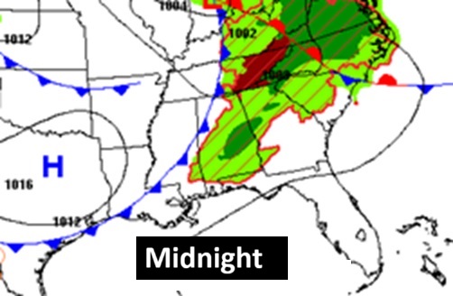
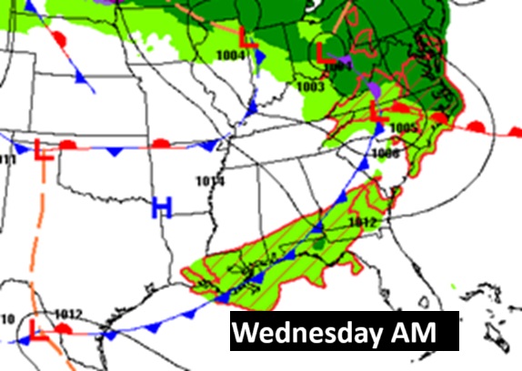
The front will move through the state overnight tonight and reach extreme south Alabama by morning.
The Storm Prediction Center has a Level 1 Severe Risk almost as far southeast as Montgomery Tuesday night. The threat escalates to a Level 3 risk in northwest Alabama beginning Tuesday afternoon. A couple of tornadoes can’t be ruled out.
Weather radio outage: The National Weather Service will be upgrading their software at their office today through Wednesday. Unfortunately, that means that all their weather radio stations operated by the Birmingham Weather office will be off the air starting this morning and continuing until sometime Wednesday. So with severe weather moving into the state Tuesday night, you need to know that the weather radios will not be operating. That’s why you need our weather app on your phone or tablet if you do not have it already. You can find it in the App Store, but just search searching Rich Thomas Weather.
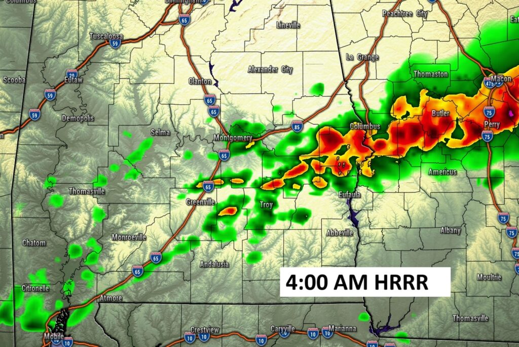
FUTURE RADAR: The strong line of strong/severe storms (QLCS) will slide through the Birmingham area late tonight reaching the Montgomery area by the early morning hours.
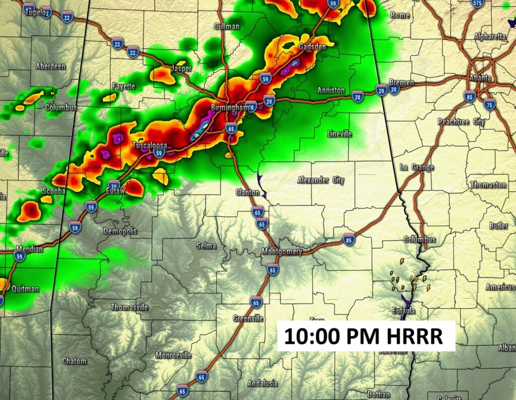
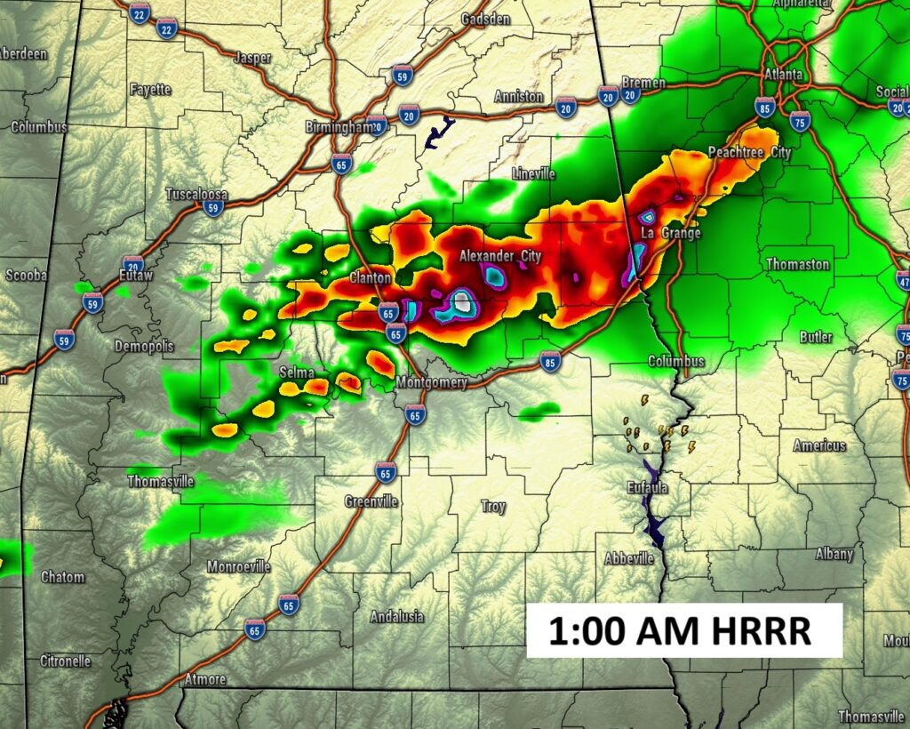
Severe Weather Time Table.
NEXT FEW DAYS: That front will bring storms tonight, will also deliver some cooler, much less humid air. Highs Thursday and Friday will reach the lower 80’s. Lows will fall to the upper 50’s by Friday and Saturday mornings. We should be storm-free and nice Wednesday through at least Saturday. The next risk of scattered storms begins Sunday. So far, the Memorial Day forecast looks potentially wet and stormy, especially by afternoon.
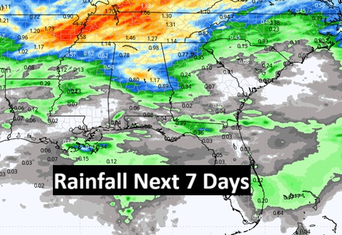
Here’s the rainfall potential map. This includes the rain tonight and the Memorial Day storm system.
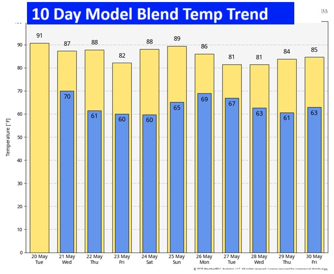
10 Day model blend temperature trend. Normal hi/lo 87/6
Thanks for reading the blog. Today everything is normal including LIVE on the Radio of NewsTalk 93.1 WACV. There will be another video forecast discussion and Blog Update in the 4 o’clock hours tomorrow morning. You can always find my forecast updates hourly on the 8 station Bluewater family of stations every day of the year.
–Rich