
Good morning! Fall officially begins early this afternoon. It’s the Autumnal Equinox. But, Summer heat and humidity is locked in through mid-week. Expect low to mid 90s today, Tuesday and Wednesday. Rain chances are not zero, but very small. Under 20%. But there’s big news in the week ahead. An important cool front is on the way. The front will bring a chance for widespread showers and thunderstorms, followed by dose of some really nice air. The best chance of rain will be Thursday. Some storms could be quite strong. The first weekend of Fall will feature much lower humidity and cooler nights. Hang on. Here’s my brief video forecast discussion,
TODAY: Mostly sunny. A little more humid. Rain chance under 20%. High in the low to mid 90’s. Mostly clear tonight. Low near 70.
NEXT FEW DAYS: Hot and humid through Wednesday with highs in the low to mid 90’s. Rain chances are very small until late Wednesday night. An important cool front is on the way. The front will bring a chance for widespread showers and thunderstorms, followed by dose of some really nice air. The best chance of rain will be Thursday. Some storms could be quite strong. The first weekend of Fall will feature much lower humidity and cooler nights.
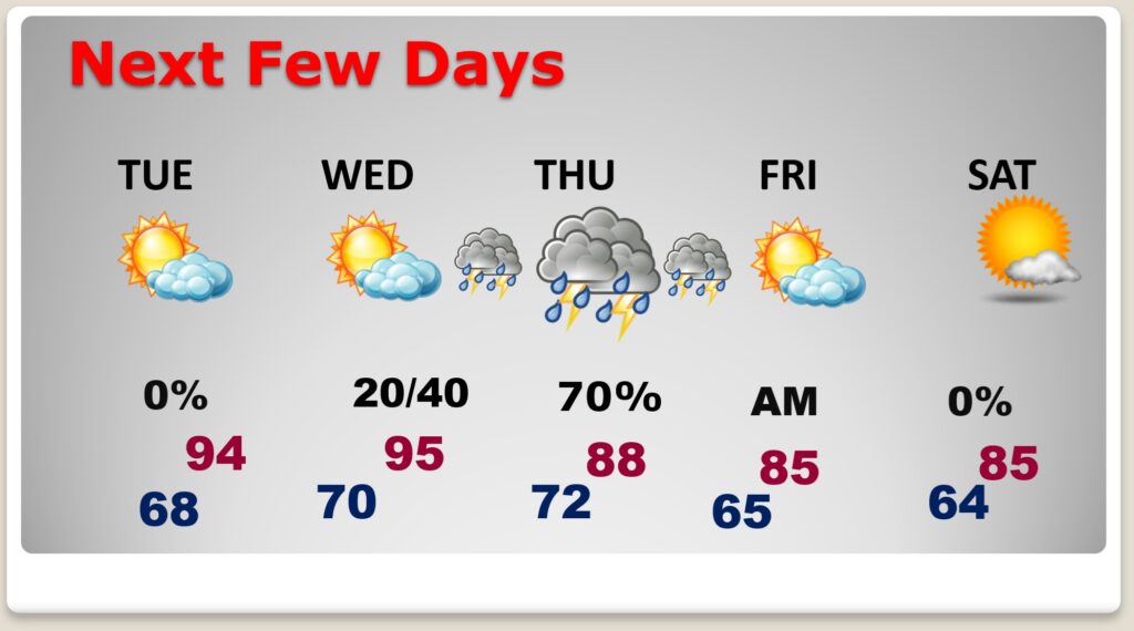
Some storms could be strong to severe. There is a Level 1 Marginal Severe Risk late Wednesday night through 7AM Thursday for the western half of our state. Eventually that threat could spread to the rest of the state Daytime Thursday.


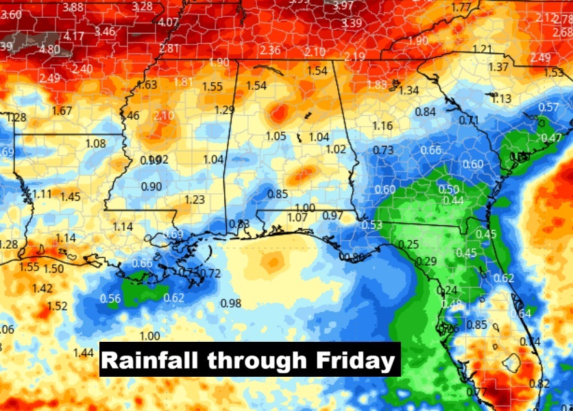
Here’s the projected rainfall through thew next 7 days. Good news. The approaching cool front will bring widespread showers and storms late Wednesday night and Thursday. Some towns could see more than an inch of rain.
Here’s the 10 Day Temperature Trend. The 90’s are likely through Wednesday. But this week’s cool front will bring a nice change by the end of the week. The first weekend of Fall will feature much lower humidity and cooler nights. Stand by.

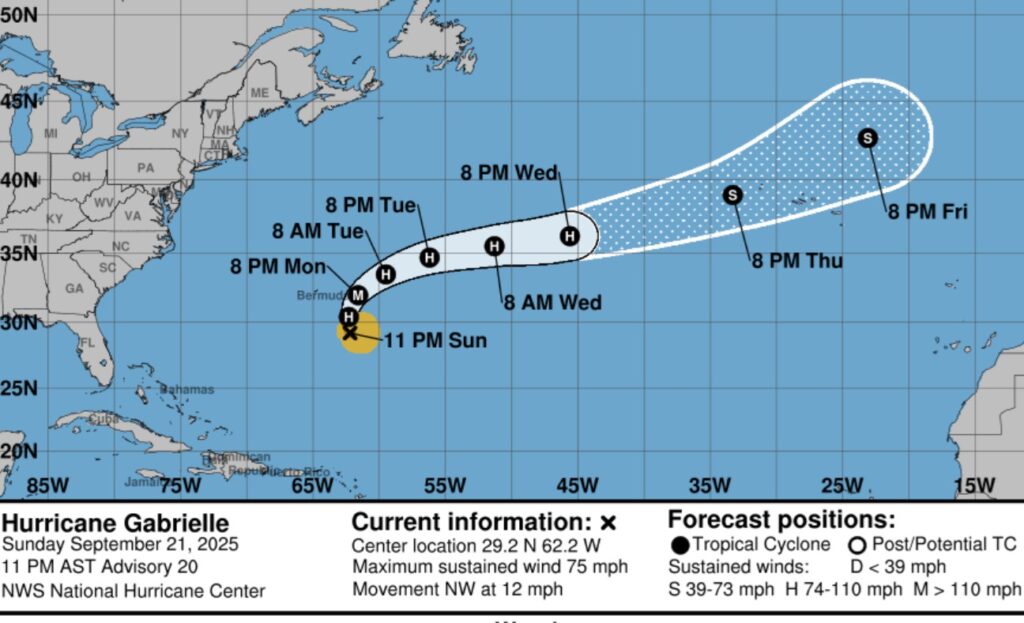
TROPICAL OUTLOOK: The Atlantic is getting much more active. Gabrielle is now a Hurricane. It will take a right hand curve into the central Atlantic, away from land.
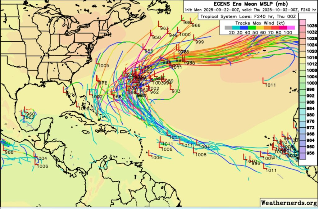
Elsewhere there are two Areas to Watch. One with a 60% chance of development. The next available name is Humberto.

Here’s the EURO Ensemble Member Lows through the next 10 days. MOST activity in the Central Atlantic. But we’ll also keep our eyes off the SE US coast and the SW Gulf.
AUTUMNAL EQUINOX: Fall officially begins at 1:19 PM CDT.

Thanks for reading the blog. Today everything is normal including LIVE on the Radio of NewsTalk 93.1 WACV. There will be another video forecast discussion and Blog Update in the 4 o’clock hours tomorrow morning. You can always find my forecast updates hourly on the 8 station Bluewater family of stations every day of the year.
–Rich