
TORNADO WATCH Till 6:00PM
A Tornado Watch is now in effect for much of central Alabama, as far east as Montgomery and Elmore counties until 6PM. Damaging wind gusts to 60 mph, large hail (up to quarter size) and a couple of tornadoes possible. If you live in a mobile or manufactured home go to a safer structure during this tornado watch. Our weather App will keep you up to date with instant push notifications for Severe Weather Warnings. Plus, radar and future radar. It’s FREE in the App store. Search: Rich Thomas weather. Allow notifications. Stay Weather Aware! #alwx

11:45 AM UPDATE:
SPC: 40% chance of a Tornado Watch. Area outlined more favorable for potential tornado development through 2:15 PM CST. ****SPC NOW LEANING TO A Tornado Watch.
https://www.spc.noaa.gov/products/md/md2231.html
8AM UPDATE:
SEVERE WEATHER TIMING UPDATED: There is a level 1-2 (out of 5) risk for a second round of severe thunderstorms through 12 midnight in advance of our next frontal system. The risk area for round 2 is for most of Central Alabama, first in the morning across the northwest counties, then throughout the day and past sunset for the central portions. Finally, the southeast counties timing is expected to be in the afternoon and into the late evening. The threats include damaging winds, an isolated/brief tornado or two, and large hail. Remember to have multiple ways to get alerts, have access to a sturdy shelter, and check back for updates.

Good Morning! Big weather changes begin today. An approaching Cold front will bring the risk of strong/severe storms to the state today. SPC has issued a Level 2 out of 5 Severe Weather Risk covering most central Alabama through tonight. Damaging winds and large hail will be the main threats. A few brief, Isolated tornadoes can’t be ruled out.
A big temperature drop will follow starting Wednesday. Wednesday night will be Colder in the 30’s. Thanksgiving will be chilly with highs in the 50’s. It will be quite cool though Iron Bowl weekend with Cold nights. Here’s my brief video forecast discussion.
TODAY: Mostly cloudy, with a high near 79. South winds gusting as high as 20 mph. Scattered showers and thunderstorms possible anytime today or tonight. Primetime for some of the strongest (possibly Severe storms) in the afternoon and evening and tonight. Storm risk fades out at Midnight or there abouts. Mostly cloudy tonight. Low 58.

SPC has issued a Level 2 out of 5 Severe Weather Risk covering most central Alabama through tonight. Damaging winds and large hail will be the main threats. A few brief, Isolated tornadoes can’t be ruled out.

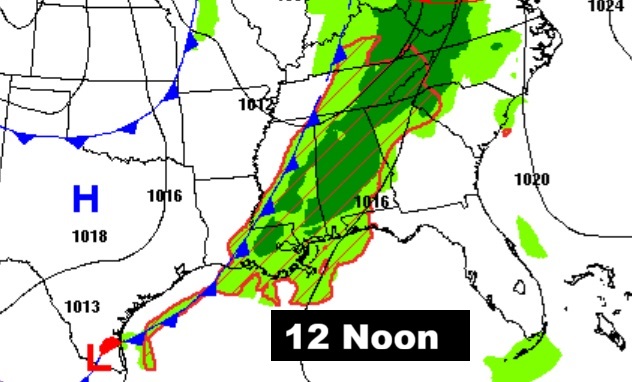
This is graphic is helpful to show a very general timeline of the greatest severe risk today.

FUTURE RADAR: The strongest severe risk will be along a squall line of strong/severe storms from late afternoon in through the evening hours and tonight.


NEXT FEW DAYS:
It will turn sharply colder. By Wednesday night we’ll be in the 30’s. Thanksgiving will be chilly with highs in the 50’s. We’ll be close to a freeze by Black Friday dawn. It will be quite cool though Iron Bowl weekend with Cold nights. (Normal hi/lo 67/41) The next chance of rain will be in the Sunday/Monday time frame.

THANKSGIVING: Quite cool. Brisk. Mostly sunny. Morning low 38. Daytime high only 56. Low Thursday night 32.

Here’s expected rainfall. The first graphic shows the rainfall through tonight. The other graphic shows the combined potential rainfall for the next 7 days.


Here’s the 10 Day Model Temperature Trend. Coldest Wednesday night through Iron Bowl Saturday. There will be some recovery next week.

IRON BOWL: The biggest game of the year in Alabama will take place in Auburn this season, kicking off at 6:30 p.m. on Saturday. The forecast calls for clear, cold conditions, with temperatures dropping through the 40s during the game. Saturday’s high in Auburn 55. Low Saturday night 40.
Thanks for reading this Blog this morning. This morning we are LIVE on the radio from 6 to 9 on NewsTalk 93.1. I’ll have another update for you in the 4 o’clock hour tomorrow morning. Stay weather aware.
–Rich