
MONDAY PM UPDATE:
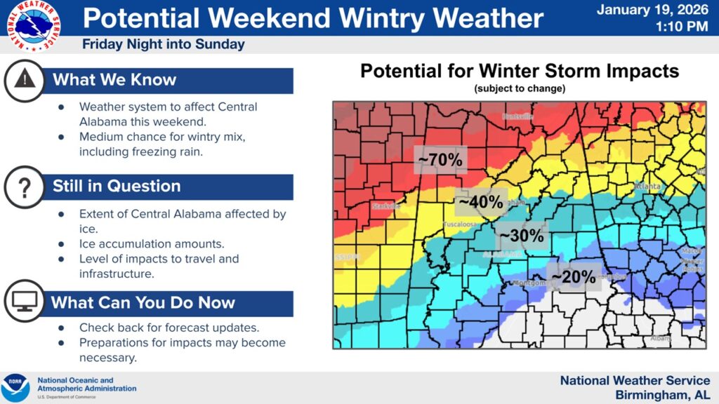
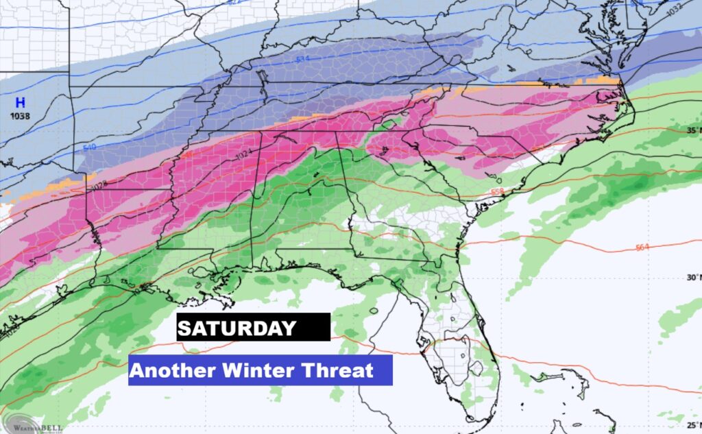
There is growing concern. A wintry mix, including ice, could affect parts of north and Central Alabama this weekend. On top of that, some locations could be dealt a blast of frigid temperatures. Details regarding who gets what, and impacts, should become more apparent as we get a bit closer. Looks like Alabama will be dealing with something… especially over the northern half of the state. But, how much, and how far south? Time will tell. REMEMBER: in the whole world of Winter Weather- there is nothing more serious than a Freezing Rain risk.
I’ll have much more for you with a video forecast discussion and detailed Blog update in the morning. Stay tuned.
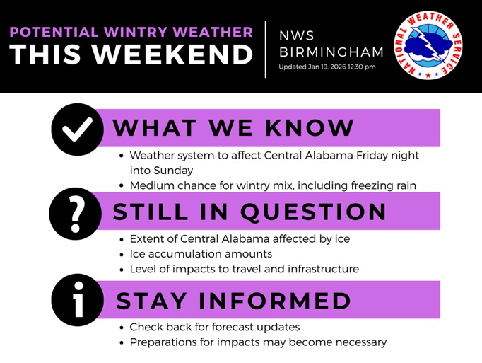
Now we’ve an early look, graphically, at the upcoming system. Again, it’s too early to pinpoint details but, based on the overall setup, there is increasing confidence for impacts near and north of the 20 corridor. All locations should monitor for shifts in probabilities.
A worst case scenario involves significant impacts to travel and infrastructure from icing, with compounding impacts due to frigid temperatures for those that experience power loss.
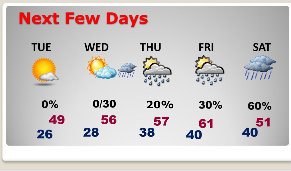
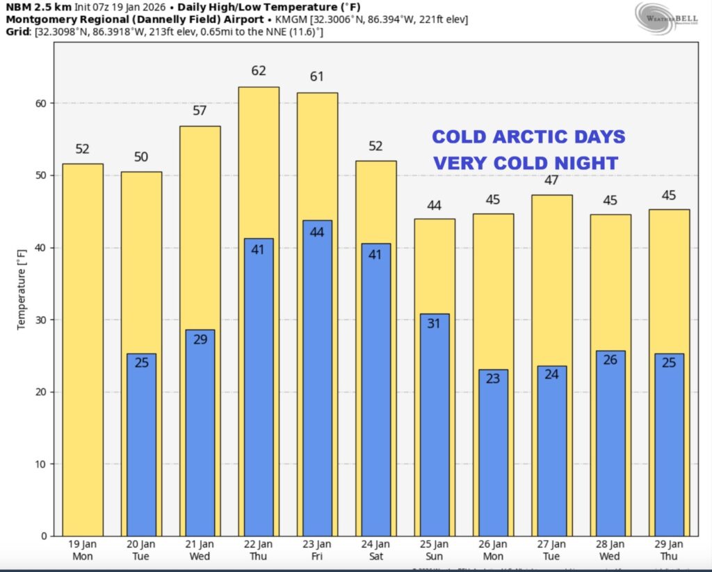
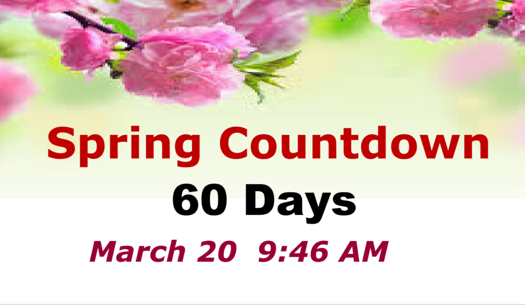
Good Morning! It’s a very chilly MLK Holiday forecast. Not only that. Nights continue very cold. Today and Tuesday’s highs will struggle to reach 50. Look for 20’s again tonight. (Normal 60/36). Late week warming will take us to the lower 60’s by later in the week. Scattered showers return to the forecast Wednesday night through Saturday. Another shot of much colder air arrives over the weekend. Sixty days till the start of Spring. Here’s my brief video forecast discussion.
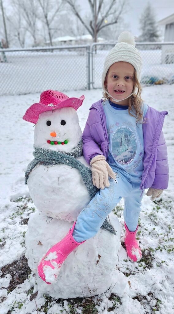
ANOTHER EXTREMELY RARE SOUTHERN SNOW EVENT:
The Sunday morning snow event played out just about as expected. This from 10 miles north of Ozark Sunday morning. Do you think this little girl is absolutely thrilled?
Over the border, Mariana, Florida and Tiffton, GA had 3”. Amazing.
TODAY: Sunny, with a high near 50. Northwest wind 5 to 10 mph.
TONIGHT:
Mostly clear, with a low around 25.
NEXT FEW DAYS: Tuesday we probably won’t make it out of the 40’s. Down to the middle 20’s Tuesday night. Not quite as chilly Wednesday with highs into the 50’s. Scattered showers return to the forecast Wednesday night through Saturday. Late week warming will take us to the lower 60’s by later in the week. Another shot of much colder air arrives over the weekend.
More winter drama is parts of the South by Saturday. Stand by…
Here’s the model blend 10 day temperature trend. Warmest late week. But, then another disappointing extended Arctic Pattern.
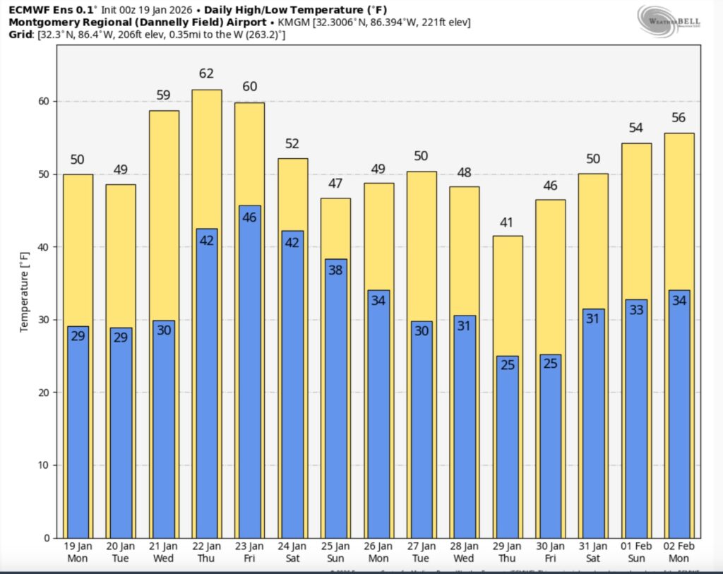
Here’s the EURO 16 day Ensemble temperature outlook. (Normal 60/36).
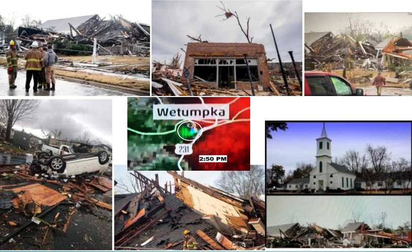
TORNADO ANNIVERSARY: Major EF-2 on this date 7 years ago today. It was Saturday, January 19, 2019. just before 3:PM. Significant damage in Elmore county from Wetumpka to Eclectic.
The extent of damage done to multiple structures in Wetumpka indicated a tornado with high-end EF-2 wind speeds. The degree of damage included: collapse/failure of exterior walls, significant damage to interior walls, roof failures, shifting of structures, and collapse of structures due to direct and indirect causes. Several vehicles were also tossed or rolled, with debris puncturing framing. Trees were also snapped and uprooted. The First Presbyterian Church was destroyed, but rescue/clean-up efforts precluded an accurate assessment of damage.
The tornado continued northeastward, crossed the Coosa River, and then paralleled State Route 170 as it continued to damage structures and snap and uproot trees. The tornado cycled as it moved northeast into the northern portions of the town of Eclectic, evident via a new radar TDS (tornado debris signature) and fluctuating degree of damage. The tornado dissipated just before Lake Martin, near Holly Mill Road.
All EF-2-level damage occurred from downtown Wetumpka to the eastern banks of the Coosa River.
https://www.weather.gov/bmx/event_01192019wetumpka


DAYS TILL SPRING: 60 days!
Thanks for reading this Blog this morning. This morning we are LIVE on the radio from 6 to 9 on NewsTalk 93.1. I’ll have another update for you in the 4 o’clock hour tomorrow morning. Have a nice day.
–Rich