
11:30AM UPDATE:
Upgraded Sunday Level 2 Severe Weather Threat
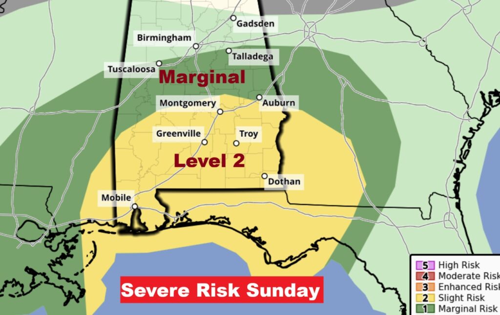
Unfortunately, The Storm Prediction Center has upgraded the Sunday Severe Weather Risk – and expanded the threat area. Just added: Level 2 Severe Risk added from Elmore county southward to the coast. The Level 1 – Marginal Risk has been expanded northward to a Talladega/Tuscaloosa line. While Damaging winds 60+ mph is the main threat, the Risk of a few tornadoes has increased, especially in the Level 2 threat area. The primary threat window would be from late morning through much of Sunday afternoon. Our Weather App will keep you on top of the action with instant push notifications for Severe Weather Threats for your location. It’s FREE in the App store. Just search Rich Thomas weather. A Drastically colder Arctic plunge will follow Sunday night. Stay Weather Aware.
Here’s the expected timing on the Sunday Severe risk.

EARLY MORNING UPDATE:
Good Morning! As you know, a storm of Historic proportions, on many levels, will assault an enormous area of our country – a 2300 mile corridor from Texas/Oklahoma/Louisiana to the state of Maine. By far the most concerning aspect will be a crippling Ice Storm in two zones: 1) Parts of LA/MS could see .50 to .75” accumulating ice. Historic. Unthinkable. Crippling. A second Ice Zone could cause extreme impacts in parts of Georgia including Metro Atlanta. Parts of north Alabama are under various alerts in the extreme northern counties. More on that below. Rain begins for us this afternoon and becomes likely and heavier tonight. The main event for a lot of us will be Sunday with Rain and maybe strong/severe thunderstorms. There is a Marginal Severe Risk, which covers all of southeast Alabama including the Montgomery area, southeastward. Much colder air moves in Sunday night. There could even be a brief Wintry Mix locally, before the precipitation ends Sunday night. An Extreme Cold Watch Begins Sunday night. Wind chill will be a big factor. Any puddles on the roads from the Sunday rain will freeze overnight Sunday, which could make for some hazardous travel in spots on Monday morning.
Monday will be an Arctic Cold day. We will; be in the teens Monday night. Bitter Cold Arctic Air will dominate our forecast for several days. There’s so much more details contained in this Blog update with lots of graphics.
TODAY: Scattered showers after 3pm. Mostly cloudy, with a high near 58. East wind 5 to 10 mph, with gusts as high as 20 mph.
TONIGHT: Rain likely. Low around 50. East wind around 10 mph, with gusts as high as 25 mph.
SUNDAY: Rain and thunderstorms likely. High near 70. Southeast wind 10 to 15 mph becoming west in the afternoon. Winds could gust as high as 30 mph. Level 2 Severe Risk especially 11AM to 4PM. Locally heavy downpours.
Rainfall amounts could be excessive in spots.

SUNDAY NIGHT: Extreme Cold Watch begins. Extreme temperature drop. Precip. Should end by Midnight. (Brief Winter mix before the precipitation ends? TINY chance) Then Windy and sharply colder.
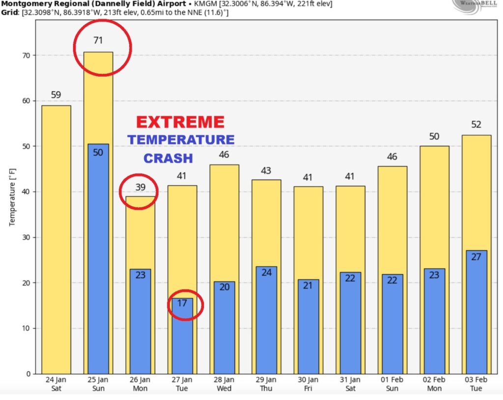
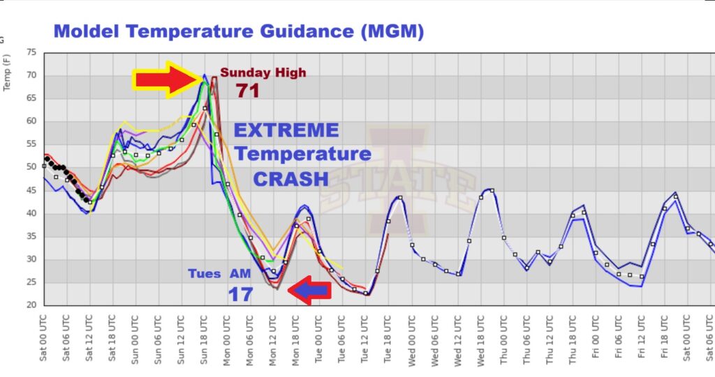
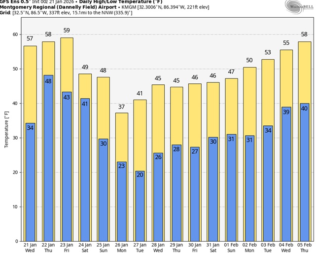
Here’s the model blend 10 day temperature trend. I want you to look at the change in temperature from near 70 Sunday to teens Tuesday Dawn. Over 50 degree drop. I mean …just WOW. Bitter Cold Arctic Air will dominate our forecast for several days.
NEXT FEW DAYS: Just to recap: The main event for a lot of us will be Sunday with Rain and maybe strong/severe thunderstorms. There is a Marginal Severe Risk which covers all of southeast Alabama including the Montgomery area, southeastward. Much colder air moves in Sunday night. There could even be a brief Wintry Mix locally, before the precipitation ends Sunday night. An Extreme Cold Watch Begins Sunday night. Wind chill will be a big factor. Any puddles on the roads from the Sunday rain will freeze overnight Sunday, which could make for some hazardous travel in spots on Monday morning.

Dangerous Wind Chill Monday morning. Crazy numbers.
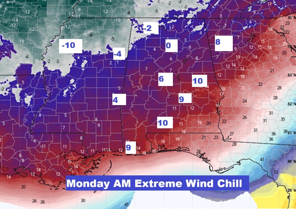
Monday will be an Arctic Cold day. We will; be in the teens Monday night.
DANGEROUS MAJOR MULTI-STATE WINTER STORM:
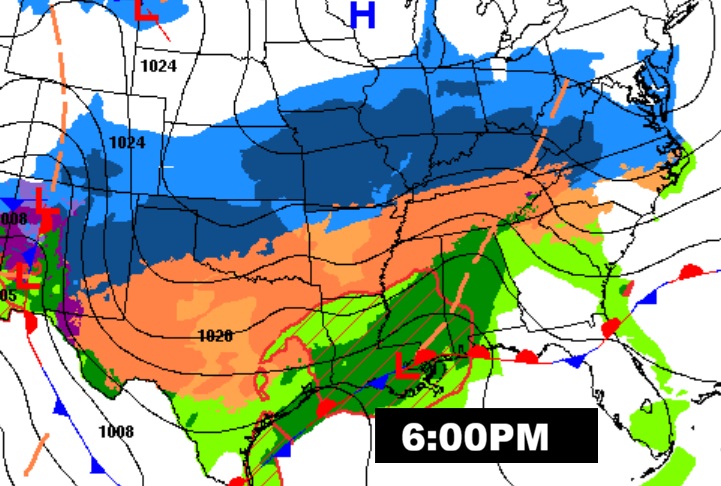
Look at the extent of Winter Weather Alerts from Texas to the middle Atlantic coastal states. I’ve never seen this much of America ever covered by this many winter weather alerts.
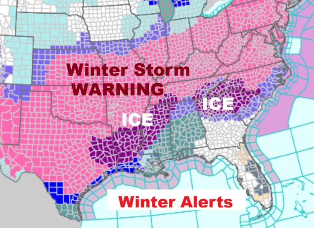
The Ice Storm Threat for could clip parts of NW Alabama. . Some of the main aspects will be in the extreme northern part of the state. There are various Winter Alerts covering extreme north Alabama.

ICE STORM: By far the most concerning aspect will be a crippling Ice Storm in two zones: 1) Parts of LA/MS could see .50 to .75” accumulating ice. Historic. Unthinkable. A second Ice Zone could cause extreme impacts in parts of Georgia including Metro Atlanta.
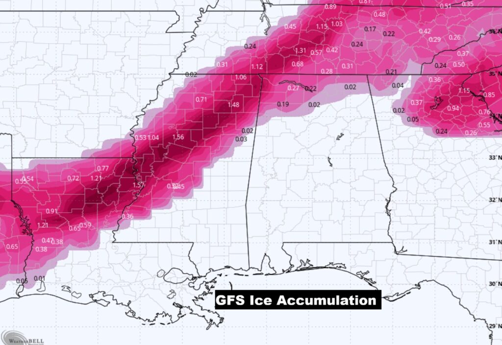
Besides the ICE STORM threat, look at that band of locally very heavy snow. Some of the snow totals will be crazy over a multi-state area.

Here’s the EURO 16 day Ensemble temperature outlook. (Normal 60/36).
.
.
DAYS TILL SPRING: 55 days!
Thanks for reading this Blog this morning. Have a great weekend.
-Rich