Can you imagine a stretch of maybe 6+ days with no storm systems to worry about? In March? It is hard to imagine, after such an active few weeks. If the week ahead is YOUR Spring Break week, you hit the jackpot. We’ll also look farther ahead. How long could this quiet pattern possibly last?
TODAY: High level clouds will limit sunshine, but I’ll call it “partly sunny”. A Cool day for March. The average high is 70. Today’s high will struggle to reach 60. Breezy. North winds at 10-16 mph. Mostly cloudy, chilly tonight. Overnight low near 40.
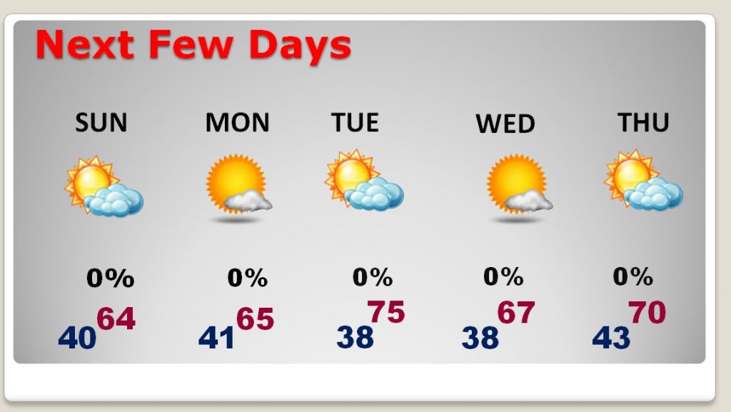
NEXT FEW DAYS: A series of re-enforcing dry cool fronts will move through. That will keep us storm-free, but below normal temperature wise through the week. Coolest mornings will be Tuesday & Wednesday. There will be a lot of sunshine in the next few days. We’ll start to warm-up, close to normal, on the afternoon highs by about Thursday/Friday.

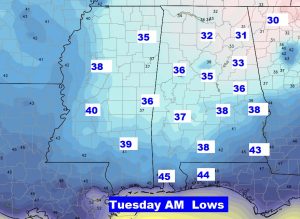
COUPLE OF COLD MORNINGS: Chilliest mornings will be Tuesday and Wednesday, when we could fall into the upper 30’s in central Alabama. (Average low is 45). There could be a frost or freeze in some counties across north Alabama. Here’s a peek at Tuesday morning near sunrise.

A LOOK BEYOND: Spring Breakers will love hearing that this storm-free pattern could last even well into next weekend, with some moderating temperatures. Timing of the next shower threat varies by which model you look at. The GFS shows showers by late March 24th, Sunday or Sunday night. The EURO is not very bullish on this system. That’s way out there. The point is, next weekend (March 23/24th), could, potentially, be pretty nice.
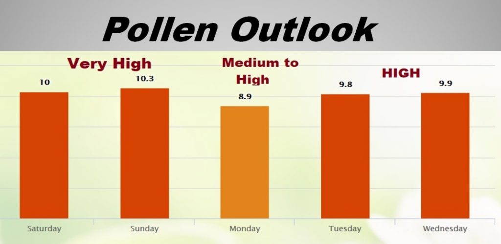
POLLEN FORECAST: The pollen count will remain in the very high range through the weekend, and medium to high on Monday. More high numbers are indicated for Tuesday & Wednesday.

TORNADO SURVEYS CONTINUE: The National Weather service started tornado surveys yesterday for Thursday night’s storms. Radar suggests there may be as many as 12 tornado tracks all-together. Yesterday, survey teams indentified 5 tornado tracks, including an EF-2 in Elmore county (120 mph winds), which touched down near Holtville and traveled for 8.5 miles (650 yards wide), causing significant damage but no injuries. There was an EF-1 tornado in Autauga county, and EF-1 in Chilton/Coosa, another EF-0 in Coosa, and 2 tornadoes in Blount county…and EF-0 and EF-1. Additional tornado surveys will continue all weekend. You can read the details of the surveys so far here: https://forecast.weather.gov/product.php?site=NWS&issuedby=BMX&product=PNS&glossary=1
– –
I hope you have a GREAT St. Patrick’s Day weekend. I’d like to point out…there are NO severe weather outlook maps from the Storm Prediction Center on today’s Blog!
I’ll have another blog update on Sunday morning, early. Enjoy the storm-free days!
-Rich
