10AM NHC UPDATE on the Remnants of FRED:
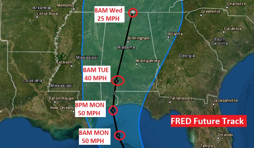
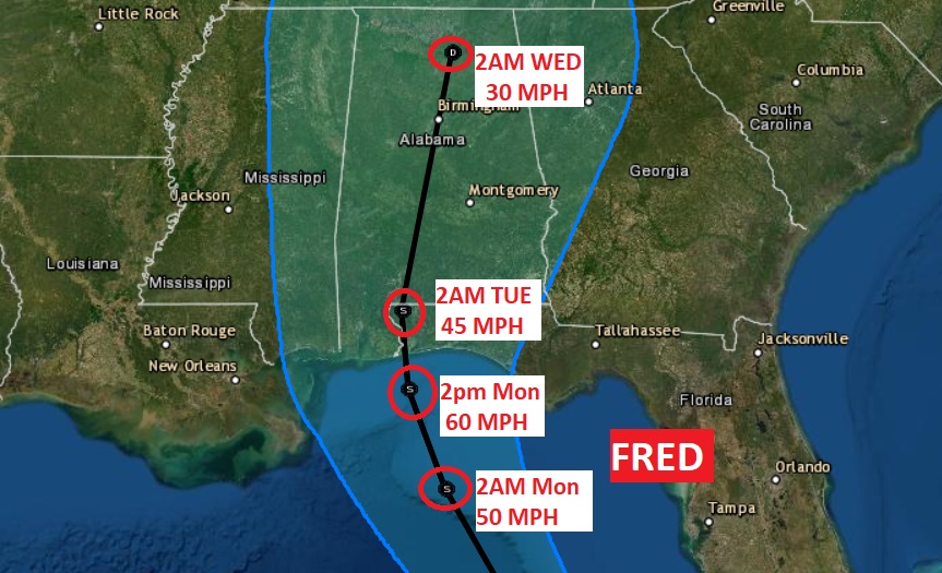
Fred has lost it’s Depression status. Disrupted by the Cuban landmass, it is now just an open wave, located near the Isle of Youth. It’s now called The Remnants of Fred. However, it is expected to reform a closed circulation over the eastern Gulf on Sunday. It will eventually become a Tropical Storm again Sunday night. Fred should make landfall on the northern Gulf coast Monday night either on the Alabama or NW Florida coast. It will trek through Alabama Tuesday, and be near the Alabama/Tennessee border Wednesday morning. For us it means the threat of tropical downpours, gusty winds, and the threat of a few tropical tornadoes, starting late Monday night into Tuesday.
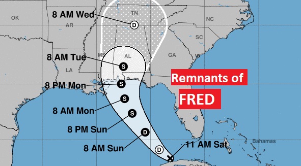
Here’s a close up on the cone and track and projected intensity.
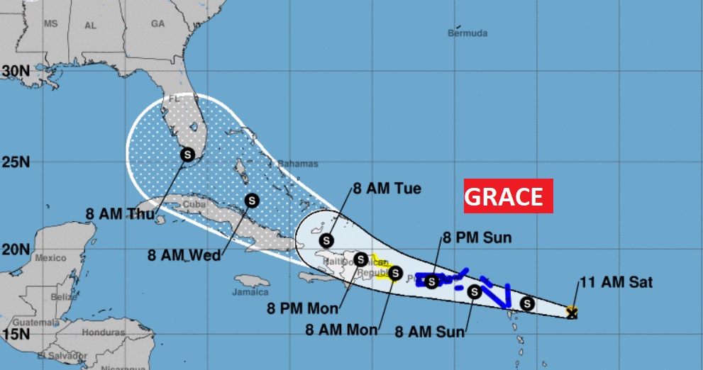
10AM UPDATE ON TROPICAL STORM GRACE:
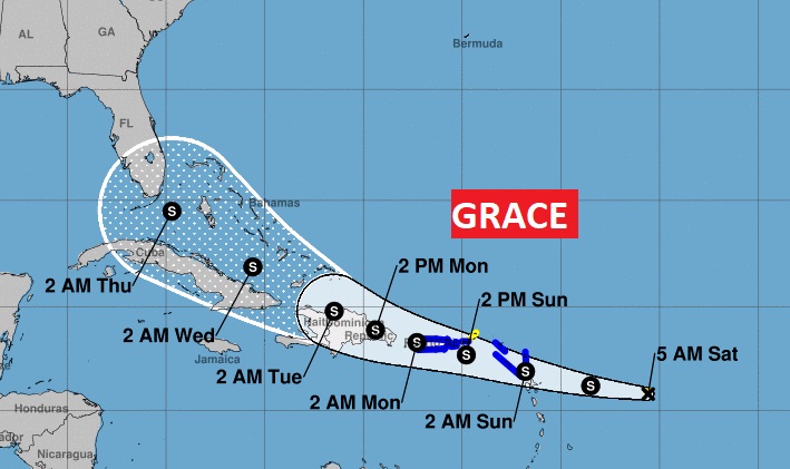
Tropical Storm Grace, located in the Tropical Atlantic, about 265 miles ESE of the Leeward Islands. Winds 45mph. Moving west at 23 mph. Should be near the Leeward Islands Tonight and near the US Virgin Islands and Puerto Rico by Sunday night and the Dominican Republic by Monday. The future track is similar to Fred, in that the system will pass north of Cuba into the southeast Bahamas by Wednesday. Could impact Florida by Thursday. After that Grace’s future track and intensity is unknown. Time will tell how much of an impact Grace could have on the United States. Stay tuned.
EARLY MORNING UPDATE:
Good Morning! The stakes, as far as Fred are concerned, have changed. My concern is growing. The track continues to evolve westward. The potential impacts for Alabama continue to grow. NHC has Fred as a strong Tropical Storm when it comes ashore late Monday night. But, I’m worried it could be a hurricane. Just a gut feeling. Certainly, for many of us, the impacts of Fred are escalating.
And, then…There has been a NEW birth in the Tropics this morning. It’s a girl. Say hello to Tropical Storm Grace. Grace may also have significant future impacts for the United States.
TROPICAL STORM FRED: Fred is pathetic this morning. They are calling it a Depression still, but it may not even be that. Disrupted by the Cuban land mass, it could just be an open wave. Air Force and NOAA Recon will investigate later this morning. The system will have a chance to regenerate over the Gulf Waters near the Keys and then, it should have ample opportunity to grow stronger in the warm Gulf of Mexico waters as it aims for the Alabama or Florida panhandle late Monday night or early Tuesday. NHC has it as a strong 60 mph Tropical Storm at landfall. As I mentioned above, don’t be surprised if it’s a bigger deal than that.
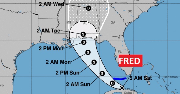
Interaction with Cuba has affected the potential track westward. Not good. Now many Alabamians could be on the stronger east side of the track.
Potential Fred IMPACTS are growing. This will continue to be updated between now and landfall. Heavy rain along and east of the track. The gusty wind forecast is escalating. Too early to assign numbers. Tropical Tornado threat. Stay tuned. The stakes are now higher for us.
BIRTH OF TROPICAL STORM GRACE: Behind Fred, Grace was just born as of 4AM CDT. Should be near the Leeward Islands Tonight and Near Puerto Rico by Sunday night and the Dominican Republic by Monday. The future track takes Grace into the Bahamas by Wednesday. Like Fred, interaction with the mountains of Hispaniola will disrupt Grace. There are some models that suggest Grace could have significant future impacts for the United States. Where? How strong? Stay tuned. Grace may have a very interesting future.
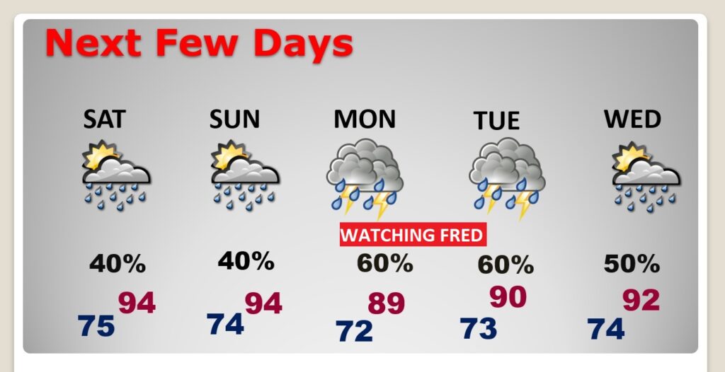
TODAY: Sun/Cloud mix. High 94. Heat index 100-104. Scattered random afternoon and evening storms. Low tonight mid 70’s.
NEXT FEW DAYS: Routine forecast Sunday. Monday and especially Tuesday/Wednesday forecast is subject to change with the approach of Fred.
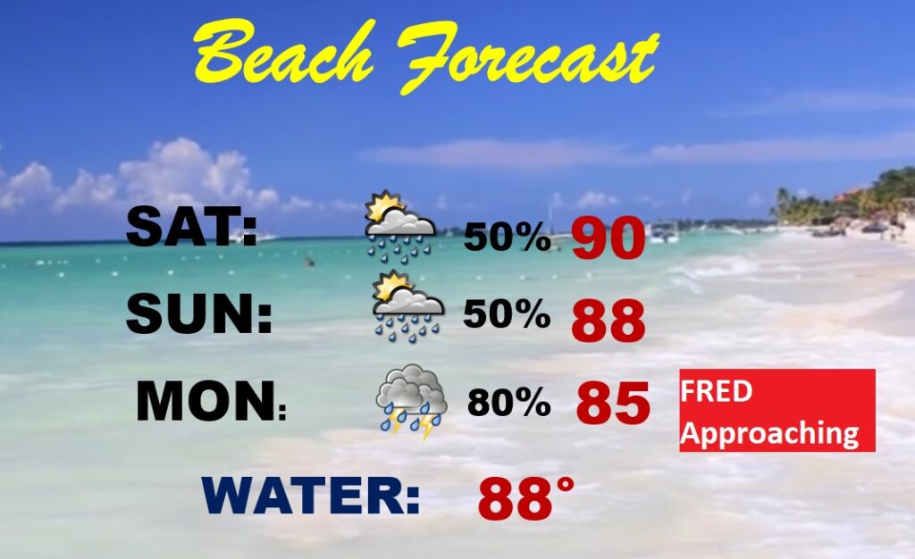
BEACH OUTLOOK: Routine today and Sunday. By Monday, most traffic will be moving northward from the coast as Fred approaches.
I’ll have another Blog update tomorrow morning. We obviously have much to talk about. Stay informed. Enjoy your weekend!
–Rich
