4PM NHC UPDATE on the Remnants of FRED:
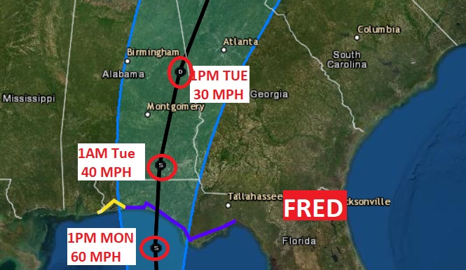
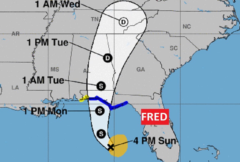
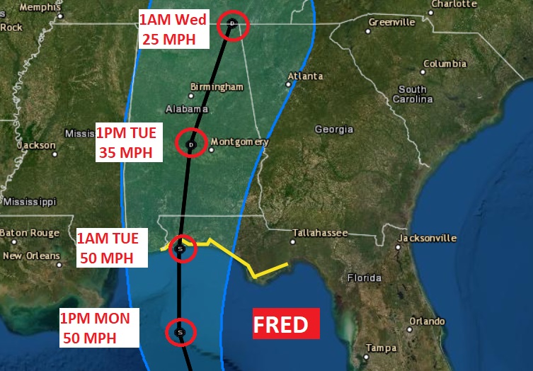
Tropical Storm Fred has become slightly stronger and better organized in the Gulf. Winds are now 45mph, moving NNW at 10mph. Fred is forecast to be a 60 mph Tropical Storm when it arrives on the on the western Florida panhandle Monday afternoon or Monday night. A Tropical Storm Warning has been issued from Navarre, FL. eastward through Panama City to the Florida Big Bend. Fred will move northward through Alabama Monday night & Tuesday. The center line of the cone has shifted about 50 miles eastward. Main impacts: gusty winds to 25 mph, tropical downpours and perhaps a couple of tropical sin-up tornadoes.
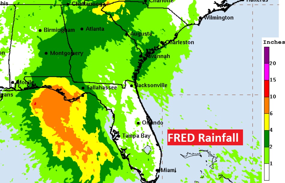
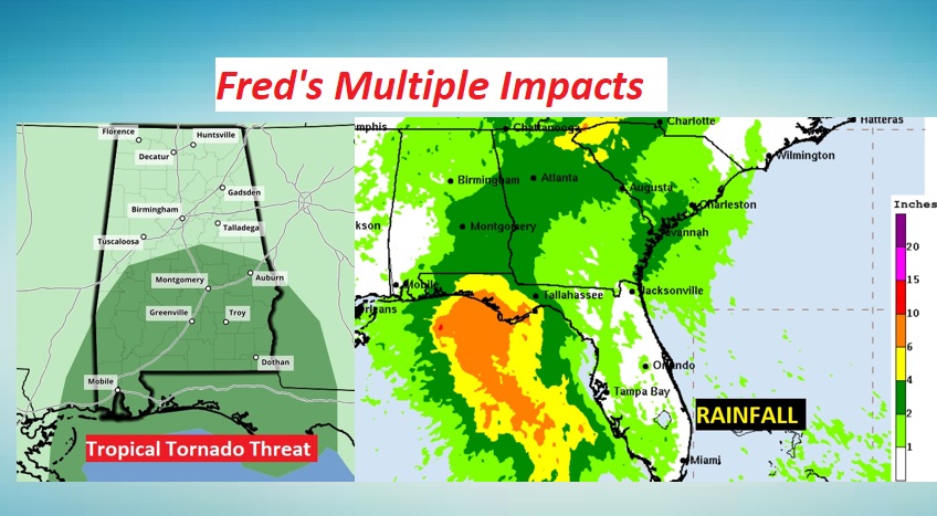
RAINFALL: 4-8” in the Panhandle isolated totals to 12”. Southeast Alabama 3 to 6”, locally 9” totals.
A couple of tropical tornadoes will be possible along and just east of Fred’s track.
4PM UPDATE ON GRACE:
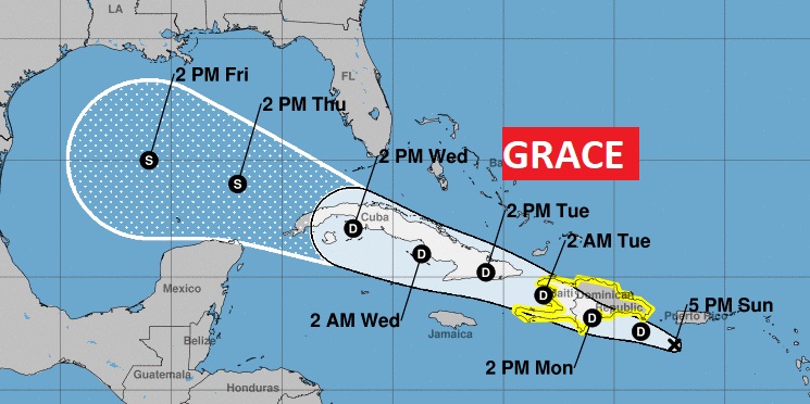
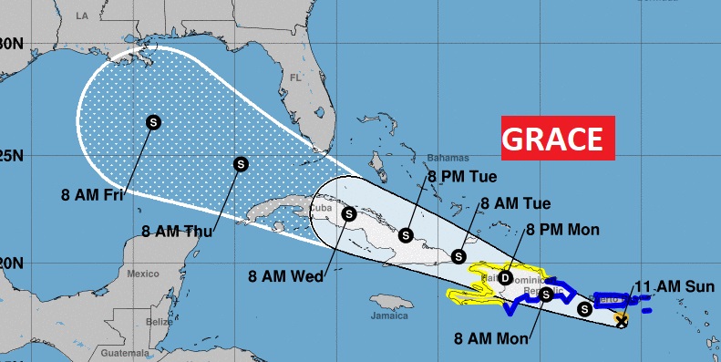
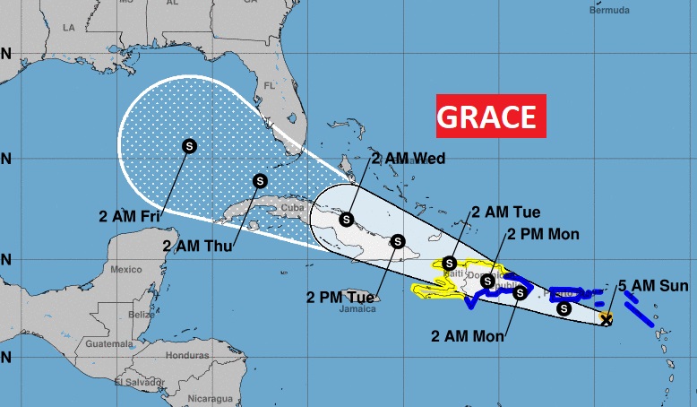
Grace is very disorganized and has been downgraded to a Tropical Depression. Now located near the the coast of Puerto Rico, it is morning West at 15 mph with winds of 35 MPH. Grace reach the mountainous island of Hispaniola Monday. Then, Grace will track to near or over eastern Cuba Tuesday, and west central Cuba Wednesday. Grace is destined to be another Gulf Tropical Storm. It’s ultimate destination next week is not known. The models do show it will intensify in the Gulf, but the models are not bullish of significant intensification at this point. Current forecast track has shifted south of the previous forecast.
10AM NHC UPDATE on the Remnants of FRED:
Fred is once again Tropical Storm Fred. Air Force Recon indicates it has a closed circulation. Winds are near 40 mph, moving NNW at 8 mph. Fred is forecast to be a 50 mph Tropical Storm when it arrives on the northern Gulf coast late Monday night. A Tropical Storm Warning has been issued from Navarre, FL. eastward through Panama City to the Florida Big Bend. Tropical Storm Watch from the Alabama/Florida border to Navarre.
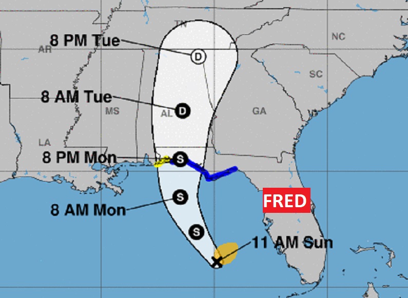
Fred will move northward through Alabama Monday night & Tuesday. The center line of the cone has shifted about 50 miles eastward. Main impacts: gusty winds to 25+ mph, tropical downpours and perhaps a couple of tropical sin-up tornadoes.
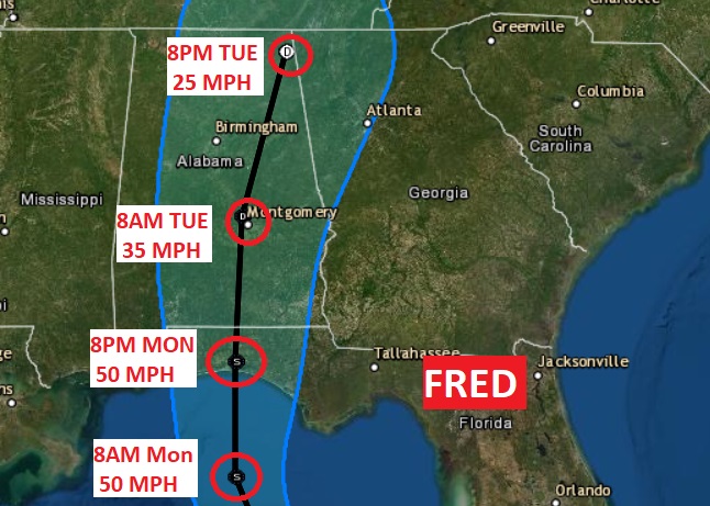
RAINFALL: 4-8” in the Panhandle isolated totals to 12”. South Central and Southeast Alabama 3 to 6”, locally 9” totals, as Fred interacts with a stalled front.
***10AM UPDATE ON TROPICAL STORM GRACE:
Grace is very disorganized this morning in the eastern Caribbean, 85 S of San Juan, PR. Grace is a minimal tropical storms with 40 mph winds, still moving WNW at 16 mph It will reach the mountainous Dominican Republic Monday. Like Fred, interaction with the mountains of Hispaniola will weaken Grace. Then, Grace will track to near or over eastern Cuba Tuesday, and west central Cuba Wednesday. Grace is destined to be another Gulf Tropical Storm. It’s ultimate destination next week is not known. Will it head for the northern Gulf coast? Or will it be a Texas, western Gulf problem? We simply do not know. Stay tuned.
8:30AM Bulletin:
BREAKING NEWS: Reports from an Air Force Reserve Hurricane Hunter aircraft indicate that Fred has regained tropical storm status over the southeastern Gulf of Mexico. Tropical Storm Warnings will be issued for portions of the northern Gulf coast on the 10AM Advisory.
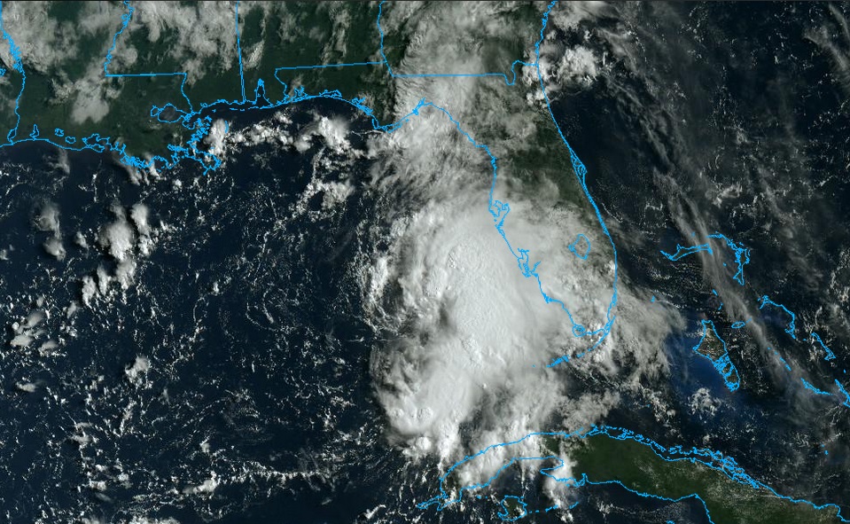
Good Morning! Once again today, the tropics will take center stage on this Blog update. Fred will have a big impact on our weather by Monday night and especially Tuesday. It’s trying to get it’s act together in the Gulf today, after it fell apart over Cuba. Tropical Storm Watch has been issued for the northern Gulf Coast.
Then, right behind Fred is Grace. It will eventually be yet another Gulf of Mexico problem next week. Where will Grace end up?
—
Meanwhile, Yesterday was the hottest day of August, with 97 in Montgomery and a heat index of 105. Big heat produces big storms. There were some BIG boomers yesterday evening! Some produced some very heavy rain. All of them had intense lightning. Today’s set up is similar to yesterday.
THE FUTURE OF FRED: The remnants of Fred are in the southeast Gulf this morning. Fred is trying to get it’s act together this morning. Winds are near 40 mph, moving NNW at 8 mph. As soon as a closed circulation is observed, Fred will once again be declared a Tropical Storm. Fred is forecast to be a 50 mph Tropical Storm when it arrives on the northern Gulf coast late Monday night or early Tuesday morning.
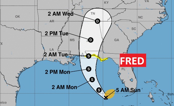
A Tropical Storm Watch has been issued from the Alabama/Florida border eastward through Panama City to about St. George Island, Florida. Fred will move northward through Alabama Tuesday with gusty winds, tropical downpours and perhaps a few tropical sin-up tornadoes.
RAINFALL: 4-8” in the Panhandle isolated totals to 12”. South Central and Southeast Alabama 3 to 6”, locally 9” totals, as Fred interacts with a stalled front.
TROPICAL STORM GRACE: Grace is very disorganized this morning in the eastern Caribbean, 150 SE of San Juan, PR. T is a minimal tropical storms with 40 mph winds, still moving rapidly WNW at 21 mph It will pass south of Puerto Rico today, and reach the mountainous Dominican Republic Monday. Like Fred, interaction with the mountains of Hispaniola will weaken Grace. Then, Grace will track into the southeast Bahamas, just north of Cuba…a very similar path to Fred. Grace is destined to be another Gulf Tropical Storm. It’s ultimate destination next week is not known. Will it head for the northern Gulf coast? Or will it be a Texas, western Gulf problem? We simply do not know. Stay tuned.
TODAY: High today 93. Heat index 100+. Partial sunshine again. There will be a generous supply of random showers & storms around, especially this afternoon & this evening. Some storms will be impressive, once again. Routine August day. Tonight’s low 73.
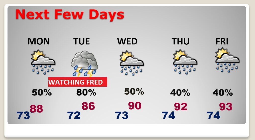
NEXT FEW DAYS: Monday won’t be quite as hot. High in the 80’s We await Fred. A little breezy, East winds 5 to 10 could gust to 20. Tuesday: Breezy. Tropical downpours, tropical tornado threat. A little more routine Wednesday through Friday. Scattered storms. Temperatures back to 90 or above.
.There will be more additions to this Blog update later in the day, as new information arrives on Fred and Grace. (Especially when we get the 10AM and 4PM Advisory) I’ll have a complete video update tomorrow morning. Have a great Sunday! Stay cool. Stay weather aware
–Rich
