
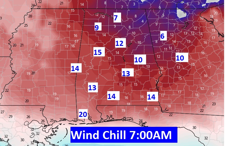
Good Morning! Old man winter has come to town. But, he won’t be here for long. A powerful “Bomb Cyclone” is producing a historic Blizzard in the Northeast states. That storm is the mechanism to funnel Cold Arctic Air deep into the Gulf South on gusty north and northwest wind. As I type this at 4AM, winds are gusting to 29 mph at Montgomery Regional (Dannely field). The Wind Chill is plummeting. Expect wind chill in the low to mid teens this morning. The wind will be a problem all day. Even later today wind chill will be in the 20’s and 30’s. Even a few snow flurries have been occurring over the northern 1/2 of Alabama from Auburn northward. Even with total sunshine today, we’ll struggle to reach the lower 40’s. We’re headed for the lower 20’s tonight.
BUT, we’ll see a remarkable temperature swing by Sunday afternoon. We’ll be back to around 60, and well into the 60’s next week.
On this blog update, I’ll fill you in on a two-part storm system next week.
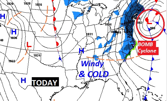
TODAY: Mostly sunny, windy and COLD. Morning temps in the 20’s. Afternoon high will struggle to reach the lower 40’s. Maybe. Northwest wind at 12 to 20 MPH gusting to 25 will be the main factor today. Morning wind chill low to mid teens. Even later today wind chill will be in the 20’s and 30’s. Winds die down a bit this evening and tonight. Clear and cold tonight. Low 24.
SUNDAY: Expect a very cold Sunday morning. Low 24. But, wind chill won’t be much of a factor. We’ll see a simply remarkable afternoon recovery. Sunshine. High 61!. Low Sunday night 35.
NEXT STORM SYSTEM: Looks like a two-part storm system by mid week. Part one Wednesday. Part 2 Thursday. Very mild. Highs in the 60’s. Showers and even a few thunderstorms. No severe weather is expected, as of now. Windy & colder behind the storm system on Friday.
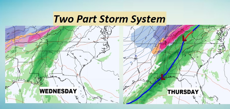
NEXT FEW DAYS: Remarkable after noon warm-up Sunday, after a cold start. Monday & Tuesday will be the best days of the week. Highs well into the 60’s. Two-part storm system Wednesday and Thursday. Windy & colder behind the storm system on Friday.
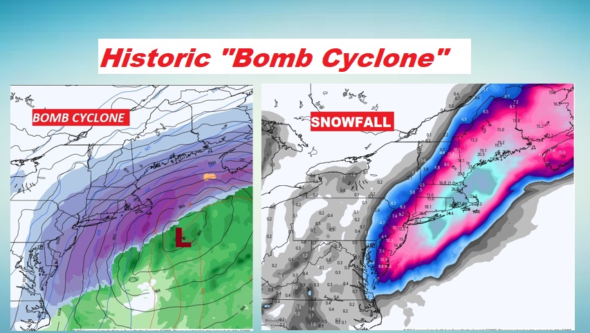
HISTORIC “Bomb Cyclone”: A bomb Cyclone is a meteorological term. It refers to storm that has intensified so quickly, the pressure drops 24 or more millibars in 24 hours. It’s the “perfect storm” in many ways. Everything is coming together at one time, to produce a Blizzard of historic proportion. Some spots could see 2-3 feet of snow. Wind gusts could reach hurricane force. Winds rushing around that storm is producing our gusty winds here in Alabama today.
I’ll have another Blog update in the morning. Stay warm! Have a nice weekend!
–Rich