
9:45 AM BULLETI N:
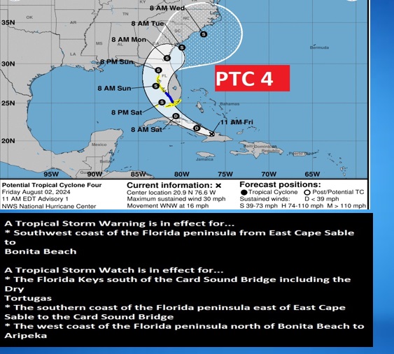
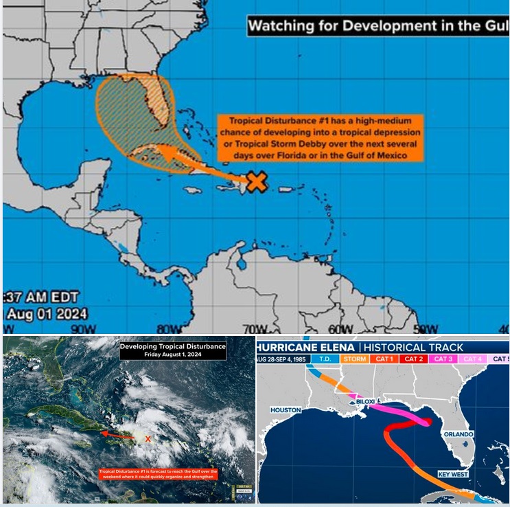
INVEST 97-L has been promoted to PTC 4. NHC does this for a system expected to develop but has not yet quite formed. This is done to enable the issuances of watches and warnings, which they have now done. PTC 4 is now over eastern Cuba. It is expected to make a long trek over Cuba and then curve into the Gulf, become a Depression and then Tropical Storm Debby. The NHC track curves Debby along the SE US Atlantic coast as a fairy minimum Tropical Storm with 45 mph winds. #alwx #FLWX
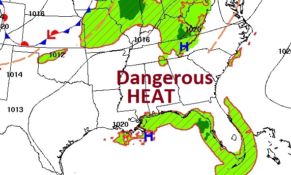
Good Morning! Welcome to August! HEAT ADVISORY continues again today. Dangerous Heat indices through least 105-110. Meanwhile, PM storms will be few and far between. Not much change in the extreme heat through Monday. Meanwhile, potential interesting future Trouble in the Tropics. The Gulf possibilities look interesting next week. Here’s my brief forecast discussion.
TODAY: HEAT ADVISORY, again. Mostly sunny. Random storms will be few and far between. High today 97. Heat index 105 to 110. Light win. Very muddy and warm tonight. Low 77
.
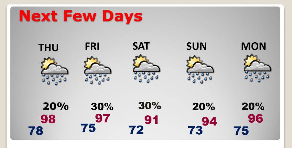
NEXT FEW DAYS: Extreme heat continues. Highs in the mid to upper 90’s will continue. Even lows at night will be in oppressive upper 70.s. Meanwhile, PM storms will be few and far between. Not much change in the extreme heat through Tuesday. PLUS, we’ll be watching the Gulf. More below on Tropical Development.
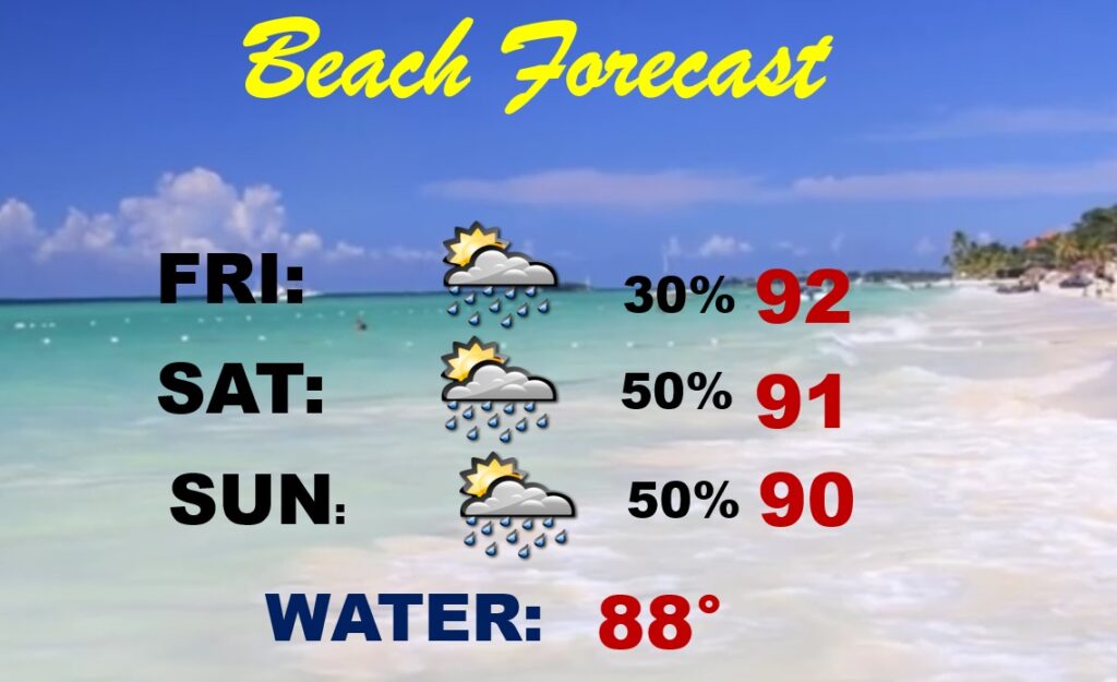
BEACH OUTLOOK: Looking fairly routine. Spotty random mainly PM storms. Highs 90-92. Lows at night near 80. However, watching the Gulf more closely starting Monday and through next week. Stay tuned.
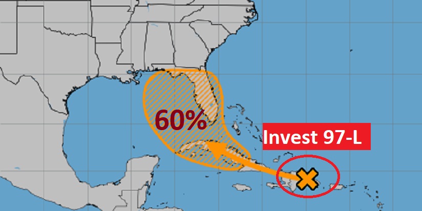
TROPICAL: 10am NHC update: It now has a number. INVEST 97-L could become a Depression in the E Gulf over the weekend. The system will stall and remain near the northern half of Florida or the nearby areas for a number of days. Areas from the northern Gulf coast to the Carolinas could be affected, and a looping track where the storm impacts the same areas multiple times is not out of the question. Stay tuned.
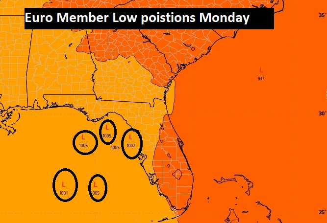
The EURO Ensembles “member LOWs” shows some members producing possible low pressure systems into the east Gulf by Monday. This has my attention.
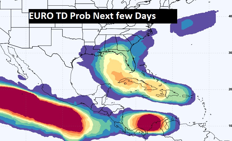
Here’s EURO potential Future Development region in the next few days.
FROM MY BUDDY BRYAN NORCROSS/FOX WEATHER:
TROPICS UPDATE: LATEST COMPUTER FORECASTS INDICATE THE TROPICAL SYSTEM COULD STALL AND IMPACT FLORIDA FOR DAYS
Welcome to August. The various computer forecast models have coalesced around the idea that the tropical disturbance (officially tagged Invest 97L) we’ve been following will track into the Gulf of Mexico. The National Hurricane Center still gives it a 60% chance of developing into a tropical depression or tropical storm over or near Florida. That would most likely happen over the weekend based on what we know now.
How strong the system gets and exactly when is an open question, but a couple of issues are consistent in the various predictions:
1. The system will drag a lot of moisture across the Florida peninsula and possibly surrounding states. Flooding rains are possible.
2. The system will stall and remain near the northern half of Florida or the nearby areas for a number of days. Areas from the northern Gulf coast to the Carolinas could be affected, and a looping track where the storm impacts the same areas multiple times is not out of the question.
On the current schedule, moisture will arrive in South Florida tomorrow and slowly spread up the state. Over the weekend and into next week, waves of gusty tropical downpours are possible. This is a large system, so bands of heavy rain may develop well away from the center, assuming one develops, which is more likely than not.
The best evidence we have at the current time is that the core of the disturbance (which we’ll watch to see if it becomes the center of circulation) will track over the mountains in the Dominican Republic and Cuba, keeping it disorganized until it moves away from the islands.
The trek over land will likely keep the system from coalescing into a depression at least until Saturday or Sunday. By the time the disturbance reaches the Gulf, where it has a chance to organize, the strong dip in the jet stream that was pulling it north is forecast to move on. High pressure from the heat dome over the middle of the US looks likely to block the system’s forward movement, leaving it to stall, loop, or otherwise be obnoxious.
When a tropical disturbance, depression, or storm moves north in the Gulf, the Florida peninsula is on the wet side of the system. Depending on how strong it gets and where it stalls or loops, some areas could get extreme amounts of rain with gusty winds, but it’s too early to know exactly where that might occur.
The obvious question is, could this become a hurricane in the Gulf? The answer is yes, but it could also remain as a large, weak, wet circulation as it tracks across North Florida, become a hurricane in the Atlantic, maybe impact the Georgia or Carolina coast, then loop back and impact some part of Florida again.
When a storm stalls because the steering currents collapse, even short-term forecasts can be drastically wrong because minor, hard-to-detect factors affect the system’s motion. Hurricane Elena was a nightmare storm in 1985 that drifted and looped over the Gulf. Evacuations were ordered on the northern Gulf coast, then in the Tampa Bay area, then eventually the storm hit Alabama and Mississippi. There was damage on the entire coastline.
I’m not saying that this will turn out exactly like Elena, but the forecast collapse of the steering pattern is reminiscent.
If and when the system develops a circulation with winds reaching 40 mph or higher, it will be named Tropical Storm Debby.
The current rough estimate is that the system will become a depression Saturday or early Sunday off the west coast of Florida, then slowly organize and intensify. The upper-air pattern is forecast to be conducive for strengthening, so we might have Tropical Storm Debby as soon as Sunday.
How the mountainous islands affect the disturbance will be a factor, but the system is so large it will likely not be terribly disrupted. The main point is, this COULD begin pretty quickly once the system reaches the Gulf. Notice my emphasis on could. It could also drag on for many days.
For now, we have to be ready for an extended period of rain over much of Florida, and everyone should check on their hurricane preparations just in case the system develops quickly over the warm waters of the Gulf.
Stay tuned.
Thanks for reading the blog. There will be another Blog update in the tomorrow morning. Due to health issues, I’m on the sidelines through the end of the week. COVID, \ and pneumonia,. Have a nice day!
–Rich