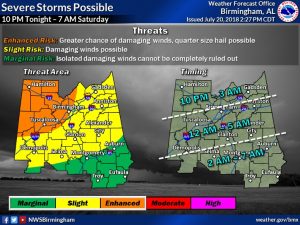
There’s no significant change in thinking on the overnight severe weather threat here in Alabama, except for a later time of arrival of the cluster of storms. The threat window extends from 10PM in the far NW counties to 7AM along and south of the I-85 corridor.
Damaging wind gusts of 60+ mph is still the main. Large hail is also possible. Any tornado threat would be extremely low in a situation like this. The greatest threat of widespread wind damage from this storm cluster would be along and north of the I-20 / I-59 Corridor. Farther south the risk diminishes quite a bit as you get along and south of I-85 /US 80.

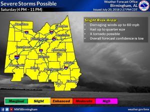
POSSIBLE ROUND TWO SATURDAY PM?: Another round of storms is possible Saturday afternoon and evening. Main threats continue to be damaging winds of up to 60 mph, with large hail and an isolated tornado possible, but the tornado threat is very low, torrential downpours and intense lightning. the main threat window would be from about 4PM to 11PM. That window could change.

—
Make sure you have our weather app on your phone and keep it handy during the night. It will instantly alert you to severe weather watches or warnings for your location. And, make sure your weather radio is also in the alert mode, so that you have more than one way to receive a warning. Stay weather aware. I’ll be watching radar and posting, too
-Rich
